 |
On-line Digital Images |
DP 105659 |
Records of the Royal Commission on the Ancient and Historical Monuments of Scotland (RCAHMS), Edinbu |
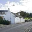
Street view showing 15, 17 and 19 Church Wynd, Bo'ness, taken from the North-West. The burial ground of Bo'ness Parish Church, dating from the 17th century, can also be seen in this image. This photograph was taken as part of the Bo'ness Urban Survey to illustrate the character of the Corbiehall and Snab Area of Townscape Character. |
20/9/2011 |
Item Level |
|
 |
On-line Digital Images |
DP 105661 |
Records of the Royal Commission on the Ancient and Historical Monuments of Scotland (RCAHMS), Edinbu |
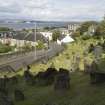
General street view showing Church Wynd, Bo'ness, taken from Bo'ness Parish Churchyard to the South-West. This photograph was taken as part of the Bo'ness Urban Survey to illustrate the character of the Corbiehall and Snab Area of Townscape Character. |
20/9/2011 |
Item Level |
|
 |
On-line Digital Images |
DP 105662 |
Records of the Royal Commission on the Ancient and Historical Monuments of Scotland (RCAHMS), Edinbu |
General street view showing Church Wynd, Bo'ness, taken from Bo'ness Parish Churchyard to the South-West. This photograph was taken as part of the Bo'ness Urban Survey to illustrate the character of the Corbiehall and Snab Area of Townscape Character. |
20/9/2011 |
Item Level |
|
|
Photographs and Off-line Digital Images |
DP 211788 |
Buildings at Risk Register |
Collapsed masonry |
27/1/2015 |
Item Level |
|
|
Photographs and Off-line Digital Images |
DP 211789 |
Buildings at Risk Register |
Ivy Growth to Boundary |
27/1/2015 |
Item Level |
|
|
Photographs and Off-line Digital Images |
DP 211790 |
Buildings at Risk Register |
Ivy Growth to Monuments |
27/1/2015 |
Item Level |
|
|
Photographs and Off-line Digital Images |
DP 211791 |
Buildings at Risk Register |
Collapsed masonry |
27/1/2015 |
Item Level |
|
|
Photographs and Off-line Digital Images |
DP 211792 |
Buildings at Risk Register |
Vegetation Growth to Boundary |
27/1/2015 |
Item Level |
|
|
Photographs and Off-line Digital Images |
DP 211793 |
Buildings at Risk Register |
Tree Collapse |
27/1/2015 |
Item Level |
|
|
Photographs and Off-line Digital Images |
DP 211794 |
Buildings at Risk Register |
Decayed Entrance Railing |
27/1/2015 |
Item Level |
|
|
Photographs and Off-line Digital Images |
DP 211795 |
Buildings at Risk Register |
Vegetation Growth to Boundary |
27/1/2015 |
Item Level |
|
 |
On-line Digital Images |
SC 1630670 |
List C Survey |
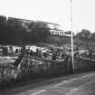
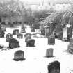
View of graveyard to E of Church Wynd. |
1975 |
Item Level |
|
 |
On-line Digital Images |
SC 1630671 |
List C Survey |
View of graveyard to W of Church Wynd. |
1975 |
Item Level |
|
 |
On-line Digital Images |
SC 1630672 |
List C Survey |
View of graveyard to W of Church Wynd. |
1975 |
Item Level |
|
|
Photographs and Off-line Digital Images |
DP 308977 |
Historic Environment Scotland |
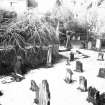
View of Churchyard |
|
Item Level |
|
|
Photographs and Off-line Digital Images |
DP 308978 |
Historic Environment Scotland |
View of Churchyard |
|
Item Level |
|
|
Photographs and Off-line Digital Images |
DP 308979 |
Historic Environment Scotland |
View of Churchyard |
|
Item Level |
|
|
Photographs and Off-line Digital Images |
DP 308980 |
Historic Environment Scotland |
View of encroaching vegetation so grave markers in boundary wall |
|
Item Level |
|
|
Photographs and Off-line Digital Images |
DP 308981 |
Historic Environment Scotland |
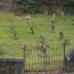
View of North Boundary Wall |
|
Item Level |
|
 |
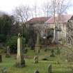
On-line Digital Images |
DP 322124 |
Records of the Royal Commission on the Ancient and Historical Monuments of Scotland (RCAHMS), Edinbu |
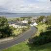
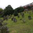
View from west showing Churchyard, Church Wynd, Bo'ness. |
24/1/2011 |
Item Level |
|
 |
On-line Digital Images |
DP 322125 |
Records of the Royal Commission on the Ancient and Historical Monuments of Scotland (RCAHMS), Edinbu |
View from south-west showing Churchyard, Church Wynd, Bo'ness. |
24/1/2011 |
Item Level |
|
 |
On-line Digital Images |
DP 322126 |
Records of the Royal Commission on the Ancient and Historical Monuments of Scotland (RCAHMS), Edinbu |
View from south-east showing Churchyard, Church Wynd, Bo'ness. |
24/1/2011 |
Item Level |
|
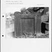 |
On-line Digital Images |
SC 2225125 |
Papers of Betty Willsher, historian, St Andrews, Scotland |
Photographs and research notes relating to graveyard monuments in Bo'ness Upper Churchyard, West Lothian.
|
|
Item Level |
|
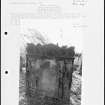 |
On-line Digital Images |
SC 2225127 |
Papers of Betty Willsher, historian, St Andrews, Scotland |
Photographs and research notes relating to graveyard monuments in Bo'ness Lower Churchyard, West Lothian.
|
|
Item Level |
|


