 |
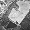
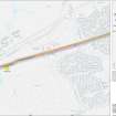
On-line Digital Images |
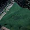
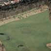
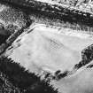
SC 337341 |
RCAHMS Aerial Photography |
Oblique aerial view of Kinneil fort and the Antonine Wall (c. 986 807), taken from the S. |
4/3/1997 |
Item Level |
|
 |
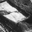
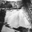
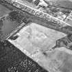
On-line Digital Images |
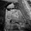
SC 349456 |
RCAHMS Aerial Photography |
Oblique aerial view |
1982 |
Item Level |
|
 |
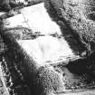
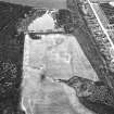
On-line Digital Images |
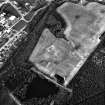
SC 353625 |
RCAHMS Aerial Photography |
Oblique aerial view |
1982 |
Item Level |
|
 |
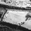
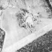
On-line Digital Images |
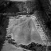
SC 624027 |
RCAHMS Aerial Photography |
Kinneil Roman Fortlet, oblique aerial view, taken from the ENE. |
20/2/1996 |
Item Level |
|
 |
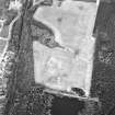
On-line Digital Images |
SC 902614 |
RCAHMS Aerial Photography |
Oblique aerial view of Kinneil fortlet and the Antonine Wall (c. 9800 8052), taken from the SSE. |
4/3/1997 |
Item Level |
|
 |
On-line Digital Images |
SC 1729310 |
|
Kinneil Roman Fortlet, oblique aerial view, taken from the WNW. |
20/2/1996 |
Item Level |
|
 |
On-line Digital Images |
SC 1729311 |
|
Kinneil Roman Fortlet, oblique aerial view, taken from the W. |
20/2/1996 |
Item Level |
|
 |
On-line Digital Images |
SC 1729312 |
RCAHMS Aerial Photography |
Kinneil Roman Fortlet, oblique aerial view, taken from the SSE. |
20/2/1996 |
Item Level |
|
 |
On-line Digital Images |
SC 1729313 |
RCAHMS Aerial Photography |
Kinneil Roman Fortlet, oblique aerial view, taken from the ESE. |
20/2/1996 |
Item Level |
|
 |
On-line Digital Images |
SC 1729314 |
RCAHMS Aerial Photography |
Kinneil Roman Fortlet, oblique aerial view, taken from the ENE. |
20/2/1996 |
Item Level |
|
 |
On-line Digital Images |
SC 1729370 |
RCAHMS Aerial Photography |
Oblique aerial view. |
1981 |
Item Level |
|
 |
On-line Digital Images |
SC 1729371 |
RCAHMS Aerial Photography |
Oblique aerial view. |
1982 |
Item Level |
|
 |
On-line Digital Images |
SC 1729372 |
RCAHMS Aerial Photography |
Oblique aerial view |
1982 |
Item Level |
|
 |
On-line Digital Images |
SC 1729373 |
RCAHMS Aerial Photography |
Oblique aerial view. |
1982 |
Item Level |
|
 |
On-line Digital Images |
SC 1729374 |
RCAHMS Aerial Photography |
Oblique aerial view |
1982 |
Item Level |
|
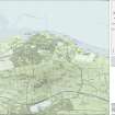 |
On-line Digital Images |
SC 1919937 |
Records of Historic Scotland, Edinburgh, Scotland |
Map 1 of 8 from IV.I 1-8 - Series 1: Maps of the Antonine Wall at a scale of 1:25000 showing the proposed World Heritage Site, known forts and fortlets, camps, other features and the buffer zones. Maps were prepared for the nomination document to propose the extension of the Frontiers of the Roman Empire World Heritage Site through the addition of the Antonine Wall. |
2006 |
Item Level |
|
 |
On-line Digital Images |
SC 1926676 |
Records of Historic Scotland, Edinburgh, Scotland |
Map 1 of 8 from IV.2 1-8 - Series 2: Maps of the Antonine Wall at a scale of 1:25000 showing the proposed World Heritage Site, known forts and fortlets, camps, other features and the buffer zones. Maps were prepared for the nomination document to propose the extension of the Frontiers of the Roman Empire World Heritage Site through the addition of the Antonine Wall. |
2006 |
Item Level |
|
 |
On-line Digital Images |
SC 1928156 |
Records of Historic Scotland, Edinburgh, Scotland |
Map 4 of 39 from Series V. Maps of the Antonine Wall and its known features at a scale of 1:5000 showing the scheduled areas and the proposed World Heritage Site. Maps were prepared for the nomination document to propose the extension of the Frontiers of the Roman Empire World Heritage Site through the addition of the Antonine Wall. |
2006 |
Item Level |
|
 |
On-line Digital Images |
SC 1970706 |
Records of Historic Scotland, Edinburgh, Scotland |
Antonine Wall 1:25000 broadsheet map |
2008 |
Item Level |
|
 |
On-line Digital Images |
SC 2170806 |
Records of Historic Scotland, Edinburgh, Scotland |
Map showing the Antonine Wall, the World Heritage Site area, the areas of the World Heritage Site in public ownership or care, the Buffer Zone and the Council boundaries. Created for the World Heritage Site nomination - Management plan. |
2006 |
Item Level |
|
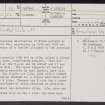 |
On-line Digital Images |
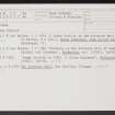
SC 2434981 |
Records of the Ordnance Survey, Southampton, Hampshire, England |
Kinneil, NS98SE 15, Ordnance Survey index card, page number 1, Recto |
1958 |
Item Level |
|
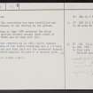 |
On-line Digital Images |
SC 2434982 |
Records of the Ordnance Survey, Southampton, Hampshire, England |
Kinneil, NS98SE 15, Ordnance Survey index card, page number 2, Verso |
1958 |
Item Level |
|
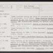 |
On-line Digital Images |
SC 2434983 |
Records of the Ordnance Survey, Southampton, Hampshire, England |
Kinneil, NS98SE 15, Ordnance Survey index card, page number 1, Recto |
1958 |
Item Level |
|
 |
On-line Digital Images |
SC 2434984 |
Records of the Ordnance Survey, Southampton, Hampshire, England |
Kinneil, NS98SE 15, Ordnance Survey index card, page number 2, Recto |
1958 |
Item Level |
|


