
Gormyre, Refuge Stone


Sanctuary Marker (Medieval)
Site Name Gormyre, Refuge Stone
Classification Sanctuary Marker (Medieval)
Alternative Name(s) Torphichen Preceptory, Refuge Stone At Easter Gormyre Farm; Easter Gormyre, Sanctuary Stone
Canmore ID 47915
Site Number NS97SE 12
NGR NS 98063 73112
Datum OSGB36 - NGR
Permalink http://canmore.org.uk/site/47915


- Council West Lothian
- Parish Torphichen
- Former Region Lothian
- Former District West Lothian
- Former County West Lothian
NS97SE 12 9806 7311
See also NS97SW 2, and NS97SE 22, NS97SE 25, NS97SE 30.
For Torphichen Preceptory (NS 96893 72516) and associated monuments, see NS97SE 7.
(NS 9806 7311) Refuge Stone (NR)
OS 6" map (1968)
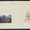
This quadrilateral upright boulder stands on the summit of a low flat-topped ridge. Of hard red grit, it is c. 4' high, 2' 8" x 2' wide at bottom, and 3' 5" wide at top. The ONB notes that the outline of a Maltese cross, almost obliterated, may be seen on the N face of the stone, when viewed from a few yards away. This is one of the stones marking the area of the sanctuary associated with Torphichen Preceptory
Name Book 1856; Prof Duns 1878; RCAHMS 1929, visited 1923.
As described above, though there is now no trace of the cross mentioned.
Visited by OS (JLD) 5 December 1952 and (JP) 14 August 1974.
Field Visit (8 May 1923)
Refuge Stone.
In the second field north-east of Gormyre Farm, about 19 yards west of the stone dyke, is a quadrilateral upright boulder of hard red grit, 2 feet 8 inches wide by 2 feet thick at bottom and 3 feet 5 inches high by 21 inches wide at top. Its base is wedged in with smaller stones, and it stands on the summit of a low fiat-topped ridge rising above the marshy pasture.
RCAHMS 1929, visited 8 May 1923
OS 6-inch map: v S.W.

