
Arbory Hill


Building (Post Medieval), Cord Rig (Prehistoric), Fort(S) (Prehistoric), Linear Earthwork (Prehistoric), Palisaded Enclosure (Prehistoric), Ring Ditch House(S) (Prehistoric), Roundhouse(S) (Prehistoric), Scraper (Tool) (Chert)(Period Unknown)
Site Name Arbory Hill
Classification Building (Post Medieval), Cord Rig (Prehistoric), Fort(S) (Prehistoric), Linear Earthwork (Prehistoric), Palisaded Enclosure (Prehistoric), Ring Ditch House(S) (Prehistoric), Roundhouse(S) (Prehistoric), Scraper (Tool) (Chert)(Period Unknown)
Canmore ID 47427
Site Number NS92SW 2
NGR NS 9445 2379
Datum OSGB36 - NGR
Permalink http://canmore.org.uk/site/47427


- Council South Lanarkshire
- Parish Lamington And Wandel
- Former Region Strathclyde
- Former District Clydesdale
- Former County Lanarkshire
NS92SW 2 9445 2379.
(NS 9445 2379) Cairn (NR).
OS 6" map (1957)
(RCAHMS 1978, visited 1975; D Christison 1890; Proc Soc Antiq Scot 1932)
This fort is as described and planned by the RCAHMS.
Surveyed at 1:10 000.
Visited by OS (NKB) 26 March 1978
NS 944 238. Fort, Linear Earthwork and Cultivation Remains, Arbory Hill: visible on aerial photographs.
Cord rig noted at NS 944 238.
P Topping 1989.
Measured Survey (27 August 1959)
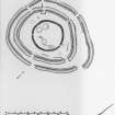
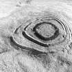
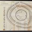
The fort at Arbory Hill was planned by RCAHMS as part of the Marginal Land Survey on 27 August 1959 at a scale of 1mm : 1ft (c. 1:300). The survey drawing (LAD 126/1) was redrawn in ink in 1974 (LAD 126/2) and reproduced at a much reduced scale in 1978 as Fig. 45.
Field Visit (February 1975)
Fort, Arbory Hill.
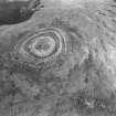
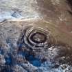
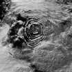
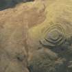
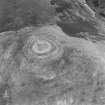
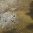
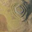
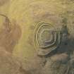
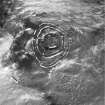
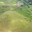
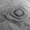
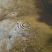
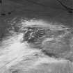
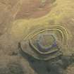
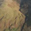
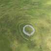
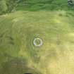
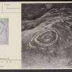
The summit of Arbory Hill (429m OD), which overlooks the right bank of the River Clyde about 1.2km ENE of Abington, is occupied by the conspicuous remains of a fort exhibiting two distinct structural phases. On three sides the steep fall of the ground affords exceptionally strong natural protection, and the only easy approach to the site is across a comparatively narrow saddle from the E.
In its first phase the fort measured 82m by 69m internally and was defended by two walls (IA, IB), the core material for which was largely obtained from external quarry-ditches; in addition, a low counterscarp bank was constructed in places on the outer lip of both the inner and outer ditch, as shown on the plan. Wall IA appears as a grass-covered stony bank measuring 5.2m in average thickness and standing to a height of as much as 3.0m above the bottom of the ditch, but only 0.6m above the level of the interior; a short stretch and two isolated stones of the outer wall-face have survived in situ on the E and SW respectively. The outer wall (IB) is of the same appearance generally, but of marginally slighter proportions; stones belonging to the outer face can be seen projecting through the turf at various points on the E half of the perimeter. There are five entrances, of which two, situated on the S and E, lead obliquely through the inner and outer walls. The NW entrance, which is flanked for a short distance by a low scarp, issues, at its inner end, into a hollow measuring 7.6m by 3.7m; the purpose of this feature is unknown.
Within the interior of the fort the sites of four contemporary timber houses adjacent to wall IA are indicated by two shallow depressions (1, 2), measuring respectively 6.0m by 4.6m and 3.7m in diameter, and by two crescentic scarps (3, 4), each measuring about 3.4m across. Several small contiguous scarps situated just inside wall IA on the E quadrant presumably represent quarries from which core material for that wall was obtained.
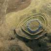
At some later date a single stone wall (II), enclosing a roughly circular area 43m in diameter, was built inside the earlier circuit. Although the wall now appears as a mass of tumbled debris up to 9.8m in width, its original thickness, judging by the few facing-stones that are still visible, does not seem to have exceeded 3.0m. Of the two entrances, that on the E measures 2.1m in width, and that on the SW only 1.2m; in neither case is the entrance approached directly through a gap in the earlier defences.
Within the area enclosed by wall II, and probably contemporary with it, there are fragmentary traces of three ring-ditch houses (5, 6, 7), which appear to have measured respectively 9.1m, 8.5m and 7.9m overall. A crescentic scarp (8) measuring 5.8m across, which lies immediately to the W of 5, may mark the site of a timber house belonging to the earlier phase. The only other internal features are a roughly circular pile of stones on the N, and the ruins of a stone building, rounded at one end, to which is attached a short length of walling; all of these appear to be of comparatively recent date.
About 75m to the ESE of the fort there are the slight remains of a linear earthwork, drawn across the saddle from the brink of the steep descent on the SSW to the edge of a broad natural hollow on the NNE. About 52m in length, it now appears at best as a low grassy bank some 3.7m in thickness, with a quarry ditch on the E side. Two boulders embedded in the scarp of the bank, as shown on the plan, may be the remains of an external stone revetment. Evidence from comparable sites in the adjacent county of Peeblesshire (RCAHMS 1967, i, 27) suggests that the earthwork was constructed in the earlier phase of the fort, its purpose being to impede access along a natural line of approach.
RCAHMS 1978, visited February 1975
NS 944 238
Publication Account (1985)
The elevated (429m OD) and isolated position of this fort has led not only to the excellent preservation of its two-period defences but also to the rare survival (for Lanarkshire) of parts of its contemporary field-system. These features, combined with the magnificent view of the Clydesdale gained from the summit, more than compensate for the arduous climb up from the road.
The earlier defences consist of two sets of ramparts with outer ditches and counterscarp banks. For the greater part of their circuit the ramparts are concentric and closely spaced but, on the east, their lines diverge creating a space that could have been used as a corral for cattle (such an interpretation is reinforced by the appearance of a staggered entrance at the mouth of the corral which would have aided the passage of stock). An unusual feature of this phase of the fort is the provision of five entrances; this seems excessive and would have weakened the defensive capacity of the fort.
In the second period, and in keeping with many other forts in Lanarkshire, the area to be defended, or at least enclosed, was reduced by about 50%. This time, instead of constructing ramparts and ditches, a stone walled enclosure was built and the number of entrances was reduced to two. Within the enclosure these are traces of three ring-ditch houses as well as a single house-platform, and between the wall and the Period 1 inner rampart there are several other vague platforms that may be the sites of timber houses.
About 75m east of the fort, there is a linear earthwork drawn across the neck of the saddle which leads to the higher ground beyond. Such earthworks are frequently found associated with forts in the Borders and were once thought to form some sort of outer defence line. Recent work, however, suggests that they are part of contemporary field-systems and acted as stock barriers, keeping cattle away from the vicinity of the fort. This was necessary, as the area immediately around the fort appears to have been cultivated, and air photographs taken when there was a light dusting of snow have revealed traces of narrow (c 1.2m) cultivation ridges which radiate down the hill away from the outer rampart. Because these remains are so slight they can barely be seen from the ground; their discovery, however, has been one of the most significant recent developments in iron-age settlement studies, and examples of this cord rig have been found widely in the Border counties but, so far Arbory is the only known example in Lanarkshire.
Information from ‘Exploring Scotland’s Heritage: The Clyde Estuary and Central Region’, (1985).
Geophysical Survey (February 1990)
Detailed survey of several sites in the area prior to the M74 motorway.
Note (21 August 2014 - 31 August 2016)
Situated on the summit of Arbory Hill, which is itself the W spur of the ridge of higher hills to the E, this is one of the higher forts in Scotland. Its defences reveal at least three phases of construction, in which an inner stone-walled enclosure has been inserted into the interior of a larger bi-vallate fort, which has itself replaced an earlier palisaded enclosure. The inner enclosure, which is roughly circular and measures 43m in internal diameter (0.14ha), was defended by a substantial wall, now spread up to 9.8m but probably originally in the order of 3m in thickness, and has entrances on the E and SW. This occupies the centre of the earlier fort, the interior of which measures 82m from E to W by 69m transversely (0.42ha). The earlier defences comprise two stone ramparts, each with an external ditch accompanied in places by a counterscarp bank; the inner of these ramparts forms a bank about 5.2m in thickness, standing no more than 0.8m in height internally, but up to 3m above the bottom of the ditch. The two lines are roughly concentric about 5m apart around the southern half of the circuit, but diverge to 8m on the NW, and as much as 20m on the ENE, to form the outer terminal of the staggered entrance in the outer rampart on the E. This is one of five entrances that penetrate both ramparts, the others being on the S, W, WNW and N respectively, but whereas the inner and outer gaps of those in the NW quadrant are roughly opposed, on the E and S the gaps are offset to expose the righthand side of approaching traffic; while these latter may be an expression of defensive architecture, they may also hint that the inner and outer ramparts of the outer circuits are not contemporary, the outer enclosing an overall area of 0.88ha. The evidence of the earlier timber perimeter is most clearly seen at the E entrance, where a minor outward deviation in the line of the inner rampart to create a slight stagger at the gap has revealed the line of the earlier palisade trench, which is otherwise mainly buried beneath the rampart round the rest of the circuit. Within the outer ramparts there are traces of the stances of at least seven timber round-houses, three of which had internal ring-ditches and lie within the inner enclosure.
Information from An Atlas of Hillforts of Great Britain and Ireland – 31 August 2016. Atlas of Hillforts SC1627

