
Low Gilkerscleuch


Country House (17th Century)
Site Name Low Gilkerscleuch
Classification Country House (17th Century)
Alternative Name(s) Gilkerscleuch House
Canmore ID 47419
Site Number NS92SW 12
NGR NS 9032 2301
Datum OSGB36 - NGR
Permalink http://canmore.org.uk/site/47419


- Council South Lanarkshire
- Parish Crawfordjohn
- Former Region Strathclyde
- Former District Clydesdale
- Former County Lanarkshire
NS92SW 12 9032 2301.
(NS 90322301) Gilkerscleuch House (NR).
OS 6" map (1957)
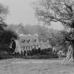
The small mansion of Gilkerscleuch probably dates from the early 17th century, with modern additions to W and N which are an exceptionally good copy of the original work, so that the mansion appears homogeneous. The original house is represented by a small oblong block, running N-S, with a circular stair-tower projecting NW. It is probable that the original plan was L-shaped. The walls are rubble-built, with freestone dressings. A doorway near the centre of the E wall is surmounted by a panel dated 1696.
N Tranter 1935
Gilkerscleugh House (Mrs J Brzygrodzki, owner) was generally as described by Tranter when visited in 1955; a second stone, dated 1668 was also noted in the E wall. However, it was demolished by 1965 (N Tranter 1965)
Visited by OS (JD) 13 July 1955
All that remains of Gilkerscleuch House are the foundations overgrown with turf.
Visited by OS (NKB) 28 April 1978
NMRS REFERENCE
Demolished 1958.
Geophysical Survey (February 1990)
Detailed survey of several sites in the area prior to the M74 motorway.

