
Castle Dykes


Fort (Period Unassigned)(Possible)
Site Name Castle Dykes
Classification Fort (Period Unassigned)(Possible)
Canmore ID 47364
Site Number NS92NW 1
NGR NS 9425 2871
Datum OSGB36 - NGR
Permalink http://canmore.org.uk/site/47364


- Council South Lanarkshire
- Parish Wiston And Roberton
- Former Region Strathclyde
- Former District Clydesdale
- Former County Lanarkshire
NS92NW 1 9425 2871.
(NS 94252871) Castle Dykes (NR)
OS 6" map (1959)
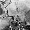
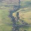
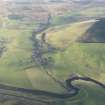
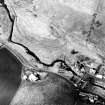
Castle Dykes lies W of Roberton, on a small, steep-sided knoll. The main western part of the knoll has a flat top surrounded by slight ramparts which appear to represent a small fort of the sub-Roman or early medieval period. The interior is irregular with slight mounds and hollows.
C A R Radford 1954
Reid suggests that when the motte (NS92NW 2) was abandoned, it was replaced by a stockaded manor house at Castle Dykes.
R C Reid 1958
A much mutilated bank follows the edge contour of this steeply sloped natural hill, forming a defensive enclosure. At the W end the bank is destroyed or overlaid by the field banks and croft enclosures of a small building, the foundations of which can be traced, by the stream. They do not appear to be of any antiquity. Nothing of significance was noted in the interior, again much mutilated.
Visited by OS (WW) 21 June 1955
As these earthworks are thought to be almost certainly medieval, they have been omitted from the Inventory.
RCAHMS 1978
A defended earthwork generally as described above. Although its period cannot be determined with certainty it does seem likely to be of a medieval origin.
Surveyed at 1:2500.
Visited by OS (BS) 1 August ?1978
Field Visit (2 September 1942)
This site was included within the RCAHMS Emergency Survey (1942-3), an unpublished rescue project. Site descriptions, organised by county, vary from short notes to lengthy and full descriptions and are available to view online with contemporary sketches and photographs. The original typescripts, manuscripts, notebooks and photographs can also be consulted in the RCAHMS Search Room.
Information from RCAHMS (GFG) 10 December 2014.
Geophysical Survey (February 1990)
Detailed survey of several sites in the area prior to the M74 motorway.
Note (25 August 2014 - 23 May 2016)
What may be the remains of a fort is situated in Roberton village on a steep-sided hillock that is formed between the N bank of the Roberton Burn and a glacial outwash channel. Roughly D-shaped on plan, it measures about 110m from ESE to WNW along the chord by a maximum of 37m transversely (0.3ha) within a heavily degraded rampart, which at the WNW end is apparently accompanied by two rock-cut ditches cutting across the spine of the hillock. There are entrances at both ends, that on the WNW now blocked by the bank of a rectilinear enclosure that is probably associated with a rectangular building at the foot of the slope. Another old field-bank can be seen traversing the WNW end of the interior, which has probably been cultivated.
Information from An Atlas of Hillforts of Great Britain and Ireland – 23 May 2016. Atlas of Hillforts SC1666

