
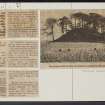
Hills Of Dunipace


Natural Feature(S) (Period Unknown)
Site Name Hills Of Dunipace
Classification Natural Feature(S) (Period Unknown)
Canmore ID 47049
Site Number NS88SW 6
NGR NS 837 817
Datum OSGB36 - NGR
Permalink http://canmore.org.uk/site/47049


- Council Falkirk
- Parish Dunipace
- Former Region Central
- Former District Falkirk
- Former County Stirlingshire
NS88SW 6 837 817.
(NS 837 817) Hills of Dunipace (NR)
OS 6" map (1913)
Hills of Dunipace (NAT)
OS 1:10000 map (1974)
The numerous natural mounds in the valley of the River Carron have been identified by geologists as the remains of the 100' raised beach. The "Hills of Dunipace" are examples of this class of mound and are not artificial. They have, however, long been associated with tradition and legend. There are no signs of any defensive or other works on them. RCAHMS 1963, visited 1954; NSA 1845; W Macfarlane 1906; O G S Crawford 1949; Falkirk Herald, 11 February 1983
The SE mound is about 60.0m in diameter and 20.0m high; its top is flat. The NW mound is of irregular shape; its top is broken and tree-covered. No remains of buildings, ditch or bailey was seen, associated with either mound.
Visited by OS (FDC) 19 July 1950 .

