
Falkirk, Camelon


Fort (Iron Age), Palisaded Enclosure (Iron Age), Roundhouse(S) (Iron Age)
Site Name Falkirk, Camelon
Classification Fort (Iron Age), Palisaded Enclosure (Iron Age), Roundhouse(S) (Iron Age)
Canmore ID 46922
Site Number NS88SE 24
NGR NS 8632 8115
Datum OSGB36 - NGR
Permalink http://canmore.org.uk/site/46922


- Council Falkirk
- Parish Falkirk
- Former Region Central
- Former District Falkirk
- Former County Stirlingshire
NS88SE 24 8632 8115
(NS 8632 8115) Fort (NR) (site of)
OS 6" map (1967)
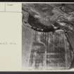
Air photographs reveal the crop marks of a native fort in the N corner of the plateau on which stand the Roman forts of Camelon (NS88SE 23).
It was excavated in 1961 by an extra-mural class of Edinburgh University under Miss E Field, who confirmed that it was bounded by four concentric ditches, visible on A Ps as running in a curve from the NW edge of the plateau to within 50' of the NE edge, where there may have been an entrance. Within the interior, which measures about 150' N-S by 200' E-W, were found the foundation trenches of an oval house, greatest diameter 40', a rectangular structure, possibly an open enclosure, and a round house cut through the foundation trenches of the above. All the pottery discovered, without stratigraphic relations to the structure, was Roman, from the adjacent fort.
S Cruden 1961; RCAHMS 1963, visited 1953.
There is no trace of this promontory fort. Recent quarrying on the NW side has exposed sections of two ditches.
Site surveyed at 1:1250.
Visited by OS (DWR) 8 February 1974
The site has been entirely destroyed by old quarrying. The overall size, the internal round houses and the possible palisade nature of the concentric ditches, suggest this was a homestead rather than a fort.
Visited by OS (JRL) 15 April 1980
Full excavation report of this native site illustrates that there were three phases of occupation, represented by two circular timber houses, with part of a rectilinear structure, possibly of Roman origin, between. A complex defence system was revealed, but could not be related to the sequence of occupation of the site which was apparently in use during the 1st and 2nd centuries AD. The three substantial ditches suggest a fortification rather than a homestead, although by analogy it is probably an earlier homestead with palisade ditches, later fortified more strongly.
E V W Proudfoot 1980.
Aerial Photographic Interpretation (6 December 1953)
NS88SE 863 811 (unnoted)
Fort, Camelon (Site).
Air-photographs taken by Dr. St. Joseph (1) reveal the crop-markings of a native fort (Fig. 46, K) in the N. corner of the plateau on which stand the Roman forts of Camelon (No. 122). The markings comprise four dark, narrow, parallel lines, presumably representing ploughed-down ditches or palisade-trenches, which run in a curve from the NW. edge of the plateau to within about 50 ft. of the NE. edge, where there may have been an entrance. The innermost and third lines appear to be somewhat broader than the other two. Within the interior, which measures about 150 ft. from N. to S. by about 200 ft. from E. to W., the same photographs distinctly show the crop-mark of an enclosure, probably a hut, bounded by a single ditch or palisade-trench. Oval on plan, the enclosure measures about 50 ft. by 40 ft. and appears to have an entrance facing towards the S.
RCAHMS 1963, visited 6 December 1953
(1) Nos. DH 022-4 in the CUCAP
Reference (1957)
This site is noted in the ‘List of monuments discovered during the survey of marginal land (1951-5)’ (RCAHMS 1957, xiv-xviii).
Information from RCAHMS (GFG), 24 October 2012.
Excavation (April 1961 - July 1961)
Iron Age Promontory Fort, Camelon.
Excavation was carried out by an Extra-Mural class of Edinburgh University under the supervision of Miss E V W Field [Proudfoot]. The fort is bounded by four concentric ditches: within it were found the foundation trenches of an oval home of greatest diameter 40 ft., a rectangular structure, possibly an open enclosure, and a round house cut through the foundation trenches of the above. All the pottery discovered, without stratigraphic relations to the structure, was Roman from the adjacent fort and annexe.
Information from S H Cruden, Inspectorate of Ancient Monuments
(DES 1961, 54-5)
Note (1978)
Camelon NS 863 811 NS88SE 24
This fort, or heavily defended homestead, has been destroyed by gravel digging; the surviving portion measured 60m W to E by 45m transversely across the interior; situated on a promontory and defended by four concentric ditches and two lines of palisade on the S side. Excavation revealed three successive phases of timber buildings with no associated dating material.
RCAHMS 1978
(DES, 1961, 54-5; RCAHMS 1963, p.80, No.82; Breeze, Close-Brooks and Ritchie 1976, 73-4)
Note (17 August 2014 - 23 May 2016)
The remains of a fort revealed by cropmarks on a promontory along the escarpment of an ancient shoreline, was destroyed by gravel extraction in 1961. Excavations immediately prior to its destruction uncovered at least three concentric ditches and the lines up to five palisade trenches, probably representing a series of successive enclosures cutting off the relatively easy southern approaches to the promontory. Estimates of the original size of the interior range widely, from 60m from E to W by 45m transversely by RCAHMS investigators (RCAHMS 1963, 80, no.82) to 82m by 73m respectively by the excavator (Proudfoot 1978, 115), and 75m by 65m scaled from the plan (Proudfoot 1978, 114, fig 2), though the latter shows the internal houses slightly large than the measurements given in the text; nevertheless, the area enclosed behind the inner ditch, which was over 6m in breadth and 4m in depth, was at least 0.3ha in extent, and in at least one phase there was probably an entrance on the SSE. The stratigraphic relationships between the three ditches are unknown, nor indeed with the palisade trench that lay between the inner and middle ditches, and it is possible that any one of these lines may represent the remains of an independent defence enclosing a larger area. At least three other palisade trenches enclosing smaller areas were also located within the interior, and within the inner of these was a large timber round-house 14.6m in diameter, which had been erected on the site of an earlier oval structure measuring about 14m by 11m. While the finds from the floor of the later round-house and two adjacent pits broadly fall in the 1st-2nd centuries AD, it is likely that the multiple lines of ditches and palisades found here represent a much longer chronology of occupation and fortification.
Information from An Atlas of Hillforts of Great Britain and Ireland – 23 May 2016. Atlas of Hillforts SC1544

