|
Photographs and Off-line Digital Images |
ST 2659 PO |
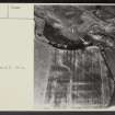
Cambridge University Collection for Aerial Photography |
Aerial photograph, 6 July 1949 |
6/7/1949 |
Item Level |
|
|
Photographs and Off-line Digital Images |
ST 2660 PO |
Cambridge University Collection for Aerial Photography |
Aerial photograph, 6 July 1949 |
6/7/1949 |
Item Level |
|
|
Photographs and Off-line Digital Images |
ST 2661 PO |
Cambridge University Collection for Aerial Photography |
Aerial photograph, 6 July 1949 |
6/7/1949 |
Item Level |
|
|
Photographs and Off-line Digital Images |
A 83671 PO |
|
General view of houses, E V W Proudfoot |
1961 |
Item Level |
|
|
Photographs and Off-line Digital Images |
A 83672 PO |
|
House 2 and House 1 with F3, E V W Proudfoot |
1961 |
Item Level |
|
|
Photographs and Off-line Digital Images |
A 83673 PO |
|
Foundation trench house 2, E V W Proudfoot |
1961 |
Item Level |
|
|
Photographs and Off-line Digital Images |
A 83674 PO |
|
Feature 1 before excavation, E V W Proudfoot |
1961 |
Item Level |
|
|
Photographs and Off-line Digital Images |
A 83675 PO |
|
Ditch C, E V W Proudfoot |
1961 |
Item Level |
|
|
Photographs and Off-line Digital Images |
A 83676 PO |
|
Ditch C, E V W Proudfoot |
1961 |
Item Level |
|
|
Photographs and Off-line Digital Images |
A 83677 PO |
|
Ditch A, Ditch B - palisade and pits, E V W Proudfoot |
1961 |
Item Level |
|
|
Photographs and Off-line Digital Images |
A 83678 PO |
|
Ditches C and D, E V W Proudfoot |
1961 |
Item Level |
|
|
Photographs and Off-line Digital Images |
A 83679 PO |
|
Cutting 1, P3 and posthole, E V W Proudfoot |
1961 |
Item Level |
|
|
Photographs and Off-line Digital Images |
A 83680 PO |
|
F1 partially excavated, E V W Proudfoot |
1961 |
Item Level |
|
|
Prints and Drawings |
DC 11882 |
|
Plan of site reconstructed from measurements taken and from aerial photograph showing position of excavated trenches Pencil E V W Proudfoot 1961 |
|
Item Level |
|
|
Prints and Drawings |
DC 37270 |
Papers of Professor John Kenneth Sinclair St Joseph, archaeologist, Histon, Cambridgeshire, England |
Camelon - Roman fort and temporary camps.
Plan.
Signed: 'J.K.St.J mensit delineavit B.M.T.' |
|
Item Level |
|
|
Prints and Drawings |
DC 37271 |
Papers of Professor John Kenneth Sinclair St Joseph, archaeologist, Histon, Cambridgeshire, England |
Camelon - Roman fort and temporary camps.
Plan (Copy of DC 37270 on paper)
Signed: 'J.K.St.J mensit delineavit B.M.T.' |
|
Item Level |
|
|
Photographs and Off-line Digital Images |
SC 1917591 |
Cambridge University Collection for Aerial Photography |
Aerial photograph, 6 July 1949 |
6/7/1949 |
Item Level |
|
|
Photographs and Off-line Digital Images |
SC 1917592 |
Cambridge University Collection for Aerial Photography |
Aerial photograph, 6 July 1949 |
6/7/1949 |
Item Level |
|
 |
On-line Digital Images |
SC 2432464 |
Records of the Ordnance Survey, Southampton, Hampshire, England |
Falkirk, Camelon, NS88SE 24, Ordnance Survey index card, page number 1, Recto |
1958 |
Item Level |
|
 |
On-line Digital Images |
SC 2432465 |
Records of the Ordnance Survey, Southampton, Hampshire, England |
Falkirk, Camelon, NS88SE 24, Ordnance Survey index card, page number 2, Verso |
1958 |
Item Level |
|
 |
On-line Digital Images |
SC 2432466 |
Records of the Ordnance Survey, Southampton, Hampshire, England |
Falkirk, Camelon, NS88SE 24, Ordnance Survey index card, Recto |
1958 |
Item Level |
|
 |
On-line Digital Images |
SC 2432467 |
Records of the Ordnance Survey, Southampton, Hampshire, England |
Falkirk, Camelon, NS88SE 24, Ordnance Survey index card, Recto |
1958 |
Item Level |
|
 |
On-line Digital Images |
SC 2432468 |
Records of the Ordnance Survey, Southampton, Hampshire, England |
Falkirk, Camelon, NS88SE 24, Ordnance Survey index card, Recto |
1958 |
Item Level |
|
 |
On-line Digital Images |
SC 2432469 |
Records of the Ordnance Survey, Southampton, Hampshire, England |
Falkirk, Camelon, NS88SE 24, Ordnance Survey index card, page number 2, Recto |
1958 |
Item Level |
|


