
Carmuirs 'd', 'e', 'f'


Temporary Camp(S) (Roman)(Possible)
Site Name Carmuirs 'd', 'e', 'f'
Classification Temporary Camp(S) (Roman)(Possible)
Alternative Name(s) Three Bridges; East Carmuirs
Canmore ID 46919
Site Number NS88SE 22
NGR NS 8579 8102
NGR Description Centred at NS 8579 8102
Datum OSGB36 - NGR
Permalink http://canmore.org.uk/site/46919


- Council Falkirk
- Parish Falkirk
- Former Region Central
- Former District Falkirk
- Former County Stirlingshire
NS88SE 22 c8580 8080
(NS 8590 8090) Roman Camps (R) (sites of)
OS 6" map (1967)
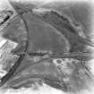
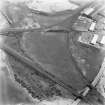
Traces of five Roman temporary camps, each defended by a slight ditch and rampart, have been observed on air photographs at Camelon. Two are described on NS88SE 7 and NS88SE 27. The other three (D, E, F on plan) consist of: Camp D, 290' N-S by a minimum of 480' E-W, which has been subdivided at some time, probably to make a smaller camp, by drawing a rampart and ditch across it from N-S, at a distance of about 230' from the W side. The crop marks are not sufficiently distinct to show the positions of any entrances into this camp.
Air photographs (CPE/Scot/UK 256: 5227-8) reveal the NW corner of camp E, immediately S of D, while traces of what may have been the N side of this camp may be seen intermittently on other APs (540/801: 3044-5). Faint indications of a possible continuation of the W side of the camp and the beginning of the SW corner appear on APs (DH 25-8 AAD 10).
It these markings all belong to the same work, as has been assumed on the plan, it would have measured 1450' N-S by not less than 1200' (c/f NS88SE 7).
RCAHMS 1963, visited 1958
The area covered by camp F has now been covered by a housing estate.
The St Joseph air photographs show clearly the whole of the W side, with a medial gateway protected by a tutulus, together with stretches of the N and S sides, each with a gate and tutulus. What appears to be the rounded NE corner of the ditch may be seen, and if this interpretation is correct, the camp will have measured about 530' N-S by 420', enclosing an area of 5 acres.
Visited by OS (JD) 1 February 1957
Vestiges of two ditches associated with these camps may be seen in the land now being quarried away to the W of Camelon N fort.
E J Price 1974
Photographed by the RCAHMS in 1977 and 1978. A possible Roman camp, centred NS 857 809, is also noted in 1977.
There are no surface traces of camps D and E in an undulating pasture field. Camps D, E, & F plotted on 1:2500 maps from aerial photographs.
Visited by OS (JRL) 15 April 1980
The western ditch of Camp 'F' was investigated during construction work for a car sales room. The flat-bottomed ditch had been heavily truncated by subsequent ploughing.
G B Bailey 1987.
Excavation for the Falkirk Museum was directed by G B Bailey. The west side of one of the groups of camps which are known from aerial photography to lie west of the fort was sought in advance of building-work north of the Glasgow Road. A small flat-bottomed ditch only 0.63m wide and 0.16m deep was all that had survived heavy ploughing. The ditch shelved up gradually towards the south and petered out only 6.9m after entering the excavation, failing to re-appear for at least 26m. This is too large a gap to be explained as a gateway and illustrates the destruction which ploughing can cause.
S S Frere 1988
NS 857 808 A 2.5m wide trench was excavated along the S side of the railway, behind the car sales room, in order to establish the lines of several temporary camp ditches seen on aerial photographs to the N. Two of the ditches which had been delineated on recent OS maps proved to be absent and inspection of the aerial photographs has concluded that they were not real. One ditch was, however, found at the extreme W end of the field. It was V-shaped, 3.4m wide and 1.2m deep, and ran on a N-S alignment. This is unusually large for such a camp.
Sponsor: Falkirk Museum
G B Bailey 1993.
NS 857 808. Excavation after soil-stripping revealed an interrelated series of ditches, much truncated by ploughing. No traces remained of any associated ramparts. Two possible kilns were also excavated.
L J F Keppie 1994.
Note (1978)
Camelon, Forts NS 863 810 NS88SE 22
Listed as temporary camps.
RCAHMS 1978
(Christison and Buchanan 1901; RCAHMS 1963, pp. 107-12, No. 122; DES, 1973, 52; DES, 1974, 63-4; DES, 1975, 52-3; DES, 1976, 61)
Publication Account (2008)
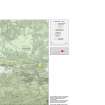
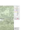
A 1:25000 scale map of the Antonine Wall was published by RCAHMS in 2008. The map shows the course of the Antonine Wall on a modern map base, including areas where the Wall is in public ownership or care and can be visited. The data had been collated as part of the project to prepare maps for the World Heritage Site nomination bid.
(17 December 2011)
South of the Lochlands Three Bridges area (see Lochlands, below), and now wholly under a housing estate, lies the camp of East Carmuirs, first recorded in 1949, prior to the construction of the houses (St Joseph 1951a: 62). It measured 163m from north to south by about 325m transversely, potentially enclosing around 5.5ha (13.6ha). It was originally believed to be small in size owing to a possible slight arc on the ditch on the north side possibly suggesting the north-east corner, which would mean that the camp enclosed some 2.1ha (5.1 acres) (Feachem 1958: 336–7; RCAHMS 1963: 111–2). However, reappraisal of the air photographs suggests a continuation of the south side, implying that the camp enclosed a much larger area. A gap on the west side may represent an entrance.
Publication Account (17 December 2011)
It is clear from the aerial and excavated evidence that the promontory represented not only a major gathering ground for troops on the march northwards, but also was a strategic location for the Antonine Wall. The presence of Flavian finds at both concentrations of camps on the promontory (including a Flavian radiocarbon date from charcoal in a pit group at Three Bridges: Bailey 2000: 483) attests to a certain amount of 1st century ad activity in the area, and is supported by the likely dating of the two camps at Lochlands with Stracathro-type gates. The denarius of Hadrian from Lochlands IV, while not comfortably
stratified, also attests to a later presence, possibly relating to the Antonine Wall and the fort of Camelon. Lying beyond the frontier, the area would have provided a greater level of security than many sites north of the Wall. While the finds assemblage is small, it is significant, particularly when placed in the context of artefacts from Roman camps (Hunter forthcoming).
The Lochlands area was clearly important in Roman times, probably both in terms of supplying the army and industrial activity, as well as being a nodal point for campaigns. It was clearly a major gathering ground for troops on the march northwards. The use of the Three Bridges area as a potential industrial zone may relate to a nearby port on the River Carron serving the fort at Camelon (Bailey 2000; Tatton-Brown 1980).
R H Jones.
Publication Account (17 December 2011)
In the area to the south of Lochlands, west of Camelon, lies a further series of camps known as ‘Three Bridges’; the majority lie in a triangular zone within three converging railway lines and have been recorded since the 1950s (RCAHMS 1963: 111). The area to the south of this triangle has been subject to several excavations in recent years by Bailey (Bailey 2000; Hunter 2003: 302). In addition, Price has recorded the ditches of possible camps just east of the railway triangle, north-west of the fort of Camelon, and these are probably the eastern part of one or more camps at Three Bridges, although some may relate to out-works for the fort (Price 1974; 1977). Camp fires were also found (Price and Price 1973), and one of the proposed camp ditches was up to 2.6m in width and up to 1.2m in depth (information in RCAHMS).
The results of Bailey’s excavations and the cropmark evidence suggests that at least six camps of varying shapes, sizes (and probably functions) have been recorded, along
with the camp known as East Carmuirs, which is probably larger than has previously been suspected (contra Feachem 1958: fig 6; RCAHMS 1963: fig 46 ‘F’).
Bailey’s excavations at Three Bridges have significantly expanded our knowledge of the camps in this area. Some of the camps excavated tied up with the known evidence from cropmarks; others represented new features. At least two of the camps may have been backfilled, one (probable camp VI) possibly to make way for a new camp in pretty much the same location (IV). Another showed evidence for recutting and therefore more than one phase of use (V). Potential annexes were also identified, and a series of pits excavated, identified as ovens and possibly kilns. Some of the ‘camps’ appeared to be 1st century ad in origin, owing to the identification of Flavian pottery in the ditch of camp IV. Bailey suggested that many of the ‘camps’ were probably work and stores depots, owing to the presence of pits indicating industrial activity at the site (2000). This also fits with the report of a series of ‘fire pits’ to the east of the railway, east of camp I, originally proposed as cremation pits (Breeze and Rich-Gray 1980). Presumably some of the Three Bridges camps may have related to the Antonine occupation of the area, but there is no datable evidence to confirm this at present.
Camp I is the north-eastern of the group between the three railway lines, and measures 80m by probably at least 115m, although the location of the east side is unknown and no entrances are visible. Camp II , to the west, may be an annexe to this small camp, or alternatively one of the two may represent a reduction of an existing camp. This second camp measures 83m by 70m, therefore enclosing almost 0.6ha (1.4 acres), although if the area of camp I is included then it measures about 82m by at least 180m. There are hints of a possible titulus on the north side, close to the ditch separating camps I and II.
Camp III lies immediately SSW of camp II and is almost square in form, measuring 57m by 56m, enclosing 0.3ha (0.8 acres). No gates have been recorded. To its east lies camp IV, now partially under an industrial estate. About 170m of its west side and 150m of the north have been recorded as cropmarks. The west side of this camp is often illustrated as running farther to the south (down to the west of the East Carmuirs camp, for example, Bailey 2000: illus. 1), but this could not be confirmed through the available air photographic evidence. Excavations by Bailey in 1987 and 1993 on the west ditch recorded that it was flat-bottomed, 0.63m wide and 0.16m deep and was heavily plough-truncated in one sector (Frere 1988: 426–7). In another, it was some 0.8m wide and 0.5m deep and may have been recut. An entrance gap was identified, with a narrow shallow ditch between, and some 8.2m to the west a truncated pit was located which was interpreted as the possible remnants of a titulus (Bailey 2000: 473–4). Flavian pottery was found in the ditch of this camp, and on the ground surface nearby (Bailey 2000: 487).
South of camp III and west of IV lie two sides of a further camp (V), again now partially under an industrial estate and housing. Some 65m of the north side, the rounded north-west corner angle and at least 140m of the west side have been recorded, the majority through aerial survey with excavations by Bailey recording a further stretch of the ditch to the south. He suggested, on topographical grounds, that the camp could measure some 420m in length, but also commented that it could represent part of an annexe or fort (2000: 483). The excavated ditch was up to 3.9m in width and 1.2m in depth and may have been deliberately backfilled. It also showed evidence for a recut (Keppie 1994: 257; Bailey 2000: 475–8). A series of pit groups were recovered, which produced artefacts and a radiocarbon date in the Flavian period. The excavator suggested that some may be ovens or kilns (Bailey 2000: 484–5).
R H Jones.
Publication Account (17 December 2011)
During excavations in 1993, Bailey recorded a ditch to the east of camp IV, of which at least 21m by 14m is known (Bailey 2000: 473. camp g). His trenches recorded the ditch was up to 0.8m wide and 0.55 deep. It may have been deliberately backfilled after a small amount of silting. He also recorded a further ditch to the west of the ditches of camps IV and VI, on an east-to-west alignment. This measured up to 1.2m in width and 0.5m in depth and may also have been deliberately backfilled (Bailey 2000: 474, camp h). This may represent the remains of a further camp of be an annexe to or reduction of an existing camp.
R H Jones.
Publication Account (17 December 2011)
South of the Lochlands Three Bridges area (see Lochlands, below), and now wholly under a housing estate, lies the camp of East Carmuirs, first recorded in 1949, prior to the construction of the houses (St Joseph 1951a: 62). It measured 163m from north to south by about 325m transversely, potentially enclosing around 5.5ha (13.6ha). It was originally believed to be small in size owing to a possible slight arc on the ditch on the north side possibly suggesting the north-east corner, which would mean that the camp enclosed some 2.1ha (5.1 acres) (Feachem 1958: 336–7; RCAHMS 1963: 111–2). However, reappraisal of the air photographs suggests a continuation of the south side, implying that the camp enclosed a much larger area. A gap on the west side may represent an entrance.
R H Jones
(17 December 2011)
South of the Lochlands Three Bridges area (see Lochlands, below), and now wholly under a housing estate, lies the camp of East Carmuirs, first recorded in 1949, prior to the construction of the houses (St Joseph 1951a: 62). It measured 163m from north to south by about 325m transversely, potentially enclosing around 5.5ha (13.6ha). It was originally believed to be small in size owing to a possible slight arc on the ditch on the north side possibly suggesting the north-east corner, which would mean that the camp enclosed some 2.1ha (5.1 acres) (Feachem 1958: 336–7; RCAHMS 1963: 111–2). However, reappraisal of the air photographs suggests a continuation of the south side, implying that the camp enclosed a much larger area. A gap on the west side may represent an entrance.
R H Jones

