 |
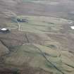
On-line Digital Images |
SC 1519272 |
RCAHMS Aerial Photography |
Blackhill and Mountcow, oblique aerial view, taken from the N, showing Blackhill enclosures in the bottom left-hand corner of the photograph, and Mountcow ironstone mine in the centre, to the right of Mountcow farmstead. |
1995 |
Item Level |
|
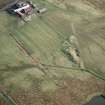 |
On-line Digital Images |
SC 1519275 |
RCAHMS Aerial Photography |
Mountcow, oblique aerial view, taken from the NW, showing Mountcow ironstone mine in ther centre of the photograph. |
1995 |
Item Level |
|
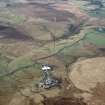 |
On-line Digital Images |
SC 1519277 |
RCAHMS Aerial Photography |
Blackhill and Mountcow, oblique aerial view, taken from the E, showing Blackhill enclosures in the bottom right-hand corner of the photograph, and Mountcow ironstone mine at the left-hand edge. |
1995 |
Item Level |
|
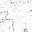 |
On-line Digital Images |
SC 2031901 |
Records of the Royal Commission on the Ancient and Historical Monuments of Scotland (RCAHMS), Edinbu |
Publication illustration: 'Extract from the first edition of the OS 6-inch map, showing the area to the west of Mountcow Farmsteading, Shotts (Lanarkshire 1864, sheet viii, surveyed 1859). |
1998 |
Item Level |
|
 |
On-line Digital Images |
SC 2432023 |
Records of the Ordnance Survey, Southampton, Hampshire, England |
Mountcow, NS86SW 6, Ordnance Survey index card, Recto |
1958 |
Item Level |
|


