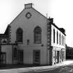
|
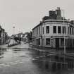
Photographs and Off-line Digital Images |
B 47555 |
|
View from North-West. |
16/7/1990 |
Item Level |
|
|
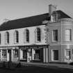
Photographs and Off-line Digital Images |
B 47556 CN |
|
View from North-West. |
16/7/1990 |
Item Level |
|
|
Photographs and Off-line Digital Images |
B 47557 |
|
View from North-East. |
16/7/1990 |
Item Level |
|
|
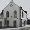
Photographs and Off-line Digital Images |
B 47558 CN |
|
View from North-East. |
16/7/1990 |
Item Level |
|
|
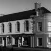
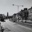
Photographs and Off-line Digital Images |
B 44894 |
|
View from South-East of High Street. |
1990 |
Item Level |
|
|
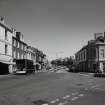
Photographs and Off-line Digital Images |
B 44895 |
|
View from West of High Street. |
1990 |
Item Level |
|
|
Photographs and Off-line Digital Images |
LA 2016 |
|
View from North-West of corner of High Street and Wellgate. |
1977 |
Item Level |
|
|
Photographs and Off-line Digital Images |
LA 2017 |
|
View from North-West of corner of High Street and Wellgate. |
1977 |
Item Level |
|
|
Prints and Drawings |
DC 29582 |
Records of the Royal Commission on the Ancient and Historical Monuments of Scotland (RCAHMS), Edinbu |
Site plan showing location of Lanark Parish Church and Town Hall.
Preparatory drawing for 'Tolbooths and Town-Houses', RCAHMS, 1996.
Signed: 'JB, HLG'
|
20/4/1991 |
Item Level |
|
 |
On-line Digital Images |
SC 336440 |
|
View from North-East. |
|
Item Level |
|
 |
On-line Digital Images |
SC 336441 |
|
View from North-West. |
|
Item Level |
|
 |
On-line Digital Images |
SC 2431783 |
Records of the Ordnance Survey, Southampton, Hampshire, England |
Lanark, High Street, Tolbooth, NS84SE 25, Ordnance Survey index card, Recto |
1958 |
Item Level |
|
 |
On-line Digital Images |
SC 2431784 |
Records of the Ordnance Survey, Southampton, Hampshire, England |
Lanark, High Street, Tolbooth, NS84SE 25, Ordnance Survey index card, Recto |
1958 |
Item Level |
|
 |
On-line Digital Images |
SC 2529345 |
|
View from South-East of High Street. |
1990 |
Item Level |
|
 |
On-line Digital Images |
SC 2529346 |
|
View from West of High Street. |
1990 |
Item Level |
|
 |
On-line Digital Images |
SC 2529348 |
|
View from North-West. |
16/7/1990 |
Item Level |
|
 |
On-line Digital Images |
SC 2529349 |
|
View from North-East. |
16/7/1990 |
Item Level |
|
 |
On-line Digital Images |
SC 2529350 |
|
View from North-East. |
16/7/1990 |
Item Level |
|
 |
On-line Digital Images |
SC 2529528 |
|
View from North-West of corner of High Street and Wellgate. |
1977 |
Item Level |
|
 |
On-line Digital Images |
SC 2529532 |
|
View from North-West of corner of High Street and Wellgate. |
1977 |
Item Level |
|
|
All Other |
551 166/1/1 |
Records of the Ordnance Survey, Southampton, Hampshire, England |
Archaeological site card index ('495' cards) |
1947 |
Sub-Group Level |
|


