Ledbeg River
Chambered Cairn (Neolithic)
Site Name Ledbeg River
Classification Chambered Cairn (Neolithic)
Alternative Name(s) Lyne
Canmore ID 4642
Site Number NC21SW 2
NGR NC 24891 14106
Datum OSGB36 - NGR
Permalink http://canmore.org.uk/site/4642
- Council Highland
- Parish Assynt
- Former Region Highland
- Former District Sutherland
- Former County Sutherland
NC21SW 2 2489 1411.
(NC 2489 1411) Chambered Cairn (NR)
OS 6"map, (1967)
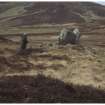
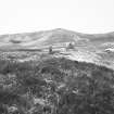
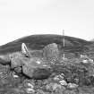
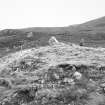
On the top of a knoll, just to the S of the road bridge over the Ledbeg River at Lyne, and about 50ft E of the road, are the remains of a large, circular chambered cairn, much dilapidated, and in great part removed. Three of the large upright blocks which have formed the sides and end of the chamber remain in situ, and a small stone protrudes between two of the larger ones at the NW. The two largest stones measure 4ft across the base, are 1ft 5 ins thick and 3ft to 4ft high. The diameter of the cairn has been about 36ft. The end stone of the chamber is about 23ft from the S edge. The side stones, which are slightly divergent, are 6ft apart.
RCAHMS 1911; A S Henshall 1963.
Only two stones of the chamber (the end and one side stone) now remain in situ but other large slabs lying prostrate nearby were obviously once part of it.
The mound is of earth and stone, about 1.3m high. The southern sector of the kerb ring remains.
Visited by OS (F R H) 6 June 1962.
No change to the previous field report.
Revised at 1:10,000.
Visited by OS (N K B) 1 September 1980.
Field Visit (11 June 1909)
11. Chambered Cairn, Ledbeg River. On the top of a knoll, just to the S. of the road bridge over the Ledbeg River at Lyne, and about 50' E. of the road, are the remains of a large circular cairn, much dilapidated, and in great part removed. Three of the large upright blocks which have formed the sides and end of the chamber remain in situ, and a small stone protrudes between two of the larger ones at the NW. The two largest stones measure 4' across the base, are 1' 5" thick, and 3' to 4' high. The diameter of the cairn has been about 36'. The end stone of the chamber is about 23' from the S. edge. The side stones, which are slightly divergent, are 6' apart.
OS 6-inch map, Sutherland, Sheet lxxxii. (unnoted).
RCAHMS 1911, visited (AOC) 11th June 1909.
Field Visit (28 November 2009)
Close to the bridge crossing the Ledbeg River and c.10m from the road, lies a cairn on a flat terrace. The cairn is approximately 9m in diameter and survives to a height of 1.5m on the north side, although two larger stones standing upright on the top take the height to almost 2m. It has suffered badly from robbing on its south side where a large depression is present and only the kerb stones survive. Major structural elements survive only on the north side where the majority of the cairn material appears undisturbed and several larger stones, up to 1m in size, are visible. The cairn is almost circular in plan and is mostly turfed over. There are no obvious entrance stones or lintels.
(HLP_ no 33)
Assynt's Hidden Lives Project 2009


