
Glendorch


Castle (Medieval), Tower House (Medieval)
Site Name Glendorch
Classification Castle (Medieval), Tower House (Medieval)
Canmore ID 46392
Site Number NS81NE 1
NGR NS 87070 18895
Datum OSGB36 - NGR
Permalink http://canmore.org.uk/site/46392


- Council South Lanarkshire
- Parish Crawfordjohn
- Former Region Strathclyde
- Former District Clydesdale
- Former County Lanarkshire
NS81NE 1 8706 1889.
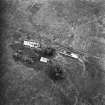
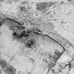
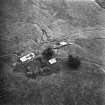
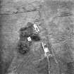
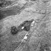
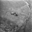
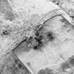
(NS 8706 1889) Castle (NR) (remains of)
OS 6" map (1961)
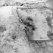
The remains of a border peel or tower may be seen at Glendorch.
G V Irving and A Murray 1864
The remains of a tower are incorporated in a barn at Glendorch.
NSA 1845
The whole of the S wall of the barn contains the springing of a barrel vault 2.5 m high and 1.2 m thick. Part of the tower projects W from the barn, 2.5 m high near its wall, but elsewhere mainly as turf-covered foundations. In the S wall of the barn is a splayed aperture. The overall dimensions of the structure have been 16.4 by 6.8 m. From the existing remains, this tower appears to have been of 16th century date.
Visited by OS (WDJ) 16 July 1959
Photographed by the RCAHM in 1980.

