|
Photographs and Off-line Digital Images |
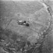
LA 2911 |
RCAHMS Aerial Photography |
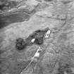
Aerial view. |
1980 |
Item Level |
|
|
Photographs and Off-line Digital Images |
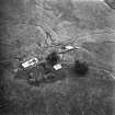
LA 2912 |
RCAHMS Aerial Photography |
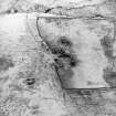
Aerial view. |
1980 |
Item Level |
|
|
Photographs and Off-line Digital Images |
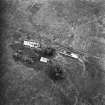
LA 2913 |
RCAHMS Aerial Photography |
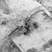
Aerial view. |
1980 |
Item Level |
|
|
Photographs and Off-line Digital Images |
LA 2914 |
RCAHMS Aerial Photography |
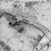
Aerial view. |
1980 |
Item Level |
|
|
Photographs and Off-line Digital Images |
LA 2915 |
RCAHMS Aerial Photography |
Aerial view. |
1980 |
Item Level |
|
|
Photographs and Off-line Digital Images |
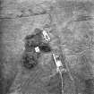
D 60748 |
RCAHMS Aerial Photography |
Oblique aerial view centred on the remains of the farmstead, field banks, rig and tower-house, taken from the ESE. |
27/3/2000 |
Item Level |
|
|
Photographs and Off-line Digital Images |
D 60749 |
RCAHMS Aerial Photography |
Oblique aerial view centred on the remains of the farmstead, field banks, rig and tower-house, taken from the ENE. |
27/3/2000 |
Item Level |
|
|
Photographs and Off-line Digital Images |
D 60750 |
RCAHMS Aerial Photography |
Oblique aerial view centred on the remains of the farmstead, field banks, rig and tower-house, taken from the N. |
27/3/2000 |
Item Level |
|
 |
On-line Digital Images |
SC 1683802 |
RCAHMS Aerial Photography |
Aerial view. |
1980 |
Item Level |
|
 |
On-line Digital Images |
SC 1683803 |
RCAHMS Aerial Photography |
Aerial view. |
1980 |
Item Level |
|
 |
On-line Digital Images |
SC 1683804 |
RCAHMS Aerial Photography |
Aerial view. |
1980 |
Item Level |
|
 |
On-line Digital Images |
SC 1683805 |
RCAHMS Aerial Photography |
Aerial view. |
1980 |
Item Level |
|
 |
On-line Digital Images |
SC 1683806 |
RCAHMS Aerial Photography |
Aerial view. |
1980 |
Item Level |
|
 |
On-line Digital Images |
SC 1725747 |
RCAHMS Aerial Photography |
Oblique aerial view centred on the remains of the farmstead, field banks, rig and tower-house, taken from the ESE. |
27/3/2000 |
Item Level |
|
 |
On-line Digital Images |
SC 1725748 |
RCAHMS Aerial Photography |
Oblique aerial view centred on the remains of the farmstead, field banks, rig and tower-house, taken from the ENE. |
27/3/2000 |
Item Level |
|
 |
On-line Digital Images |
SC 1725749 |
RCAHMS Aerial Photography |
Oblique aerial view centred on the remains of the farmstead, field banks, rig and tower-house, taken from the N. |
27/3/2000 |
Item Level |
|
 |
On-line Digital Images |
SC 2431426 |
Records of the Ordnance Survey, Southampton, Hampshire, England |
Glendorch, NS81NE 1, Ordnance Survey index card, page number 1, Recto |
1958 |
Item Level |
|
 |
On-line Digital Images |
SC 2431427 |
Records of the Ordnance Survey, Southampton, Hampshire, England |
Glendorch, NS81NE 1, Ordnance Survey index card, page number 2, Verso |
1958 |
Item Level |
|
 |
On-line Digital Images |
SC 2431428 |
Records of the Ordnance Survey, Southampton, Hampshire, England |
Glendorch, NS81NE 1, Ordnance Survey index card, Recto |
1958 |
Item Level |
|
|
All Other |
551 166/1/1 |
Records of the Ordnance Survey, Southampton, Hampshire, England |
Archaeological site card index ('495' cards) |
1947 |
Sub-Group Level |
|


