
Stirling, King's Park


Cup And Ring Marked Rock (Neolithic) - (Bronze Age)
Site Name Stirling, King's Park
Classification Cup And Ring Marked Rock (Neolithic) - (Bronze Age)
Canmore ID 46180
Site Number NS79SE 16
NGR NS 78384 93001
Datum OSGB36 - NGR
Permalink http://canmore.org.uk/site/46180


- Council Stirling
- Parish Stirling
- Former Region Central
- Former District Stirling
- Former County Stirlingshire
NS79SE 16 783 930.
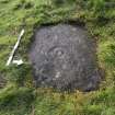
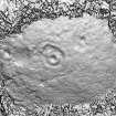
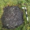
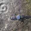
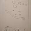
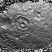
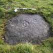
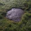
(NS 783 930) There is a cup and ring mark on a small, flat, ground level outcrop of rock near the crest of the steep craggy slope along the SW side of the King's Park. It is 45 yds E of a seat which is NNW of Douglas Terrace. On the flat rock surface, whick measures 2'6" x 1'6", is a cup, 1 1/2" in diameter and 1/2" deep, surrounded by a ring 5" in diameter, and another ring 9" in diameter, now much weathered.
RCAHMS 1963, visited 1958
Morris notes a cup mark on either side of the mark described above.
R W B Morris 1969
This cup and ring marked rock, which lies on a golf course, could not be located.
Visited by OS (JP) 10 January 1974
Note (1979)
King’s Park, Stirling NS 783 930 NS79SE 16
This rock outcrop bears three cup-marks, one of which has two concentric rings.
RCAHMS 1979
(RCAHMS 1963, p. 65; no. 42; Morris 1968, 73, no. 182)
Note (9 October 2020)
Date Fieldwork Started: 09/10/2020
Compiled by: ELF
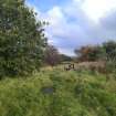
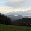
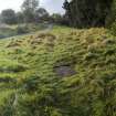
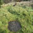
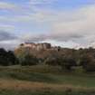
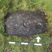
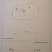
Location Notes: The panel is situated in woodland lying flat on level ground at the top of an escarpment that slopes steeply to the S. It is located 10m W of a memorial bench and 7m N of tarmac track which runs to the S of Kings Park Golf Course. Previous descriptions describe the stone as being 45m from a bench so it appears that a new bench has been put in place. The location (if the surrounding trees were removed) would have panoramic views to the crag and tail of Stirling Castle and the Ochil Hills to the NE, towards the Ben Ledi and the Trossachs to the W, and across the escarpment to the Gargunnock Hills to the SW.
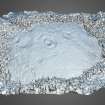
Panel Notes: This is a small sandstone boulder measuring 1.0 x 0.7m flush with the ground and with a flat upper surface. It features 1 cup with 2 rings, the outer ring being very faint, and 2 cups each with faint single rings barely discernable in the field but visible on 3D imagery. There is a depression in the panel between the eastern-most and central motifs which may be natural.

