|
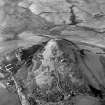
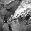
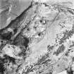
Photographs and Off-line Digital Images |
B 71522 |
RCAHMS Aerial Photography |
Oblique aerial view. |
1991 |
Item Level |
|
|
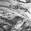
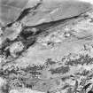
Photographs and Off-line Digital Images |
B 71524 |
RCAHMS Aerial Photography |
Oblique aerial view. |
1991 |
Item Level |
|
|
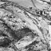
Photographs and Off-line Digital Images |
B 71526 |
RCAHMS Aerial Photography |
Oblique aerial view. |
1991 |
Item Level |
|
|
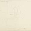
Prints and Drawings |
STD 36/2 |
Records of the Royal Commission on the Ancient and Historical Monuments of Scotland (RCAHMS), Edinbu |
Plane-table survey; fort, Myot Hill. |
7/5/1953 |
Item Level |
|
|
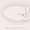
Prints and Drawings |
STD 36/3 |
Records of the Royal Commission on the Ancient and Historical Monuments of Scotland (RCAHMS), Edinbu |
Plan of Myot Hill fort. Alternative version. |
c. 1960 |
Item Level |
|
|
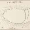
Prints and Drawings |
STD 36/1 |
Records of the Royal Commission on the Ancient and Historical Monuments of Scotland (RCAHMS), Edinbu |
Publication drawing; fort, Myot Hill. |
c. 1953 |
Item Level |
|
|
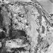
Photographs and Off-line Digital Images |
B 71525 |
RCAHMS Aerial Photography |
Oblique aerial view. |
1991 |
Item Level |
|
|
Photographs and Off-line Digital Images |
B 71523 |
RCAHMS Aerial Photography |
Oblique aerial view. |
1991 |
Item Level |
|
|
Photographs and Off-line Digital Images |
E 23392 |
RCAHMS Aerial Photography |
Oblique aerial view centred on the radio station and the remains of the fort with the quarry adjacent, taken from the SE. |
17/12/2002 |
Item Level |
|
|
Photographs and Off-line Digital Images |
E 23393 |
RCAHMS Aerial Photography |
Oblique aerial view centred on the radio station and the remains of the fort with the quarry adjacent, taken from the E. |
17/12/2002 |
Item Level |
|
|
Photographs and Off-line Digital Images |
E 23394 |
RCAHMS Aerial Photography |
Oblique aerial view centred on the radio station and the remains of the fort with the quarry adjacent, taken from the NW. |
17/12/2002 |
Item Level |
|
|
Photographs and Off-line Digital Images |
E 23395 |
RCAHMS Aerial Photography |
Oblique aerial view centred on the radio station and the remains of the fort with the quarry adjacent, taken from the SW. |
17/12/2002 |
Item Level |
|
 |
On-line Digital Images |
SC 1108337 |
RCAHMS Aerial Photography |
Oblique aerial view centred on the radio station and the remains of the fort with the quarry adjacent, taken from the E. |
17/12/2002 |
Item Level |
|
|
Manuscripts |
MS 36/179 |
Records of the Royal Commission on the Ancient and Historical Monuments of Scotland (RCAHMS), Edinbu |
Field notebook of R W Feachem (RCAHMS), 1951-54. Notes on sites in Stirlingshire, Roxburghshire, Peebles-shire, Renfrewshire, Clackmannanshire, Ross and Cromarty, Banffshire, Dumfries-shire and Lanarkshire. |
1951 |
Item Level |
|
 |
On-line Digital Images |
DP 203954 |
Records of the Royal Commission on the Ancient and Historical Monuments of Scotland (RCAHMS), Edinbu |
Publication drawing; fort, Myot Hill. |
c. 1953 |
Item Level |
|
 |
On-line Digital Images |
DP 203955 |
Records of the Royal Commission on the Ancient and Historical Monuments of Scotland (RCAHMS), Edinbu |
Plane-table survey; fort, Myot Hill. |
7/5/1953 |
Item Level |
|
 |
On-line Digital Images |
DP 203956 |
Records of the Royal Commission on the Ancient and Historical Monuments of Scotland (RCAHMS), Edinbu |
Plan of Myot Hill fort. Alternative version. |
c. 1960 |
Item Level |
|
 |
On-line Digital Images |
SC 1669819 |
RCAHMS Aerial Photography |
Oblique aerial view centred on the radio station and the remains of the fort with the quarry adjacent, taken from the NW. |
17/12/2002 |
Item Level |
|
 |
On-line Digital Images |
SC 1669820 |
RCAHMS Aerial Photography |
Oblique aerial view centred on the radio station and the remains of the fort with the quarry adjacent, taken from the SW. |
17/12/2002 |
Item Level |
|
 |
On-line Digital Images |
SC 1725416 |
RCAHMS Aerial Photography |
Oblique aerial view. |
1991 |
Item Level |
|
 |
On-line Digital Images |
SC 1725417 |
RCAHMS Aerial Photography |
Oblique aerial view. |
1991 |
Item Level |
|
 |
On-line Digital Images |
SC 1725418 |
RCAHMS Aerial Photography |
Oblique aerial view. |
1991 |
Item Level |
|
 |
On-line Digital Images |
SC 1725419 |
RCAHMS Aerial Photography |
Oblique aerial view. |
1991 |
Item Level |
|
 |
On-line Digital Images |
SC 1725420 |
RCAHMS Aerial Photography |
Oblique aerial view. |
1991 |
Item Level |
|


