
Antonine Wall, Bar Hill Roman Fort


Bath House (Roman), Roman Fort (Roman), Temporary Camp (Roman)(Possible)
Site Name Antonine Wall, Bar Hill Roman Fort
Classification Bath House (Roman), Roman Fort (Roman), Temporary Camp (Roman)(Possible)
Canmore ID 45920
Site Number NS77NW 8
NGR NS 70746 75926
Datum OSGB36 - NGR
Permalink http://canmore.org.uk/site/45920


First 100 images shown. See the Collections panel (below) for a link to all digital images.
- Council East Dunbartonshire
- Parish Kirkintilloch (Strathkelvin)
- Former Region Strathclyde
- Former District Strathkelvin
- Former County Dunbartonshire
NS77NW 8 707 759.
NS77NW 8 NS 70746 75926 Roman Fort (R) Well (R)
OS 6" map (1968)
In 1895 an altar to Silvanus, believed to have come from a small shrine outside the fort, was discovered on Bar Hill. The altar, now lodged in the Hunterian Musem, Glasgow, is 3 feet in height, and a translation of its inscription reads: "Erected to the God Silvanus by Caristanius Iustianus, praefect of the first cohort of Hamii, in willing payment of a vow." This cohort of archers was stationed at Carvoran in A.D.135 or 136. In the same year a plough struck three large stones, which could have formed part of the W gateway or some associated building. Thorough excavtions were carried out during 1903-4, organised by Mr. Whitelaw of Gartshore. Within the second century camp of Lollius Urbicus, which measures 399 feet by 393 feet, an almost perfect square surrounded by a rampart composed of sods, a smaller first century camp measuring 191 feet by 160 feet is to be seen. This latter construction may have been carried out by Agricola.
Within the camp are latrines, 'rows of post-holes' which may be an indication of the quarters of the soldiers, and also heating apparatus which would have been utilised for then baths. A well nearby yielded many artefacts, including a bag containing workmen's tools, many shoes and sandals, a wooden comb, piece of rope, arrow-heads, 'some 60 linear ft. of pillars,' one of which has a carved capital, and two stones bearing inscriptions indicating that auxiliaries form Lower Germany were manning the fort. Additionally there was a good deal of pottery, ballista balls, a copper pot, a bell, a compass leg, four 'rude stone busts,' walnuts, hazel nuts, oyster shells, 'bones and skeleton heads of the short-horned Celtic ox and a few coins. These coins supported the theory that the 'vallum was abandoned in the reign of Commodus.' There were also thirteen denarii, which were dicovered to be made out of tin and consequently not actual money, merely tokens for 'devotional purposes.'
Rel and Illust Arch 12 1906.
The Antonine fort on the summit of Bar Hill, 495' (148) OD, measured 369' (112.5m) N-S by 375' (114.3m) internally, giving an area of 3.18 acres (1.29 hectares). It was defended by a turf rampart 12' wide at the base, and by two ditches on the E, S and W sides, but only one ditch on the N side. The two W ditches, the rounded NW corner and a culvert piercing the N rampart, E of the NW corner, may all still be seen, despite the undergrowth of the wood.
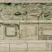
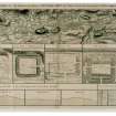
It was excavated by Macdonald and Park from 1902-5; inside the fort were found the remains of the Headquarters building, a granary and another stone building, all in the central block, besides a bath-house inside the NW angle, and also a water tank, streets, postholes of wooden barrack blocks (many with the stumps of posts still in them), and several pits. The most impressive of all the structural remains were those of the well, in the courtyard of the Headquarters building. It was 43' deep and 4' in diameter, and was steined or "cradled" all the way down with shaped stones. Original Roman stones from the well have been used to rebuild the present well-mouth. A very great number of small finds were made, particularly in the well. They are fully described by A S Robertson, M Scott and L Keppie (1975).
No traces were found of an annexe linked to the fort defences, during the excavations. In 1908 an outlying ditch was located to the S of the fort, but its alignment has not been recorded; at about the same time the depression belonging to what was interpreted as a ditch was noticed W of the fort, but was notbtested by excavation. Nothing more is known about the purpose or date of either. Limited excavation and chance finds have combined to indicate that an extra-mural settlement, perhaps of considerable size, lay to the E of the fort, in Castlehill Park. It may have taken the form of ribbon development along the Military Way. Underlying the Antonine fort, there was located the ditch system of a long-axis rectangular fortlet, with an annexe to the W. This was most probably of Flavian date.
With the exception of an altar in the NMAS, all the surviving finds are in the Hunterian Museum, Glasgow.
A S Robertson 1973; G Macdonald 1934; G Macdonald and A Park 1906
The area of Bar Hill Roman fort is defined by a scarped slope, averaging 1.5m in height, and traceable all round except on the south side, amid dense vegetation and trees. The rounded north west angle is fairly well defined by the spoil mound of the ditches, but elsewhere there is no trace of ditches or rampart. A well defined causeway, 5m wide, emits from the east side of the fort. Of the internal structures, the outline of the bath house can be defined by the course of a slight wall giving an area of about 28m x 5m. A number of large dressed stones lie within the bath-house, as well as the few erect pillars of a hypocaust, and the remains of a culvert.
The well remains filled with water and debris, and measures roughly 1.2m in diameter. A modern revetment wall surrounds it. No other internal structures were found, but on the south side of the fort, a stretch of cobbling with a facing kerb stones runs for 58m along what would appear to be the course of the rampart; this is possibly the base of the rampart.
Visited by OS (JLD) 14 January 1957
None of the supposedly Flavian structures which Macdonald and others claim to have identified on the line of the Antonine Wall can be unequivocally accepted. (cf Croy Hill: NS77NW 10, Cadder: NS67SW 16).
RCAHMS 1978
In 1974 and 1976 many Roman finds discovered in fields to the south, south west and east of the fort included much pottery and tile/brick, fragments of a glass bottle, part of a bronze statuette, fragments of sheet bronze, and red clay gaming balls. Some of these finds are in the Hunterian Museum.
In 1978 and 1979 the fort bath house and latrine block, overall 38m long and 5.5m wide, and the rear range of rooms of the headquarters building (principia) were re-excavated for permanent display. The east-west dimension of the headquarters was 24.3m with the 3 rear rooms, the centre one of which was identified as the regimental chapel, all showing two phase floor levels and dressed sandstone walling, surviving to a height of up to 4 courses. Terracing had been required to accommodate the building on this side (south) of Bar Hill. The inter vallum street adjacent to the bathhouse and roadways along the west, south and east sides of the headquarters were also investigated. Many small finds confirmed a mid 2nd century date for the site.
A ditch of the suggested earlier "fortlet" underlying the fort was sectioned, and although no finds were made an Agricolan date is now thought doubtful, especially in view of excavation results of a similar enclosure at Croy Hill (cf NS77NW 10).
Excavation is likely to resume in 1980.
J J Walker 1974; L J F Keppie 1978; 1979; R Goodburn 1979; DES 1976
The fort is generally as described the defences, being poorly preserved except around the north west angle. The bath house, part of the headquarter building and the well are open to display, with excavation of the headquarter area having been resumed (June/July 1980).
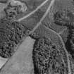
There is no surface trace of the Military Way crossing the north front of the fort and its course from the causewayed east entrance is obscured by mature afforestation.
Fort, bath house, headquarters buildings and well re-surveyed at 1:2500.
Visited by OS (JRL) 4 July 1980
Excavation in 1980 concentrated on the crosshall area of the headquarters building and the underlying "fortlet" ditches. The crosshall measured internally 21.8m by 6.7m with clay flooring and a later tribunal inserted in the south west corner. North of the crosshall lay a rectangular courtyard 21.8m by 11m internally with post pits suggesting a sequence of lean-to structures against its east and south sides. A recent circular stone platform and path around the well head was removed.
Further sectioning of the underlying "fortlet" produced no further dating evidence, but proved an internal rampart, circa 2.5m wide.
L Keppie 1980
A denarius of Antoninus Pius (AD 140-3) was found in the spoil-heaps from the 1979-81 excavations.
J D Bateson 1990
Pottery kiln.
D J Breeze 1987
Wooden objects in Hunterian Museum:
Turned box with lid (Salix sp.) F1936:104
Staves (14) from casks (Quercus sp.) F1936:98
Cask ends (Quercus sp.) F1936:99, 100, 101, 102
Bobbin with thread attached.
Double-sided comb. F1936:105
Handles. F1936:106, 108
C Earwood 1993.
NS 706 759. A geophysical survey was conducted in the field immediately to the W of the Bar Hill Roman site. This was to confirm the route of the Antonine Rampart and to test whether evidence of possible extensions of the wall-base, projecting to the S, could be detected. Significant variation in resistivity did occur at several zones (each possibly extending about 4m to the S) along the southern edge of the wall-base. Also S of the wall, the Military Way (4-4.5m wide) appears to run about 8m distant but possibly converging towards the wall near the western gate of the field.
A Strang and J Walker 1995.
This fort, at 150m above sea level the highest one on the line, was noted by antiquaries at an early stage, some time in the latter part of the 17th century. Between 1902 and 1905 there were extensive excavations undertaken and following this Historic Scotland and its predecessors cleared trees and much undergrowth to make it more possible to understand the earthworks which survived, including some of the refuse pits.The bath-house and headquarters building were reopened during excavations carried out between 1978 and 1982.
The defences of the fort, which had an internal area of 3.2 acres, comprised a turf rampart which measured 3.6m in width at its base and also two ditches on three of the sides and one on the N side. Short detached sections of ditch masked the E and S gates, and at the W gate there was no interruption of the two W ditches. As the Wall did not form any part of the fortifications, the fort possessed rounded corners. A number of features can still be distinguisned today, including the E ditch and a causeway leading to the E gateway, the two ditches on the W, the rounded corner in the NW and also a notable stone-lined culvert which traverses the N rampart, close to the NE corner.
There are a number of features visible within the fort. In the central block are the remains of the headquartes building, constructed of stone, a granary and another building and in the NW angle there can be seen the bath-house. Also discernible are streets, several pits, a water tank, plus posthole from the blocks of wooden barracks ( with post stumps in many of them).
The headquartes building, which held a central position facing on to the via principalis, was almost square, measuring 23.5 by 25.5m.Today only a 'few courses of walling' and the 'foundation cobbling' are visible. Formerly an open courtyard would be traversed initially by the visitor, then a 'covered crosshall,' possessing a dais at the W end. behind this were three offices. The 'shrine of the standards' was probably situated in the cetnre of the range at the rear, where a stone-lined strongbox was discovered 'set into the floor.' A later development during a secondary phase, situated in the W half of the courtyard, was a timber store building. It is now believed that the building's north facade rather than its front courtyard was the location for the stone columns discovered in 1902 in the wellin the courtyard, which constituted one of the earliest finds on the first day excavation took place in 1902. The well, which was 13m deep and had a diameter of 1.2m, had shaped stones 'steining'or 'cradling' it for the whole of its depth. The present well-mouth has been constructed from original Roman stones discovered inside the well, which proved a rich source of artefacts. The finds included an altar as well as 'three fragments of a building inscription, both set up by the First Cohort of Baetasians. additionally there were building stones, more than twenty columns with bases and cpaitals, wooden beams, ballista balls, the iron hoops from the well-bucket, a section of the pulley associated with the well, articles made out of leather, many iron tools and weapons, shells and animal bones, bronze ornaments and thirteen coins. Ten of these were made out of tin, from moulds rather than being struck, and probalby locaaly made to be thrown into the well as offerings.
The 1902-5 excavations confirmed, through the discovery of fragments of bows and also arrowheads, the previously believed presence of the First Cohort of Hamians, who were Syrian archers, attested by the finding of an altar to Silvanus and a tombstone. Building activity by detachments of the Second and Twentieth Legions have also been recorded.
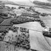
The location of the discovery of the altar to Silvanus, ploughed up in a field, was about 215m NE of the E entrance to the fort. The shrine had probalbly been erected outwith the fort. The existence of 'substantial extra-mural settlement' in the area was indicated by the discovery of many potsherds and also fireplaces.
On the 'forward slope of the hill' was the bath-house, situated just behind the N rampart and close to its NW corner. From the W a series of small rooms would have been entered and it has been observed that there was more than one structural phase involved. There would have been an undressing room, with nearby latrine, then a cold room, followed by a 'small heated range.' It would appear that the 'visible hypocausted apartment' was added at a later date. At the E end of the range was a furnace which a capstone from the stoking passage now marks. At a later date still, presumably after the building had ceased being used for its original function, a small pottery kiln had been inserted into the N side of the furnace room. It would seem that the potter was of a North African background due to the nature of the artefacts produced.
The 1902-5 excavations had indentified a small, underlying enclosure at the very apex of the hill, measuring 1.5 acres within its enclosing ditches, and this was reinvestigated between 1978 and 1982. Turf and hawthorn brushwood had been used deliberately to fill in the ditches. It would seem likely that this feature constituted a small encampment utilised by the men constructing the Wall and its associated installations. On the ground the general outline of this encampment is still visible.
The report of the 1902-5 excavations mentioned a ditch located to the S of the fort, as well as another to the W. Another ditch, to the S of the fort, was revealed by aerial phorography, and excavation undertaken betwwen 1982 and 1984 would suggest that these features represent a small temporary camp.
Anne S. Robertson/Lawrence Keppie 2001.
NS 7073 7592 A magnetic survey of nearly 3ha was conducted to the W, S and E of the fort in May 2006. Weak anomalies appeared immediately W of the fort which are unlikely to relate to Roman structures. From the SW corner of the fort a ditch continued westwards, following the course of the modern pathway to the site. In the field to the S and SW of the field several anomalies were detected, some of them due to 19th-century industrial workings, others perhaps relating to the fort. Two small areas were investigated in wooded land on the E side of the fort.
Location of archive to be determined.
Sponsor: EU Culture 2000
Richard Jones, 2006.
Artefact Recovery (1895)
In the 1895 year a plough struck three large stones, which could have formed part of the W gateway or some associated building.
Excavation (1902 - 1905)
NS77NW 8 NS 70746 75926 Roman Fort (R) Well (R)
OS 6" map (1968)
In 1895 an altar to Silvanus, believed to have come from a small shrine outside the fort, was discovered on Bar Hill. The altar, now lodged in the Hunterian Musem, Glasgow, is 3 feet in height, and a translation of its inscription reads: "Erected to the God Silvanus by Caristanius Iustianus, praefect of the first cohort of Hamii, in willing payment of a vow." This cohort of archers was stationed at Carvoran in A.D.135 or 136. In the same year a plough struck three large stones, which could have formed part of the W gateway or some associated building. Thorough excavtions were carried out during 1903-4, organised by Mr. Whitelaw of Gartshore. Within the second century camp of Lollius Urbicus, which measures 399 feet by 393 feet, an almost perfect square surrounded by a rampart composed of sods, a smaller first century camp measuring 191 feet by 160 feet is to be seen. This latter construction may have been carried out by Agricola.
Within the camp are latrines, 'rows of post-holes' which may be an indication of the quarters of the soldiers, and also heating apparatus which would have been utilised for then baths. A well nearby yielded many artefacts, including a bag containing workmen's tools, many shoes and sandals, a wooden comb, piece of rope, arrow-heads, 'some 60 linear ft. of pillars,' one of which has a carved capital, and two stones bearing inscriptions indicating that auxiliaries form Lower Germany were manning the fort. Additionally there was a good deal of pottery, ballista balls, a copper pot, a bell, a compass leg, four 'rude stone busts,' walnuts, hazel nuts, oyster shells, 'bones and skeleton heads of the short-horned Celtic ox and a few coins. These coins supported the theory that the 'vallum was abandoned in the reign of Commodus.' There were also thirteen denarii, which were dicovered to be made out of tin and consequently not actual money, merely tokens for 'devotional purposes.'
Rel and Illust Arch 12 1906.
The Antonine fort on the summit of Bar Hill, 495' (148) OD, measured 369' (112.5m) N-S by 375' (114.3m) internally, giving an area of 3.18 acres (1.29 hectares). It was defended by a turf rampart 12' wide at the base, and by two ditches on the E, S and W sides, but only one ditch on the N side. The two W ditches, the rounded NW corner and a culvert piercing the N rampart, E of the NW corner, may all still be seen, despite the undergrowth of the wood.
It was excavated by Macdonald and Park from 1902-5; inside the fort were found the remains of the Headquarters building, a granary and another stone building, all in the central block, besides a bath-house inside the NW angle, and also a water tank, streets, postholes of wooden barrack blocks (many with the stumps of posts still in them), and several pits. The most impressive of all the structural remains were those of the well, in the courtyard of the Headquarters building. It was 43' deep and 4' in diameter, and was steined or "cradled" all the way down with shaped stones. Original Roman stones from the well have been used to rebuild the present well-mouth. A very great number of small finds were made, particularly in the well. They are fully described by A S Robertson, M Scott and L Keppie (1975).
Field Visit (14 January 1957)
The area of Bar Hill Roman fort is defined by a scarped slope, averaging 1.5m in height, and traceable all round except on the south side, amid dense vegetation and trees. The rounded north west angle is fairly well defined by the spoil mound of the ditches, but elsewhere there is no trace of ditches or rampart. A well defined causeway, 5m wide, emits from the east side of the fort. Of the internal structures, the outline of the bath house can be defined by the course of a slight wall giving an area of about 28m x 5m. A number of large dressed stones lie within the bath-house, as well as the few erect pillars of a hypocaust, and the remains of a culvert.
The well remains filled with water and debris, and measures roughly 1.2m in diameter. A modern revetment wall surrounds it. No other internal structures were found, but on the south side of the fort, a stretch of cobbling with a facing kerb stones runs for 58m along what would appear to be the course of the rampart; this is possibly the base of the rampart.
Visited by OS (JLD) 14 January 1957
Photographic Record (8 February 1967)
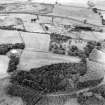
Aerial Photography (1971)
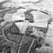
Oblique aerial photographs taken by Mr John Dewar in 1971.
Artefact Recovery (1974 - 1976)
In 1974 and 1976 many Roman finds discovered in fields to the south, south west and east of the fort included much pottery and tile/brick, fragments of a glass bottle, part of a bronze statuette, fragments of sheet bronze, and red clay gaming balls. Some of these finds are in the Hunterian Museum.
Photographic Record (1974)
Aerial Photography (1974)
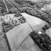
Oblique aerial photographs taken by Mr John Dewar in 1974.
Publication Account (1978)
None of the supposedly Flavian structures which Macdonald and others claim to have identified on the line of the Antonine Wall can be unequivocally accepted. (cf Croy Hill: NS77NW 10, Cadder: NS67SW 16).
RCAHMS 1978
Excavation (1978 - 1982)
In 1978 and 1979 the fort bath house and latrine block, overall 38m long and 5.5m wide, and the rear range of rooms of the headquarters building (principia) were re-excavated for permanent display. The east-west dimension of the headquarters was 24.3m with the 3 rear rooms, the centre one of which was identified as the regimental chapel, all showing two phase floor levels and dressed sandstone walling, surviving to a height of up to 4 courses. Terracing had been required to accommodate the building on this side (south) of Bar Hill. The inter vallum street adjacent to the bathhouse and roadways along the west, south and east sides of the headquarters were also investigated. Many small finds confirmed a mid 2nd century date for the site.
A ditch of the suggested earlier "fortlet" underlying the fort was sectioned, and although no finds were made an Agricolan date is now thought doubtful, especially in view of excavation results of a similar enclosure at Croy Hill (cf NS77NW 10).
Excavation is likely to resume in 1980.
J J Walker 1974; L J F Keppie 1978; 1979; R Goodburn 1979; DES 1976
Excavation in 1980 concentrated on the crosshall area of the headquarters building and the underlying "fortlet" ditches. The crosshall measured internally 21.8m by 6.7m with clay flooring and a later tribunal inserted in the south west corner. North of the crosshall lay a rectangular courtyard 21.8m by 11m internally with post pits suggesting a sequence of lean-to structures against its east and south sides. A recent circular stone platform and path around the well head was removed.
Further sectioning of the underlying "fortlet" produced no further dating evidence, but proved an internal rampart, circa 2.5m wide.
L Keppie 1980
Aerial Photography (31 July 1979)
Artefact Recovery (1979 - 1981)
A denarius of Antoninus Pius (AD 140-3) was found in the spoil-heaps from the 1979-81 excavations.
J D Bateson 1990
Field Visit (4 July 1980)
The fort is generally as described the defences, being poorly preserved except around the north west angle. The bath house, part of the headquarter building and the well are open to display, with excavation of the headquarter area having been resumed (June/July 1980).
There is no surface trace of the Military Way crossing the north front of the fort and its course from the causewayed east entrance is obscured by mature afforestation.
Fort, bath house, headquarters buildings and well re-surveyed at 1:2500.
Visited by OS (JRL) 4 July 1980
Note (1982)
Bar Hill, Fort NS 707 759 NS77NW 8
This fort, situated at a height of 145m OD near the summit of Bar Hill, is the highest of the forts on the Antonine Wall. Unlike all the others, it is not attached to the Rampart, standing apart on slightly higher ground, some 35m to the S. It measured 115m by 112m (1.3ha) internally and, when excavated in 1902, was found to overlie an earlier enclosure of semi-permanent character. The latter structure, measuring about 56m by 45m over the rampart, is now thought to be of early Antonine date, and it probably fulfilled a purpose similar to that of the pre-fort enclosure on Croy Hill. The bath-house and headquarters building of the fort are being conserved for public display.
RCAHMS 1982
(Macdonald and Park 1906; Robertson, Scott and Keppie 1975; DES 1978, 30; DES, 1979, 40; Keppie 1979; DES, 1980, 36-7; DES, 1981, 40-1)
Resistivity (May 1995)
NS 706 759. A geophysical survey was conducted in the field immediately to the W of the Bar Hill Roman site. This was to confirm the route of the Antonine Rampart and to test whether evidence of possible extensions of the wall-base, projecting to the S, could be detected. Significant variation in resistivity did occur at several zones (each possibly extending about 4m to the S) along the southern edge of the wall-base. Also S of the wall, the Military Way (4-4.5m wide) appears to run about 8m distant but possibly converging towards the wall near the western gate of the field.
A Strang and J Walker 1995.
Publication Account (2001)
This fort, at 150m above sea level the highest one on the line, was noted by antiquaries at an early stage, some time in the latter part of the 17th century. Between 1902 and 1905 there were extensive excavations undertaken and following this Historic Scotland and its predecessors cleared trees and much undergrowth to make it more possible to understand the earthworks which survived, including some of the refuse pits.The bath-house and headquarters building were reopened during excavations carried out between 1978 and 1982.
The defences of the fort, which had an internal area of 3.2 acres, comprised a turf rampart which measured 3.6m in width at its base and also two ditches on three of the sides and one on the N side. Short detached sections of ditch masked the E and S gates, and at the W gate there was no interruption of the two W ditches. As the Wall did not form any part of the fortifications, the fort possessed rounded corners. A number of features can still be distinguisned today, including the E ditch and a causeway leading to the E gateway, the two ditches on the W, the rounded corner in the NW and also a notable stone-lined culvert which traverses the N rampart, close to the NE corner.
There are a number of features visible within the fort. In the central block are the remains of the headquartes building, constructed of stone, a granary and another building and in the NW angle there can be seen the bath-house. Also discernible are streets, several pits, a water tank, plus posthole from the blocks of wooden barracks ( with post stumps in many of them).
The headquartes building, which held a central position facing on to the via principalis, was almost square, measuring 23.5 by 25.5m.Today only a 'few courses of walling' and the 'foundation cobbling' are visible. Formerly an open courtyard would be traversed initially by the visitor, then a 'covered crosshall,' possessing a dais at the W end. behind this were three offices. The 'shrine of the standards' was probably situated in the cetnre of the range at the rear, where a stone-lined strongbox was discovered 'set into the floor.' A later development during a secondary phase, situated in the W half of the courtyard, was a timber store building. It is now believed that the building's north facade rather than its front courtyard was the location for the stone columns discovered in 1902 in the wellin the courtyard, which constituted one of the earliest finds on the first day excavation took place in 1902. The well, which was 13m deep and had a diameter of 1.2m, had shaped stones 'steining'or 'cradling' it for the whole of its depth. The present well-mouth has been constructed from original Roman stones discovered inside the well, which proved a rich source of artefacts. The finds included an altar as well as 'three fragments of a building inscription, both set up by the First Cohort of Baetasians. additionally there were building stones, more than twenty columns with bases and cpaitals, wooden beams, ballista balls, the iron hoops from the well-bucket, a section of the pulley associated with the well, articles made out of leather, many iron tools and weapons, shells and animal bones, bronze ornaments and thirteen coins. Ten of these were made out of tin, from moulds rather than being struck, and probalby locaaly made to be thrown into the well as offerings.
The 1902-5 excavations confirmed, through the discovery of fragments of bows and also arrowheads, the previously believed presence of the First Cohort of Hamians, who were Syrian archers, attested by the finding of an altar to Silvanus and a tombstone. Building activity by detachments of the Second and Twentieth Legions have also been recorded.
The location of the discovery of the altar to Silvanus, ploughed up in a field, was about 215m NE of the E entrance to the fort. The shrine had probalbly been erected outwith the fort. The existence of 'substantial extra-mural settlement' in the area was indicated by the discovery of many potsherds and also fireplaces.
On the 'forward slope of the hill' was the bath-house, situated just behind the N rampart and close to its NW corner. From the W a series of small rooms would have been entered and it has been observed that there was more than one structural phase involved. There would have been an undressing room, with nearby latrine, then a cold room, followed by a 'small heated range.' It would appear that the 'visible hypocausted apartment' was added at a later date. At the E end of the range was a furnace which a capstone from the stoking passage now marks. At a later date still, presumably after the building had ceased being used for its original function, a small pottery kiln had been inserted into the N side of the furnace room. It would seem that the potter was of a North African background due to the nature of the artefacts produced.
The 1902-5 excavations had indentified a small, underlying enclosure at the very apex of the hill, measuring 1.5 acres within its enclosing ditches, and this was reinvestigated between 1978 and 1982. Turf and hawthorn brushwood had been used deliberately to fill in the ditches. It would seem likely that this feature constituted a small encampment utilised by the men constructing the Wall and its associated installations. On the ground the general outline of this encampment is still visible.
The report of the 1902-5 excavations mentioned a ditch located to the S of the fort, as well as another to the W. Another ditch, to the S of the fort, was revealed by aerial phorography, and excavation undertaken betwwen 1982 and 1984 would suggest that these features represent a small temporary camp.
Anne S. Robertson/Lawrence Keppie 2001.
Resistivity (22 March 2006 - 20 June 2006)
NS 7073 7592 A magnetic survey of nearly 3ha was conducted to the W, S and E of the fort in May 2006. Weak anomalies appeared immediately W of the fort which are unlikely to relate to Roman structures. From the SW corner of the fort a ditch continued westwards, following the course of the modern pathway to the site. In the field to the S and SW of the field several anomalies were detected, some of them due to 19th-century industrial workings, others perhaps relating to the fort. Two small areas were investigated in wooded land on the E side of the fort.
Location of archive to be determined.
Sponsor: EU Culture 2000
Richard Jones, 2006.
Magnetometry (22 May 2006 - 20 June 2006)
NS 7073 7592 A magnetic survey of nearly 3ha was conducted to the W, S and E of the fort in May 2006. Weak anomalies appeared immediately W of the fort which are unlikely to relate to Roman structures. From the SW corner of the fort a ditch continued westwards, following the course of the modern pathway to the site. In the field to the S and SW of the field several anomalies were detected, some of them due to 19th-century industrial workings, others perhaps relating to the fort. Two small areas were investigated in wooded land on the E side of the fort.
Location of archive to be determined.
Sponsor: EU Culture 2000
Richard Jones, 2006.
Magnetometry (20 May 2006 - 20 June 2006)
NS 7073 7592 A magnetic survey of nearly 3ha was conducted to the W, S and E of the fort in May 2006. Weak anomalies appeared immediately W of the fort which are unlikely to relate to Roman structures. From the SW corner of the fort a ditch continued westwards, following the course of the modern pathway to the site. In the field to the S and SW of the field several anomalies were detected, some of them due to 19th-century industrial workings, others perhaps relating to the fort. Two small areas were investigated in wooded land on the E side of the fort.
Location of archive to be determined.
Sponsor: EU Culture 2000
Richard Jones, 2006.
Publication Account (2008)
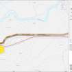
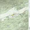
A 1:25000 scale map of the Antonine Wall was published by RCAHMS in 2008. The map shows the course of the Antonine Wall on a modern map base, including areas where the Wall is in public ownership or care and can be visited. The data had been collated as part of the project to prepare maps for the World Heritage Site nomination bid.
Publication Account (17 December 2011)
The Roman fort on Bar Hill was excavated between 1902 and 1905. During these excavations, what was interpreted as an ‘Early Fort’ was uncovered lying underneath the Antonine Fort (Macdonald and Park 1906: 11–15). The site of the fort itself lies on the top of Bar Hill, at the highest point for any fort on the Antonine Wall. Just to the east lies the presumed Iron Age fort on Castle Hill, but the site commands good views to the north as well as along the Antonine Wall to east and west.
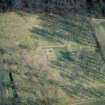
The first excavations of that ‘Early Fort’ recorded its unusual plan, much of which can be traced on the ground today as a shallow depression: an inner rectangular enclosure measuring about 58m from north-east to southwest by 49m, enclosing some 0.28ha (0.7 acres); an annexe to the south-west; and outer ditches on the south-east, north-east and north-west sides, with part of the northwest side undetected. The inner enclosure has a single entrance gap in the centre of the north-east side, and there is a staggered entrance to the north of this in the outer ditch. The excavations on the line of the ditch confirmed that it was V-shaped, ranging in width from 2.4m to 3.3m and in depth from 1.1m to 1.4m. The excavators noted that the absence of finds suggested a brief occupation; and the presence of about 0.6m of silt in the ditches prior to the building of the fort suggested that the site had long been abandoned. This led to the interpretation of the siteas one of the Agricolan praesidia on the Forth and Clyde isthmus (Macdonald and Park 1906: 15, 129–30). (It was a further 70 years before the probable Flavian fortlet of Mollins was discovered by aerial survey, about 4km due south of Bar Hill (RCAHMS 1978a: 160).)
Excavations between 1978 and 1982 by Keppie agreed with the outline of the ‘fortlet’ but did not agree with its interpretation as a Flavian outpost. Steer had earlier noted that the site might relate to the construction of the Antonine Wall owing to its similarity to other Antonine sites, including the fortlet at Duntocher (1960: 90). Feachem suggested that the remains may represent Iron Age activity, although this has not generally garnered favour (Robertson et al 1975: 8; Keppie 1985: 52). Keppie’s excavations gave similar ditch dimensions to those noted earlier, of 2m in width and 1.2m in depth on the south side, although this was not consistent throughout and the ditch was recorded as U-shaped and unusual in places. A rampart of yellow clay was also recorded on the southeast side, some 2.2m in width and 0.2m in height. In addition, various activities were noted in the interior that were assumed to be contemporary with the ‘fortlet’, including areas of burning (with a hearth of at least two periods) and areas of cobbling. A depression and channel cut through its rampart to reach the ditch, and Roman pot lids of Antonine date, as well as fragments of Iron Age pottery and hobnails, were recovered from this feature. The ditches were deliberately filled with turf and hawthorn brushwood, probably when the Antonine fort was under construction.
The ‘fortlet’ is generally interpreted as a construction camp for the Wall (Robertson and Keppie 2001: 93) or a semi-permanent Antonine site housing perhaps the garrison for a nearby (as yet undiscovered) fortlet (also see Croy Hill) (Hanson and Maxwell 1986: 120). No Flavian finds have been found on the Hill.
One further possibility should be noted – that this enclosure, sited on the highest point of the Wall close to the midpoint, could have housed a garrison engaged in surveying the Wall, with perhaps another garrison housed at the nearby enclosure underneath the fort on Croy Hill, some 3km to the east.
R H Jones.
Note (April 2017)
Bathhouses
Roman forts were provided with bathhouses (balnea) for the soldiers. These are often located just outside a fort, in an annexe (enclosed area attached to a fort), or inside but close to the edge. They were away from the main buildings because of the fire risk that they posed. This was because bathhouses had hot rooms heated by a hypocaust system - underfloor heating provided by a furnace.
Bathhouses contained several rooms (Bearsden had eight, Bothwellhaugh seven, Bar Hill around six), which were usually entered in a sequence, the bather returning the same way. Not all rooms were present in every bathhouse, but could include:
* Changing room, where a soldier would remove his clothes (but keep footwear on – the floors could get very hot!)
* Cold room (Frigidarium)
* Cold plunge bath
* Warm rooms (Tepidaria)
* Hot room (Caldarium)
* Hot bath
The furnace room (praefurnium) sat beyond the hot rooms.
Turkish baths are the closest modern-day parallel to Roman bathhouses. We don’t know how often men bathed nor how frequently water was changed in the baths - they were probably used by around 500 men! They used a curved metal blade, known as a strigil, to scrape oil and dirt from the skin in a hot room or after exercise (http://collections.gla.ac.uk/#details=ecatalogue.123109). It is possible that they relaxed and played games in the bathhouses – a gaming board was found in the granary at Bearsden. Excavations in the bathhouse there also found a sandstone head of a goddess (https://vimeo.com/129135972) and a fountainhead with a gaping mouth – all are now on display in the Hunterian Museum.
Excavations in the cold room at Bothwellhaugh revealed an attractive floral drain cover, with the water draining away between the petals. This is now in the Hunterian Museum (http://collections.gla.ac.uk/#details=ecatalogue.125932).
Latrines
And of course, soldiers need to go to the toilet! But this was a communal activity, with toilet blocks seating several soldiers together. A number of latrines have been found in Scotland. At Castlecary, excavations in 1902 revealed the toilet block separate from the bathhouse, but flushed by drains from the fort. These took the sewage through the wall of the fort and outside into the ditches.
At Bearsden, the toilet had nine seats – stone seats with holes have been found, but excavations on Hadrian’s Wall have found wooden seats so they presumably had wooden seats on top – rather warmer to sit on than stone in the winter months! Underneath the seats, the sewage channel was flushed by water from the bathhouse, showing careful and sensible design. Moss was found in the sewage, suggesting that soldiers used this to clean themselves in the toilet. The sewage from the latrine at Bearsden drained through the rampart and into the ditches, where it could still be smelt whilst being excavated almost 2,000 years later.
Dr Rebecca Jones - Head of Archaeology and World Heritage

