
Bar Hill


Temporary Camp (Roman)
Site Name Bar Hill
Classification Temporary Camp (Roman)
Canmore ID 45899
Site Number NS77NW 32
NGR NS 70700 75750
Datum OSGB36 - NGR
Permalink http://canmore.org.uk/site/45899


- Council East Dunbartonshire
- Parish Kirkintilloch (Strathkelvin)
- Former Region Strathclyde
- Former District Strathkelvin
- Former County Dunbartonshire
NS77NW 32 70700 75750
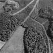
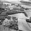
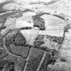
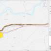
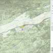
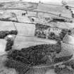
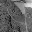
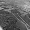
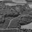
Situated immediately S of the Roman fort on Bar Hill (NS77NW 8). First noted on aerial photographs and confirmed by excavation. The ditch on the E side has been located; this turned W short of the fort, but the N side could be traced for only 25m, beyond which it may have been destroyed by mine-working or have turned. The S side, indicated on aerial photographs, was marked by a hollow not certainly man-made, and the W side could not be located. The topography suggests an enclosure of c.0.6ha (1.48 acres), but the camp could have extended further to W and S.
RCAHMS 1982; L Keppie and J Walker 1982; 1983; S Frere 1985
Excavation took place between October 1982 and February 1984. The ditch was located without difficulty as the S end can be seen as a shallow dip. The ditch, 2m wide and 0.5 to 0.7m deep, runs to the NW (towards the fort) before turning at right angles to the W, where it was followed for 25m; thereafter its course could not be established. The ditch may have been disturbed by mine workings as a pit shaft is visible nearby and a spread of cinders and coal was found overlying the natural clay in trenches close to this disturbance. It seemed reasonable to conclude that the ditch formed part of the defences of a temporary camp lying immediately SW of the fort (NS77NW 8).
L J F Keppie and J J Walker 1990
Excavation (October 1982 - February 1984)
Excavation took place between October 1982 and February 1984. The ditch was located without difficulty as the S end can be seen as a shallow dip. The ditch, 2m wide and 0.5 to 0.7m deep, runs to the NW (towards the fort) before turning at right angles to the W, where it was followed for 25m; thereafter its course could not be established. The ditch may have been disturbed by mine workings as a pit shaft is visible nearby and a spread of cinders and coal was found overlying the natural clay in trenches close to this disturbance. It seemed reasonable to conclude that the ditch formed part of the defences of a temporary camp lying immediately SW of the fort (NS77NW 8).
L J F Keppie and J J Walker 1990
Note (1982)
Bar Hill NS 707 757 NS77NW
Cropmarks reveal a ditch running from N to S across the field immediately S of the Roman fort on Bar Hill (NS77NW 8).
RCAHMS 1982
Publication Account (2008)
A 1:25000 scale map of the Antonine Wall was published by RCAHMS in 2008. The map shows the course of the Antonine Wall on a modern map base, including areas where the Wall is in public ownership or care and can be visited. The data had been collated as part of the project to prepare maps for the World Heritage Site nomination bid.
Publication Account (17 December 2011)
The probable camp on Bar Hill was first recorded from the air by RCA HMS in 1979 (Maxwell and Wilson 1987:29), and subsequently confirmed by excavation (Keppie and Walker 1990: 151–3). It lies on the same ridge as the fort on Bar Hill, in the arable field immediately to the south.
The camp was recorded as a linear cropmark running NNW to SSE near the south corner of the fort, and part of the possible SSE side could be detected. However, excavations failed to locate the SSE side, suggesting that the linear cropmark originally identified on this side might be the result of a natural hollow. The ditch on the ENE side is at least 135m long and measured about 2m in width by up to 0.7m in depth, with the corner on the north side and some 25m of the NN W side traced by excavation. The presumed continuation of the side could not be established, owing to probable later industrial workings. Its overall size is unknown, although Keppie and Walker estimated that it could enclose 0.6ha (1.48 acres)based on the local topography (1990: 153).
The camp was initially interpreted as a possible annexe to the fort, but was demonstrated to turn west rather than join up to the fort’s defences. The excavators noted that it could be the same feature (ditch) that George Macdonald recorded having been opened up in 1908 (Macdonald 1911: 199; 1934: 281).
It is perhaps curious that the camp appears to enclose ground to the south-west of the fort rather than the slight knoll immediately to the south, which appears to be slightly more suitable ground, and certainly commands a better outlook. This choice of location to the rear of the fort adds weight to the theory that this was a construction camp for the building of the fort (Keppie and Walker 1990: 153).
R H Jones 2011

