 |
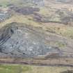
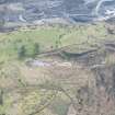
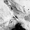
On-line Digital Images |
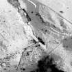
SC 355759 |
RCAHMS Aerial Photography |
Aerial view |
1984 |
Item Level |
|
 |
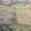
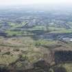
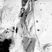
On-line Digital Images |
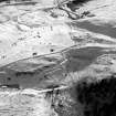
SC 355760 |
RCAHMS Aerial Photography |
Aerial view |
1984 |
Item Level |
|
 |
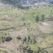
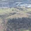
On-line Digital Images |
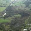
DP 020989 |
RCAHMS Aerial Photography Digital |
General oblique aerial view centred on the course of the Antonine Wall and the quarry with the site of the Roman fortlet adjacent, taken from the SW. |
8/9/2006 |
Item Level |
|
 |
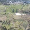
On-line Digital Images |
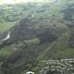
DP 020990 |
RCAHMS Aerial Photography Digital |
General oblique aerial view centred on the course of the Antonine Wall and the quarry with the site of the Roman fortlet adjacent, taken from the WSW. |
8/9/2006 |
Item Level |
|
 |
On-line Digital Images |
DP 249544 |
Historic Environment Scotland |
Oblique aerial view. |
24/3/2017 |
Item Level |
|
 |
On-line Digital Images |
DP 249545 |
Historic Environment Scotland |
Oblique aerial view. |
24/3/2017 |
Item Level |
|
 |
On-line Digital Images |
DP 249551 |
Historic Environment Scotland |
Oblique aerial view. |
24/3/2017 |
Item Level |
|
 |
On-line Digital Images |
DP 249552 |
Historic Environment Scotland |
Oblique aerial view. |
24/3/2017 |
Item Level |
|
 |
On-line Digital Images |
DP 249553 |
Historic Environment Scotland |
Oblique aerial view. |
24/3/2017 |
Item Level |
|
 |
On-line Digital Images |
DP 249554 |
Historic Environment Scotland |
Oblique aerial view. |
24/3/2017 |
Item Level |
|
 |
On-line Digital Images |
DP 249555 |
Historic Environment Scotland |
Oblique aerial view. |
24/3/2017 |
Item Level |
|
 |
On-line Digital Images |
SC 1725241 |
RCAHMS Aerial Photography |
Aerial view |
1984 |
Item Level |
|
 |
On-line Digital Images |
SC 1725397 |
RCAHMS Aerial Photography |
Aerial view |
1984 |
Item Level |
|
 |
On-line Digital Images |
SC 1725401 |
RCAHMS Aerial Photography |
Aerial view |
1984 |
Item Level |
|
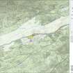 |
On-line Digital Images |
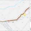
SC 1926557 |
Records of Historic Scotland, Edinburgh, Scotland |
Map 5 of 8 from IV.I 1-8 - Series 1: Maps of the Antonine Wall at a scale of 1:25000 showing the proposed World Heritage Site, known forts and fortlets, camps, other features and the buffer zones. Maps were prepared for the nomination document to propose the extension of the Frontiers of the Roman Empire World Heritage Site through the addition of the Antonine Wall. |
2006 |
Item Level |
|
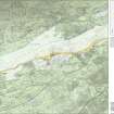 |
On-line Digital Images |
SC 1927886 |
Records of Historic Scotland, Edinburgh, Scotland |
Map 5 of 8 from IV.2 1-8 - Series 2: Maps of the Antonine Wall at a scale of 1:25000 showing the proposed World Heritage Site, known forts and fortlets, camps, other features and the buffer zones. Maps were prepared for the nomination document to propose the extension of the Frontiers of the Roman Empire World Heritage Site through the addition of the Antonine Wall. |
2006 |
Item Level |
|
 |
On-line Digital Images |
SC 1929349 |
Records of Historic Scotland, Edinburgh, Scotland |
Map 21 of 39 from Series V. Maps of the Antonine Wall and its known features at a scale of 1:5000 showing the scheduled areas and the proposed World Heritage Site. Maps were prepared for the nomination document to propose the extension of the Frontiers of the Roman Empire World Heritage Site through the addition of the Antonine Wall. |
2006 |
Item Level |
|
 |
On-line Digital Images |
SC 1970706 |
Records of Historic Scotland, Edinburgh, Scotland |
Antonine Wall 1:25000 broadsheet map |
2008 |
Item Level |
|
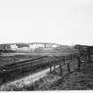 |
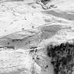
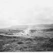
On-line Digital Images |
SC 2009939 |
Historic Scotland Photographic Library |
Croy Roman Wall Views |
29/4/1971 |
Item Level |
|
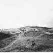 |
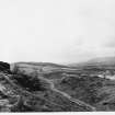
On-line Digital Images |
SC 2009940 |
Historic Scotland Photographic Library |
Croy Roman Wall Views |
29/4/1971 |
Item Level |
|
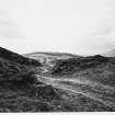 |
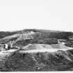
On-line Digital Images |
SC 2009941 |
Historic Scotland Photographic Library |
Croy Roman Wall Views |
29/4/1971 |
Item Level |
|
 |
On-line Digital Images |
SC 2009942 |
Historic Scotland Photographic Library |
Croy Roman Wall Views |
29/4/1971 |
Item Level |
|
 |
On-line Digital Images |
SC 2009943 |
Historic Scotland Photographic Library |
Croy Roman Wall Views |
29/4/1971 |
Item Level |
|
 |
On-line Digital Images |
SC 2009944 |
Historic Scotland Photographic Library |
Croy Roman Wall Views |
29/4/1971 |
Item Level |
|


