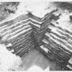
|
All Other |
551 490/1/2/6/8/1/1 |
Historic Scotland Photographic Library |
Roman Wall, Croy Hill Section of Fort, Cumbernauld, Dumbartonshire. General Views |
|
Item Level |
|
|
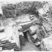
All Other |
551 490/1/2/6/8/1/2 |
Historic Scotland Photographic Library |
Roman Wall, Croy Hill Section of Fort, Cumbernauld, Dumbartonshire. General Views |
|
Item Level |
|
|
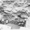
All Other |
551 490/1/2/6/8/1/3 |
Historic Scotland Photographic Library |
Roman Wall, Croy Hill Section of Fort, Cumbernauld, Dumbartonshire. General Views |
|
Item Level |
|
 |
On-line Digital Images |
SC 2009991 |
Historic Scotland Photographic Library |
Roman Wall, Croy Hill Section of Fort, Cumbernauld, Dumbartonshire. General Views |
|
Item Level |
|
 |
On-line Digital Images |
SC 2009992 |
Historic Scotland Photographic Library |
Roman Wall, Croy Hill Section of Fort, Cumbernauld, Dumbartonshire. General Views |
|
Item Level |
|
 |
On-line Digital Images |
SC 2009993 |
Historic Scotland Photographic Library |
Roman Wall, Croy Hill Section of Fort, Cumbernauld, Dumbartonshire. General Views |
|
Item Level |
|
|
Digital Files (Non-image) |
GV 008531 |
Records of Historic Scotland, Edinburgh, Scotland |
Map showing the Antonine Wall, the World Heritage Site area, the areas of the World Heritage Site in public ownership or care, the Buffer Zone and the Council boundaries. Created for the World Heritage Site nomination - Management plan. |
2006 |
Item Level |
|
 |
On-line Digital Images |
SC 2170806 |
Records of Historic Scotland, Edinburgh, Scotland |
Map showing the Antonine Wall, the World Heritage Site area, the areas of the World Heritage Site in public ownership or care, the Buffer Zone and the Council boundaries. Created for the World Heritage Site nomination - Management plan. |
2006 |
Item Level |
|
 |
On-line Digital Images |
SC 2430471 |
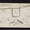
Records of the Ordnance Survey, Southampton, Hampshire, England |
Antonine Wall, Croy Hill Roman Fort, NS77NW 10, Ordnance Survey index card, page number 1, Recto |
1958 |
Item Level |
|
 |
On-line Digital Images |
SC 2430472 |
Records of the Ordnance Survey, Southampton, Hampshire, England |
Antonine Wall, Croy Hill Roman Fort, NS77NW 10, Ordnance Survey index card, page number 2, Verso |
1958 |
Item Level |
|
 |
On-line Digital Images |
SC 2430473 |
Records of the Ordnance Survey, Southampton, Hampshire, England |
Antonine Wall, Croy Hill Roman Fort, NS77NW 10, Ordnance Survey index card, page number 3, Recto |
1958 |
Item Level |
|
 |
On-line Digital Images |
SC 2430474 |
Records of the Ordnance Survey, Southampton, Hampshire, England |
Antonine Wall, Croy Hill Roman Fort, NS77NW 10, Ordnance Survey index card, page number 4, Verso |
1958 |
Item Level |
|
 |
On-line Digital Images |
SC 2430475 |
Records of the Ordnance Survey, Southampton, Hampshire, England |
Antonine Wall, Croy Hill Roman Fort, NS77NW 10, Ordnance Survey index card, page number 2, Recto |
1958 |
Item Level |
|
 |
On-line Digital Images |
SC 2430476 |
Records of the Ordnance Survey, Southampton, Hampshire, England |
Antonine Wall, Croy Hill Roman Fort, NS77NW 10, Ordnance Survey index card, page number 3, Recto |
1958 |
Item Level |
|
 |
On-line Digital Images |
SC 2430477 |
Records of the Ordnance Survey, Southampton, Hampshire, England |
Antonine Wall, Croy Hill Roman Fort, NS77NW 10, Ordnance Survey index card, Recto |
1958 |
Item Level |
|
 |
On-line Digital Images |
SC 2430478 |
Records of the Ordnance Survey, Southampton, Hampshire, England |
Antonine Wall, Croy Hill Roman Fort, NS77NW 10, Ordnance Survey index card, Recto |
1958 |
Item Level |
|
 |
On-line Digital Images |
SC 2430479 |
Records of the Ordnance Survey, Southampton, Hampshire, England |
Antonine Wall, Croy Hill Roman Fort, NS77NW 10, Ordnance Survey index card, Recto |
1958 |
Item Level |
|
 |
On-line Digital Images |
SC 2430480 |
Records of the Ordnance Survey, Southampton, Hampshire, England |
Antonine Wall, Croy Hill Roman Fort, NS77NW 10, Ordnance Survey index card, Recto |
1958 |
Item Level |
|
 |
On-line Digital Images |
SC 2430481 |
Records of the Ordnance Survey, Southampton, Hampshire, England |
Antonine Wall, Croy Hill Roman Fort, NS77NW 10, Ordnance Survey index card, Recto |
1958 |
Item Level |
|
 |
On-line Digital Images |
SC 2430482 |
Records of the Ordnance Survey, Southampton, Hampshire, England |
Antonine Wall, Croy Hill Roman Fort, NS77NW 10, Ordnance Survey index card, page number 1, Recto |
1958 |
Item Level |
|
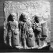 |
On-line Digital Images |
SC 2475429 |
|
Sculptured relief in RMS, Queen Street |
1965 |
Item Level |
|
|
All Other |
551 490/1/2/6/8/1 |
Historic Scotland Photographic Library |
Roman Wall, Croy Hill Section of Fort, Cumbernauld, Dumbartonshire. General Views |
|
Batch Level |
|
|
All Other |
551 166/1/1 |
Records of the Ordnance Survey, Southampton, Hampshire, England |
Archaeological site card index ('495' cards) |
1947 |
Sub-Group Level |
|
|
All Other |
551 490/1/2/6/8 |
Historic Scotland Photographic Library |
Croy Hill Roman Fort, Cumbernauld, North Lanarkshire |
|
Sub-Group Level |
|


