 |
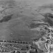
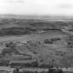
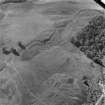
On-line Digital Images |
SC 1776203 |
John Dewar |
Oblique aerial view |
1971 |
Item Level |
|
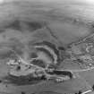 |
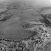
On-line Digital Images |
SC 1776204 |
John Dewar |
Oblique aerial view |
1971 |
Item Level |
|
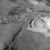 |
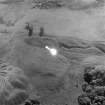
On-line Digital Images |
SC 1776205 |
John Dewar |
Oblique aerial view |
1971 |
Item Level |
|
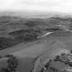 |
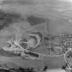
On-line Digital Images |
SC 1776206 |
John Dewar |
Oblique aerial view |
1971 |
Item Level |
|
 |
On-line Digital Images |
SC 1776207 |
John Dewar |
Oblique aerial view |
1971 |
Item Level |
|
 |
On-line Digital Images |
SC 1776208 |
John Dewar |
Oblique aerial view |
1971 |
Item Level |
|
 |
On-line Digital Images |
SC 1776209 |
John Dewar |
Oblique aerial view |
1971 |
Item Level |
|
 |
On-line Digital Images |
SC 1776210 |
John Dewar |
Oblique aerial view |
1971 |
Item Level |
|
 |
On-line Digital Images |
SC 1776211 |
John Dewar |
Oblique aerial view |
1971 |
Item Level |
|
 |
On-line Digital Images |
SC 1776212 |
John Dewar |
Oblique aerial view |
1971 |
Item Level |
|
 |
On-line Digital Images |
SC 1776213 |
John Dewar |
Oblique aerial view |
1971 |
Item Level |
|
|
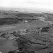
Photographs and Off-line Digital Images |
SC 1912399 |
Cambridge University Collection for Aerial Photography |
Aerial view |
|
Item Level |
|
|
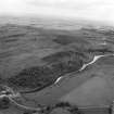
Photographs and Off-line Digital Images |
SC 1912400 |
Cambridge University Collection for Aerial Photography |
Aerial view |
|
Item Level |
|
|
Photographs and Off-line Digital Images |
SC 1916136 |
Cambridge University Collection for Aerial Photography |
Aerial view |
|
Item Level |
|
|
Photographs and Off-line Digital Images |
SC 1916137 |
Cambridge University Collection for Aerial Photography |
Aerial view |
|
Item Level |
|
|
Digital Files (Non-image) |
GV 007521 |
Records of Historic Scotland, Edinburgh, Scotland |
Map 5 of 8 from IV.I 1-8 - Series 1: Maps of the Antonine Wall at a scale of 1:25000 showing the proposed World Heritage Site, known forts and fortlets, camps, other features and the buffer zones. Maps were prepared for the nomination document to propose the extension of the Frontiers of the Roman Empire World Heritage Site through the addition of the Antonine Wall. |
2006 |
Item Level |
|
 |
On-line Digital Images |
SC 1926557 |
Records of Historic Scotland, Edinburgh, Scotland |
Map 5 of 8 from IV.I 1-8 - Series 1: Maps of the Antonine Wall at a scale of 1:25000 showing the proposed World Heritage Site, known forts and fortlets, camps, other features and the buffer zones. Maps were prepared for the nomination document to propose the extension of the Frontiers of the Roman Empire World Heritage Site through the addition of the Antonine Wall. |
2006 |
Item Level |
|
|
Digital Files (Non-image) |
GV 007528 |
Records of Historic Scotland, Edinburgh, Scotland |
Map 5 of 8 from IV.2 1-8 - Series 2: Maps of the Antonine Wall at a scale of 1:25000 showing the proposed World Heritage Site, known forts and fortlets, camps, other features and the buffer zones. Maps were prepared for the nomination document to propose the extension of the Frontiers of the Roman Empire World Heritage Site through the addition of the Antonine Wall. |
2006 |
Item Level |
|
 |
On-line Digital Images |
SC 1927886 |
Records of Historic Scotland, Edinburgh, Scotland |
Map 5 of 8 from IV.2 1-8 - Series 2: Maps of the Antonine Wall at a scale of 1:25000 showing the proposed World Heritage Site, known forts and fortlets, camps, other features and the buffer zones. Maps were prepared for the nomination document to propose the extension of the Frontiers of the Roman Empire World Heritage Site through the addition of the Antonine Wall. |
2006 |
Item Level |
|
|
Digital Files (Non-image) |
GV 007554 |
Records of Historic Scotland, Edinburgh, Scotland |
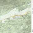
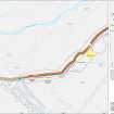
Map 21 of 39 from Series V. Maps of the Antonine Wall and its known features at a scale of 1:5000 showing the scheduled areas and the proposed World Heritage Site. Maps were prepared for the nomination document to propose the extension of the Frontiers of the Roman Empire World Heritage Site through the addition of the Antonine Wall. |
2006 |
Item Level |
|
 |
On-line Digital Images |
SC 1929349 |
Records of Historic Scotland, Edinburgh, Scotland |
Map 21 of 39 from Series V. Maps of the Antonine Wall and its known features at a scale of 1:5000 showing the scheduled areas and the proposed World Heritage Site. Maps were prepared for the nomination document to propose the extension of the Frontiers of the Roman Empire World Heritage Site through the addition of the Antonine Wall. |
2006 |
Item Level |
|
|
Digital Files (Non-image) |
GV 007595 |
Records of Historic Scotland, Edinburgh, Scotland |
Antonine Wall 1:25000 broadsheet map - created in three sections - this is the central section of the map |
2008 |
Item Level |
|
 |
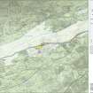
On-line Digital Images |
SC 1970706 |
Records of Historic Scotland, Edinburgh, Scotland |
Antonine Wall 1:25000 broadsheet map |
2008 |
Item Level |
|
|
Digital Files (Non-image) |
TM 000310 |
Records of Historic Scotland, Edinburgh, Scotland |
Zip file including: a Dxf file containing the polygons created to show the components of the Antonine Wall, along with the associated forts, expansions and military way. Shapefiles containing the same data and an associated layer file. |
2007 |
Item Level |
|


