|
Photographs and Off-line Digital Images |
DB 11 |
|
Sculptured relief in RMS, Queen Street |
1965 |
Item Level |
|
|
Photographs and Off-line Digital Images |
DB 752 PO |
Cambridge University Collection for Aerial Photography |
Aerial view |
|
Item Level |
|
|
Photographs and Off-line Digital Images |
DB 753 PO |
Cambridge University Collection for Aerial Photography |
Aerial view |
|
Item Level |
|
|
Photographs and Off-line Digital Images |
DB 754 PO |
Cambridge University Collection for Aerial Photography |
Aerial view |
|
Item Level |
|
|
Photographs and Off-line Digital Images |
DB 755 PO |
Cambridge University Collection for Aerial Photography |
Aerial view |
|
Item Level |
|
|
Photographs and Off-line Digital Images |
DB 990 CS |
|
Antonine Wall from E. |
|
Item Level |
|
|
Manuscripts |
MS 544 |
|
Notes from estate reports on sites along the Antonine Wall L Laneman, SDD, HBM |
|
Item Level |
|
|
Photographs and Off-line Digital Images |
A 52625 |
Historic Buildings and Monuments/Scottish Development Department photographs |
|
|
Item Level |
|
|
Photographs and Off-line Digital Images |
A 52626 |
Historic Buildings and Monuments/Scottish Development Department photographs |
|
|
Item Level |
|
|
Photographs and Off-line Digital Images |
A 52627 |
Historic Buildings and Monuments/Scottish Development Department photographs |
|
|
Item Level |
|
|
Photographs and Off-line Digital Images |
D 86190 CS |
RCAHMS Aerial Photography |
Oblique aerial view of Antonine Wall at Croy Hill (c. 736 768), taken from the NE. |
4/3/1997 |
Item Level |
|
 |
On-line Digital Images |
SC 355732 |
RCAHMS Aerial Photography |
Aerial view |
1984 |
Item Level |
|
|
Photographs and Off-line Digital Images |
D 86196 CS |
RCAHMS Aerial Photography |
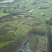
Aerial view of the Antonine Wall at Croy Hill (c. 733 765) and the sites of Croy Hill fort and fortlet, taken from the NW. |
4/3/1997 |
Item Level |
|
|
Photographs and Off-line Digital Images |
D 86197 CS |
RCAHMS Aerial Photography |
Aerial view of the Antonine Wall at Croy Hill (c. 733 765) and the sites of Croy Hill fort and fortlet, taken from the NW. |
4/3/1997 |
Item Level |
|
|
Photographs and Off-line Digital Images |
D 86200 CS |
RCAHMS Aerial Photography |
General aerial view of the Antonine Wall at Croy Hill (c. 730 763) including the sites of Croy Hill fort and fortlet, taken from the NE. |
4/3/1997 |
Item Level |
|
|
Photographs and Off-line Digital Images |
D 86673 CS |
RCAHMS Aerial Photography |
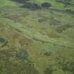
Oblique aerial view of Croy Hill centred on the remains of the Antonine wall and a Roman fort, taken from the NW. |
25/9/1997 |
Item Level |
|
|
Photographs and Off-line Digital Images |
D 86674 CS |
RCAHMS Aerial Photography |
Oblique aerial view of Croy Hill centred on the remains of the Antonine wall and a Roman fort, taken from the WNW. |
25/9/1997 |
Item Level |
|
|
Photographs and Off-line Digital Images |
DB 727 |
RCAHMS Aerial Photography |
Aerial view |
1976 |
Item Level |
|
|
Photographs and Off-line Digital Images |
DB 728 |
RCAHMS Aerial Photography |
Aerial view |
1976 |
Item Level |
|
|
Photographs and Off-line Digital Images |
G 83492 CS |
|
Aerial view of The Antonine Wall at Croy Hill |
|
Item Level |
|
|
Photographs and Off-line Digital Images |
DP 006838 |
|
Digital image of plan of the Roman Fort at Croy Hill showing layout of internal structures. |
|
Item Level |
|
|
Photographs and Off-line Digital Images |
DC 47351/10 |
Records of the Ordnance Survey, Southampton, Hampshire, England |
Ordnance Survey 6-inch to the mile Provisional Edition, revision of 1913-14 with additions in 1946.
Additional annotations by Ordnance Survey for the Antonine Wall map covering the parishes of Kilsyth with Croy Hill. |
c. 1946 |
Item Level |
|
 |
On-line Digital Images |
DP 020991 |
RCAHMS Aerial Photography Digital |
General oblique aerial view centred on the site of the Roman fort and the course of the Antonine Wall with the quarry and canal basin adjacent, taken from the S. |
8/9/2006 |
Item Level |
|
 |
On-line Digital Images |
DP 020992 |
RCAHMS Aerial Photography Digital |
General oblique aerial view centred on the site of the Roman fort and the course of the Antonine Wall, taken from the WNW. |
8/9/2006 |
Item Level |
|


