 |
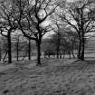
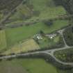
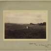
On-line Digital Images |
SC 682363 |
Tom and Sybil Gray |
View of Castlecary Roman Fort
|
15/4/1961 |
Item Level |
|
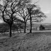 |
On-line Digital Images |
SC 682369 |
Tom and Sybil Gray |
View of Castlecary Roman Fort
|
15/4/1961 |
Item Level |
|
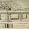 |
On-line Digital Images |
SC 887178 |
|
Plan showing the course of the Roman wall called Grime's Dyke (Antonine Wall). Plate XXXV from 'Military Antiquities of the Romans in Britain'. |
1793 |
Item Level |
|
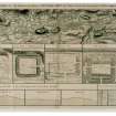 |
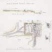
On-line Digital Images |
SC 934405 |
|
Drawing showing the course of the entire Antonine Wall along with plans and sections of the main forts and fortlets along the Wall. Surveyed in 1755.
Titled 'Plan showing the course of the Roman wall called grime's Dyke...together with plans of those stations belonging to the wall'.
|
1793 |
Item Level |
|
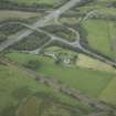 |
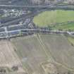
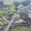
On-line Digital Images |
DP 021000 |
RCAHMS Aerial Photography Digital |
Oblique aerial view centred on the site of the Roman fort and Roman road, taken from the SE. |
8/9/2006 |
Item Level |
|
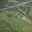 |
On-line Digital Images |
DP 021001 |
RCAHMS Aerial Photography Digital |
Oblique aerial view centred on the site of the Roman fort and Roman road, taken from the ESE. |
8/9/2006 |
Item Level |
|
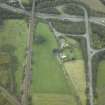 |
On-line Digital Images |
DP 021002 |
RCAHMS Aerial Photography Digital |
Oblique aerial view centred on the site of the Roman fort and Roman road, taken from the E. |
8/9/2006 |
Item Level |
|
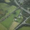 |
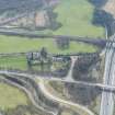
On-line Digital Images |
DP 021003 |
RCAHMS Aerial Photography Digital |
Oblique aerial view centred on the site of the Roman fort and Roman road, taken from the NE. |
8/9/2006 |
Item Level |
|
 |
On-line Digital Images |
DP 021004 |
RCAHMS Aerial Photography Digital |
Oblique aerial view centred on the site of the Roman fort and Roman road, taken from the N. |
8/9/2006 |
Item Level |
|
 |
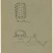
On-line Digital Images |
DP 029433 |
|
Plan and section of the latrine and adjoining foundation of N wall. |
1902 |
Item Level |
|
 |
On-line Digital Images |
DP 249528 |
Historic Environment Scotland |
Oblique aerial view. |
24/3/2017 |
Item Level |
|
 |
On-line Digital Images |
DP 249529 |
Historic Environment Scotland |
Oblique aerial view. |
24/3/2017 |
Item Level |
|
 |
On-line Digital Images |
DP 249530 |
Historic Environment Scotland |
Oblique aerial view. |
24/3/2017 |
Item Level |
|
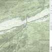 |
On-line Digital Images |
SC 1926555 |
Records of Historic Scotland, Edinburgh, Scotland |
Map 4 of 8 from IV.I 1-8 - Series 1: Maps of the Antonine Wall at a scale of 1:25000 showing the proposed World Heritage Site, known forts and fortlets, camps, other features and the buffer zones. Maps were prepared for the nomination document to propose the extension of the Frontiers of the Roman Empire World Heritage Site through the addition of the Antonine Wall. |
2006 |
Item Level |
|
 |
On-line Digital Images |
SC 1927871 |
Records of Historic Scotland, Edinburgh, Scotland |
Map 4 of 8 from IV.2 1-8 - Series 2: Maps of the Antonine Wall at a scale of 1:25000 showing the proposed World Heritage Site, known forts and fortlets, camps, other features and the buffer zones. Maps were prepared for the nomination document to propose the extension of the Frontiers of the Roman Empire World Heritage Site through the addition of the Antonine Wall. |
2006 |
Item Level |
|
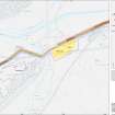 |
On-line Digital Images |
SC 1929344 |
Records of Historic Scotland, Edinburgh, Scotland |
Map 17 of 39 from Series V. Maps of the Antonine Wall and its known features at a scale of 1:5000 showing the scheduled areas and the proposed World Heritage Site. Maps were prepared for the nomination document to propose the extension of the Frontiers of the Roman Empire World Heritage Site through the addition of the Antonine Wall. |
2006 |
Item Level |
|
 |
On-line Digital Images |
SC 1970706 |
Records of Historic Scotland, Edinburgh, Scotland |
Antonine Wall 1:25000 broadsheet map |
2008 |
Item Level |
|
 |
On-line Digital Images |
DP 351737 |
Records of the Society of Antiquaries of Scotland, Edinburgh, Scotland |
Excavation photograph of Castlecary Roman fort showing granary. |
1902 |
Item Level |
|
 |
On-line Digital Images |
DP 351738 |
Records of the Society of Antiquaries of Scotland, Edinburgh, Scotland |
Sketch showing plan and section of granary, Castlecary Roman fort. |
1902 |
Item Level |
|
 |
On-line Digital Images |
DP 351739 |
Records of the Society of Antiquaries of Scotland, Edinburgh, Scotland |
Excavation photograph showing Castlecary Roman fort, looking towards railway near north west end of building. |
1902 |
Item Level |
|
 |
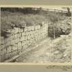
On-line Digital Images |
DP 351740 |
Records of the Society of Antiquaries of Scotland, Edinburgh, Scotland |
Excavation photograph of Castlecary Roman fort showing foundations of north wall. |
1902 |
Item Level |
|
 |
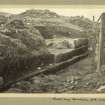
On-line Digital Images |
DP 351741 |
Records of the Society of Antiquaries of Scotland, Edinburgh, Scotland |
General view of the excavation area at Castlecary Roman fort from the west. |
1902 |
Item Level |
|
 |
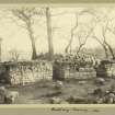
On-line Digital Images |
DP 351742 |
Records of the Society of Antiquaries of Scotland, Edinburgh, Scotland |
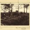
View of the excavations at Castlecary Roman fort during a guided visit by a group of some twenty people, including Thomas Ross. |
10/1902 |
Item Level |
|
 |
On-line Digital Images |
DP 351743 |
Records of the Society of Antiquaries of Scotland, Edinburgh, Scotland |
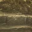
Excavation photograph showing a stone in the wall of Castlecary Roman fort.
|
1903 |
Item Level |
|


