
Keir Knowe Of Drum


Motte (Medieval)
Site Name Keir Knowe Of Drum
Classification Motte (Medieval)
Canmore ID 45375
Site Number NS69NW 9
NGR NS 63652 95362
Datum OSGB36 - NGR
Permalink http://canmore.org.uk/site/45375


- Council Stirling
- Parish Kippen
- Former Region Central
- Former District Stirling
- Former County Stirlingshire
NS69NW 9 6364 9536.
(NS 6364 9536) Keir Knowe of Drum (NAT)
OS 6" map (1958)
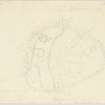
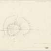
The Keir Knowe of Drum is a motte formed by isolating a promontory with a broad shallow gully. The top, oval on plan, measures 75ft by 70ft and stands between 11 and 40ft above the surrounding ground.
Excavations on the top in 1957 revealed the post-holes, of a square wooden building, probably a tower, defended by stockades and, in one sector by a wall.
No dating evidence was found.
RCAHMS 1963
As described and planned by RCAHMS. The bracken-covered top of this motte, mutilated by the excavations, shows no surveyable features.
Resurveyed at 1/2500.
Visited by OS (WDJ) 26 September 1968
Field Visit (July 1978)
Keir Knowe of Drum NS 636 95.3 NS69NW 9
This motte has been formed from the tip of a promontory cut off from the adjacent land by a broad, shallow gully. The oval summit of the motte measures 23m by 21 m and excavations upon it revealed that it had been occupied by a square wooden building, possibly a tower, defended by three stockades and in one sector by a dry-stone wall.
RCAHMS 1979, visited July 1978
(RCAHMS 1963, pp. 17 6-8, no. 187)

