
Kirkintilloch


Ditch(S) (Roman), Fortlet (Roman)(Possible), Roman Fort (Roman)
Site Name Kirkintilloch
Classification Ditch(S) (Roman), Fortlet (Roman)(Possible), Roman Fort (Roman)
Alternative Name(s) Peel Park
Canmore ID 45204
Site Number NS67SE 15
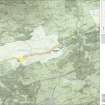
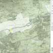
NGR NS 6513 7395
Datum OSGB36 - NGR
Permalink http://canmore.org.uk/site/45204


- Council East Dunbartonshire
- Parish Kirkintilloch (Strathkelvin)
- Former Region Strathclyde
- Former District Strathkelvin
- Former County Dunbartonshire
NS67SE 15 6513 7395.
(NS 6513 7395) Fort (R) (site of)
OS 6" map, (1967)
Discoveries of Roman building stones, a quern stone, a clay jar and Roman coins have long ago been recorded from the neighbourhood of the Peel of Kirkintilloch (NS67SE 8); they pointed to the existence of a fort nearby. In 1914, Sir George Macdonald cut trenches in the park W of the Peel and discovered some hearths, along with tiles and roman pottery. In the years between 1953 and 1961 trenches cut under the auspices of the Hunterian Museum revealed the stone base of the Antonine Wall and the Antonine Ditch, while inside the park there were found to the S of the Antonine Wall remains of streets, gutters and several rows of postholes, belonging to narrow wooden buildings, besides a great quantity of Antonine Pottery. These remains indicate the presence of a fort, or a fort-annexe, and their disturbed condition at the same time suggests that much of the fort has been destroyed by the construction of the medieval peel and its associated structures, and by the laying out and terracing of the Park in more recent times.
A S Robertson 1973; G Macdonald 1918; 1925; 1934.
No surface indications of this fort now exist.
Visited by OS (J L D) 11 January 1957.
During the cutting of foundation trenches for a housing development at 50 Union Street (NS 6509 7390), to the SW of the Peel Park, the lip of a ditch was observed in section, and dark silty soil like ditch-fill was noted at several points, sufficient to suggest a roughly NW-SE alignment. Green-glazed ware was recovered from above the silt. If of Roman rather than medieval date, the ditch could mark the W limit of Kirkintilloch fort or of an annexe.
L J F Keppie 1975.
Excavations in the car park to the S of Peel Park during 1978-9 exposed parts of two ditches which met at right angles and presumably formed the corner of an enclosure. They measured approximately 3.0 m wide, 1.5 m deep, and had a V-shaped profile. They were partly cut into deposits containing Antonine pottery and they contained plentiful deposits of similar pottery as well as Roman leather sandals, a pilum head and worked sandstone blocks.
It is not clear what the ditches enclosed but it is unlikely that they belonged to a fort or annexe; however, perhaps they were part of a civil settlement.
R D Stevenson 1980.
Excavations by SUAT in 1988 on the site of 12 Regent Street (NS 652 739), E of the site of the 1978-9 trenches, uncovered a Roman ditch running parallel to the alignment of that uncovered in 1978-9, but seperated from it by 30m. Trenches were extended 20m towards Union Street but no other Roman features were encountered.
L J F Keppie et al 1995
Excavation (1914)
In 1914, Sir George Macdonald cut trenches in the park W of the Peel and discovered some hearths, along with tiles and roman pottery.
G Macdonald 1918; 1925; 1934
Publication Account (1934)
Discoveries of Roman building stones, a quern stone, a clay jar and Roman coins have long ago been recorded from the neighbourhood of the Peel of Kirkintilloch (NS67SE 8); they pointed to the existence of a fort nearby.
G Macdonald 1918; 1925; 1934
Excavation (1953 - 1961)
In the years between 1953 and 1961 trenches cut under the auspices of the Hunterian Museum revealed the stone base of the Antonine Wall and the Antonine Ditch, while inside the park there were found to the S of the Antonine Wall remains of streets, gutters and several rows of postholes, belonging to narrow wooden buildings, besides a great quantity of Antonine Pottery. These remains indicate the presence of a fort, or a fort-annexe, and their disturbed condition at the same time suggests that much of the fort has been destroyed by the construction of the medieval peel and its associated structures, and by the laying out and terracing of the Park in more recent times.
A S Robertson 1973
Excavation (1953)
NS 6506 7396 The line of the Wall and Ditch was determined by excavation in 1953 and 1958 (Robertson 1966).
Field Visit (11 January 1957)
No surface indications of this fort now exist.
Visited by OS (J L D) 11 January 1957.
Excavation (1958)
NS 6506 7396 The line of the Wall and Ditch was determined by excavation in 1953 and 1958 (Robertson 1966).
Salvage Record (1975)
During the cutting of foundation trenches for a housing development at 50 Union Street (NS 6509 7390), to the SW of the Peel Park, the lip of a ditch was observed in section, and dark silty soil like ditch-fill was noted at several points, sufficient to suggest a roughly NW-SE alignment. Green-glazed ware was recovered from above the silt. If of Roman rather than medieval date, the ditch could mark the W limit of Kirkintilloch fort or of an annexe.
L J F Keppie 1975.
Excavation (1978 - 1979)
Excavations in the car park to the S of Peel Park during 1978-9 exposed parts of two ditches which met at right angles and presumably formed the corner of an enclosure. They measured approximately 3.0 m wide, 1.5 m deep, and had a V-shaped profile. They were partly cut into deposits containing Antonine pottery and they contained plentiful deposits of similar pottery as well as Roman leather sandals, a pilum head and worked sandstone blocks.
It is not clear what the ditches enclosed but it is unlikely that they belonged to a fort or annexe; however, perhaps they were part of a civil settlement.
R D Stevenson 1980.
Field Visit (1982)
Although no structural remains certainly identifiable as belonging to a Roman fort have yet been found at Kirkintilloch, the discovery in the Peel Park of numerous artefacts of 2nd century date, associated with streets, gutters and rows of post-holes, suggests strongly that the Roman station, presumably butting against the S face of the Antonine Wall, lay not far from the medieval peel. The position, on the summit of a ridge with a steep descent to the N, is one which would have recommended itself to the Roman military engineers.
RCAHMS 1982.
Note (1982)
Kirkintilloch, Fort NS 651 739 NS67SE 15
Although no structural remains certainly identifiable as belonging to a Roman fort have yet been found at Kirkintilloch, the discovery in the Peel Park of numerous Roman artefacts of 2nd-century date, associated with streets, gutters and rows of post-holes, suggests strongly that the Roman station, presumably butting against the S face of the Antonine Wall, lay not far from the medieval peel. The position, on the summit of a ridge with a steep descent to the N, is one which would have recommended itself to the Roman military engineers. A stretch of the Wall foundation has been exposed for display in the grounds of the Peel Park.
RCAHMS 1982
(Macdonald 1934, 295,449; Robertson 1964, 180-8; Robertson 1979, 74-6)
Aerial Photography (1982)
Publication Account (1982)
Although no structural remains certainly identifiable as belonging to a Roman fort have yet been found at Kirkintilloch, the discovery in the Peel Park of numerous artefacts of 2nd century date, associated with streets, gutters and rows of post-holes, suggests strongly that the Roman station, presumably butting against the S face of the Antonine Wall, lay not far from the medieval peel. The position, on the summit of a ridge with a steep descent to the N, is one which would have recommended itself to the Roman military engineers.
RCAHMS 1982.
Excavation (1988)
Excavations by SUAT in 1988 on the site of 12 Regent Street (NS 652 739), E of the site of the 1978-9 trenches, uncovered a Roman ditch running parallel to the alignment of that uncovered in 1978-9, but seperated from it by 30m. Trenches were extended 20m towards Union Street but no other Roman features were encountered.
L J F Keppie et al 1995
Resistivity (16 February 2006 - 24 February 2006)
NS 6513 7396 GUARD conducted a geophysical survey on behalf of Historic Scotland in Peel Park, Kirkintilloch, in February 2006 to try to determine the precise character of the Roman remains known to be present there and, more generally, to assess the condition of any other archaeological remains within the scheduled area. Although the survey was unable definitively to determine the character of the Roman remains, it did produce some intriguing anomalies. The survey also recorded the remains of the SW corner of a large earthwork, assumed to be part of the medieval castle of Kirkintilloch, as well as a number of other anomalies which may prove to be of archaeological significance.
Archive to be deposited in the NMRS. Reports lodged with Historic Scotland and the NMRS.
Sponsor: Historic Scotland.
C Rennie, 2006.
Magnetometry (16 February 2006 - 16 February 2006)
NS 6513 7396 GUARD conducted a geophysical survey on behalf of Historic Scotland in Peel Park, Kirkintilloch, in February 2006 to try to determine the precise character of the Roman remains known to be present there and, more generally, to assess the condition of any other archaeological remains within the scheduled area. Although the survey was unable definitively to determine the character of the Roman remains, it did produce some intriguing anomalies. The survey also recorded the remains of the SW corner of a large earthwork, assumed to be part of the medieval castle of Kirkintilloch, as well as a number of other anomalies which may prove to be of archaeological significance.
Archive to be deposited in the NMRS. Reports lodged with Historic Scotland and the NMRS.
Sponsor: Historic Scotland.
C Rennie, 2006.
Publication Account (2008)
A 1:25000 scale map of the Antonine Wall was published by RCAHMS in 2008. The map shows the course of the Antonine Wall on a modern map base, including areas where the Wall is in public ownership or care and can be visited. The data had been collated as part of the project to prepare maps for the World Heritage Site nomination bid.

