
Bothwell, Castle Avenue, Bothwell Castle


Castle (13th Century)
Site Name Bothwell, Castle Avenue, Bothwell Castle
Classification Castle (13th Century)
Alternative Name(s) Valence Castle
Canmore ID 44889
Site Number NS65NE 5
NGR NS 68834 59340
Datum OSGB36 - NGR
Permalink http://canmore.org.uk/site/44889


First 100 images shown. See the Collections panel (below) for a link to all digital images.
- Council South Lanarkshire
- Parish Bothwell (Hamilton)
- Former Region Strathclyde
- Former District Hamilton
- Former County Lanarkshire
NS65NE 5.00 68834 59340
NS65NE 5.01 NS 688 593 Trial Excavation
For (1993) trial excavation (NS 688 593), see NS65NE 5.01
(NS 6880 5933) Bothwell Castle (NR) (Remains of)
OS 6" map (1958)
NMRS REFERENCE
Guardianship monument.
Eric J Hosie - manuscript notes.
Photographic Record (1865 - 1867)
Photograph album with photos compiled and photographed by J McGhie, Hamilton.
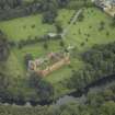
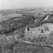
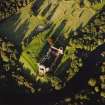
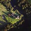
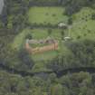
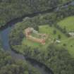
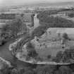
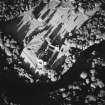
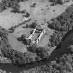
Aerial Photography (April 1968)
Oblique aerial photographs of Bothwell Castle, Lanarkshire, photographed by John Dewar in April 1968.
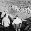
Field Visit (19 August 1976)
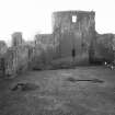
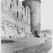
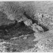
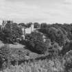
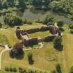
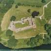
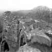
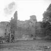
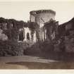
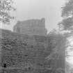
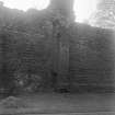
Bothwell Castle was originally built in the late 13th century. It has been demolished and rebuilt after sieges and at various other times during its existence. The DoE have put the remains in a good state of repair, and the castle is fully described, planned and illustrated in the by Simpson (1958).
It was in a similar condition when visited in 1953 by OS (JLD). A collection of material from the castle is in the National Museum of Antiquities of Scotland (NMAS).
W D Simpson 1958
Visited by OS (JLD) 19 August 1976
Excavation (1981)
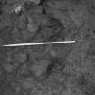
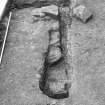
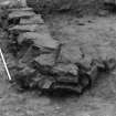
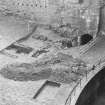
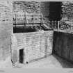
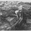
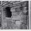
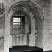
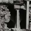
Areas either side of a breach in the north curtain wall were excavated in advance of a small building programme. Work was concentrated mainly to the north of the curtain wall where existed the lower courses of a possible gatehouse, the north and west walls of which were very substantial. The entrance to the gatehouse may have been through its east wall, adjacent to the curtain wall. An intra-mural passage within the north wall of the building could have given access, via a stairway, to the first floor of the gatehouse and possibly to the castle courtyard.
Sponsor: Historic Scotland
J Lewis 1981a.
Publication Account (1985)
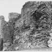
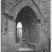
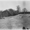
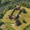
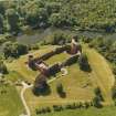
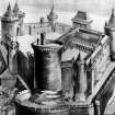
The castle at Bothwell has been described by Douglas Simpson as 'among the foremost secular structures of the Middle Ages in Scotland', and, despite its ruined state, it still remains one of the most imposing of Scotland's earlier medieval castles. Originally planned by Waiter de Moravia (Moray), who acquired the estate in 1242, it was laid out on a grand scale but was apparently only pat1ially completed before the outbreak of the Wars ofIndependence (1296-1357) when it was twice besieged and deliberately dismantled in order to deny it to the English. In 1337, after demolition for a second time, the castle appears to have been abandoned until about 1362. It was then acquired by Archibald 'the Glim', 3rd Earl of Douglas who initiated an extensive programme of rebullding which continued into the early 15th century. In 1669 Bothwell again changed hands, this time passing to the 1st Earl of Forfar who built a new house to the east and partially dismantled the castle to provide stone for the new building.
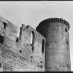
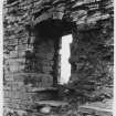
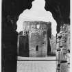
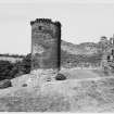
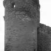
As originally conceived in the mid 13th century, the castle was to comprise a five-sided enceinte with circular angle-towers, a square side-tower, a stoutly defended gatehouse and, dominating the whole structure, a massive round keep or donjon. The more vulnerable east side had the added protection ofIarge earthworks, the north arm of which hooked round the gateway forcing attackers to approach from the south-east, thus exposing themselves to flanking fire from the wall-head. Only the keep, south-east wing wall and angle-tower, however, were completed; the remainder rose little further than foundation level. The keep is a particularly fine example and rivals the best work in England and France.
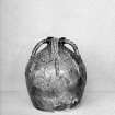
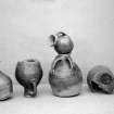
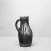
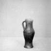
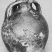
It was not until the late 14th century that the enceinte was completed in stone, probably for Archibald the Grim. The sequence of building, deliberate demolition and rebuilding has made the interpretation of the fbric fraught with difficulty, but recent excavation has helped to solve some of the outstanding problems, as well as bringing to light an important collection of medieval pottery. Many of the vessels were complete and show that, although the forms of the jugs and other pots are of types found in northern England, they were, in fact, produced locally.
Information from ‘Exploring Scotland’s Heritage: The Clyde Estuary and Central Region’, (1985).
Excavation (1991)
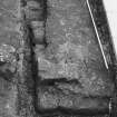
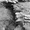
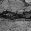
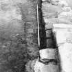
Excavation was carried out early in 1991 in advance of the construction of a new sales point adjacent to the interior of the castle's late 14th/early 15th-century N curtain wall. There was little of archaeological interest other than a 1.50m-wide robber trench, parallel to the curtain but only 2.0m from it, which may have been associated in some way with the entrance into the castle's enclosure.
Sponsor: Historic Scotland
J Lewis 1993
Watching Brief (1993)
Two small scale excavations (in 1987-88 and 1991) within the castle enclosure and a watching brief carried out in 1993 during the topsoil clearance, preceded the installation of a new car park some 100m east of the castle. Trenching to the immediate east of the postern revealed traces of what may have been an extension to the south range; and a possible robber trench, perhaps associated with the gatehouse, was uncovered just inside the modern entrance to the castle.
Sponsor : Historic Scotland
J Lewis 1997
Watching Brief (18 February 1998)
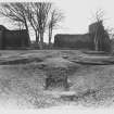
A watching brief was maintained on 18th February 1998 while workmen disturbed an area of the Inner Courtyard around the Custodian’s Office (Fig. 1). The work involved the laying of a flagged pathway along the E, W and S sides of the office, necessitating the lifting of c. 26 m length of thurf, some 1.5 m in width. The necessary depth for the new footpath did not interfere with any buried archaeology.
Sponsor: Historic Scotland
Kirkdale Archaeology 1998
Watching Brief (29 January 1998)
NS 6880 5933 Ground-breaking work was monitored in January 1998. The entirety of the chapel area was to be stripped, along with various other stretches.
To the S of the chapel two roughly shaped sandstone blocks formed a threshold into the SE tower. A 20th-century pathway of fine light grey mortar, leading up to this tower and off to the W, was also found, as were footings for walls. While the vast majority of the work involved little more than turf lifting, the small corner at the E end of the chapel block demonstrated the survival of archaeology.
Sponsor: Historic Scotland
D Murray 1998
Kirkdale Archaeology
Excavation (14 August 2000 - 15 August 2000)
Excavations were carried out at Bothwell Castle in August 2000, during a programme of improvements to the access road. The works included raising sunken parts of the surface paving as well as extending the surfacing to include two additional areas. The excavations were a maximum of 250mm in depth. No archaeological structures were identified, and no finds retrieved.
Sponsor: Historic Scotland
D Stewart 2000
Kirkdale Archaeology
Watching Brief (9 October 2000 - 12 October 2000)
A watching brief was undertaken in October 2000 during minor excavations within Bothwell Castle courtyard. The purpose of the work was to provide five post-holes to take the metal uprights of a protective fence.
The layers of material from these shallow pits appear to be a recent turf landscaping covering a general debris deposit banked up behind the rebuilt revetting wall and used as landscaping to level up this part of the courtyard. No finds were retrieved.
Sponsor: Historic Scotland
G Ewart and D Stewart 2000
Kirkdale Archaeology
Watching Brief (June 2001)
A further watching brief was undertaken in June 2001 while contractors excavated a shallow trench in the SW corner of the castle courtyard.
The purpose of the excavation was to add an extension to an existing set of steps that had been built to allow people access from the inner courtyard down a particularly slippery slope to the postern gate in the S wall of the castle.
The deposits exposed by the excavations were clearly 20th-century landscaping layers laid over early castle masonry. The nature of the masonry sealed by the terram was not established other than the fact that it appeared to be coarse red and pink sandstone. The site has obviously been excavated and backfilled at some recent time. It should be noted that the works did not require any of the sealed masonry to be disturbed.
Sponsor: Historic Scotland
D Stewart and G Ewart 2001
Watching Brief (27 April 2007 - 8 June 2007)
NS 690 594 A watching brief was maintained between 27 April–8 June 2007 during three periods of work at Bothwell Castle to locate and repair a burst water pipe. A small hole for tree planting was also dug. There were no finds or features of archaeological significance.
Archive to be deposited with RCAHMS.
Funder: Historic Scotland.
Information from OASIS ID: kirkdale1-249650 (P Fox) 2007
Field Visit (October 2007 - November 2007)
NS 6883 5934
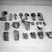
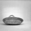
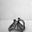
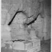
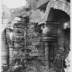
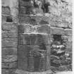
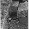
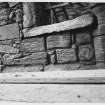
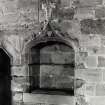
The carved stone collection contains an impressive group of corbels. From the angle of the stone blocks to which the corbels are attached, these must have come from the interior of a tower, the partially demolished donjon tower being the most likely original location. Another group of stones in the collection comes, not from the castle, but from nearby Bothwell House, now demolished. Of early 18th-century date, these are bases and capitals from attached columns. The capitals in particular are extremely intricately carved, with deeply undercut foliage on the outer corners. This inventory was carried out between October and November 2007. This and other inventories of carved stones at Historic Scotland’s properties in care are held by Historic Scotland’s Collections Unit. For further information please contact at hs.collections@scotland.gsi.gov.uk.
Funder: Historic Scotland.
Watching Brief (13 October 2008)
A watching brief was maintained during the location and exposure of a blocked septic tank outside the main visitor's entrance of Bothwell Castle. There were no features or finds of archaeological significance encountered.
Information from OASIS ID: kirkdale1-249658 (P Fox) 2008
Watching Brief (28 June 2009 - 29 June 2009)
NS 6877 5933 A watching brief was maintained 28–29 June 2009 during the examination of the base of a fallen yew tree near the SW corner of Bothwell Castle. The roots contained numerous architectural fragments which were removed and recorded. Some of these sandstone blocks appeared to be parts of architectural features such as windows and doors. It seems most likely that these fragments of masonry are from a demolished or collapsed structure (perhaps the Donjon or the Prison Tower) through which the roots of the tree have grown.
Archive: RCAHMS (intended)
Funder: Historic Scotland
Alan Radley – Kirkdale Archaeology
Information from OASIS ID: kirkdale1-249659 (A Radley) 2009
Watching Brief (24 November 2009)
NS 6891 5940
A watching brief was maintained on 24 November 2009 during the excavation of two holes required for a new sign at the entrance to Bothwell Castle. Nothing of archaeological interest was recorded.
Archive: RCAHMS (intended)
Funder: Historic Scotland
G Ewart 2010
Watching Brief (24 November 2009)
NS 68910 59400 A watching brief was maintained during the excavation of two holes to receive the uprights for a new sign at the entrance to Bothwell Castle. Nothing of archaeological interest was noted.
Information from OASIS ID: kirkdale1-249877 (G Ewart) 2009
Watching Brief (13 October 2009)
NS 6881 5935 A watching brief was maintained on 13 October 2009 during the location and exposure of a blocked septic tank outside the main visitors’ entrance at Bothwell Castle. No archaeological features or finds were encountered.
Archive: RCAHMS (intended)
Funder: Historic Scotland
Paul Fox – Kirkdale Archaeology
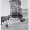
Watching Brief (30 January 2013 - 12 February 2013)
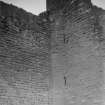
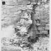
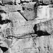
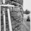
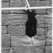
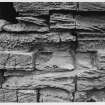
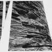
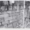
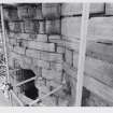
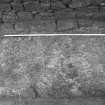
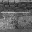
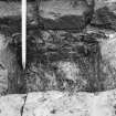
NS 6878 5936 A watching brief was undertaken, 30 January – 12 February 2013, during the removal of rough racking and other recent repairs at the wall head of the N rampart. The repair programme focused on the western half of the 14th-century N rampart, built against a reduced section of residual curtain wall, running up to the circular donjon.
The exposed masonry was examined, recorded and two main phases of construction identified. The surviving upper 1m of the new build consisted of well-shaped rectangular red sandstone blocks, used as facing stones, with more random rubble forming the wall core. The recent rough racking consisted of a jumble of large blocks of red sandstone with copious amounts of cement, creating a random rubble wall core.
The most striking aspect of the N rampart is its sheer mass and stability. This is in part the result of the use of the reinforced centrally placed entrance, the tower at the W end and the short section of masonry built at 90degrees angles to the residual 13th-century N curtain wall. These measures enabled a width to length ratio of c1:10 (2.8m:28m for the main N rampart build). This is comparable to the broadly contemporary ‘Douglas’ work at Tantallon Castle (East Lothian), where a similarly massive and apparently free-standing screening wall is threaded between corner and central towers; a wall c3.6m wide (at intervals) and c35m long. This, and other such basic formulae, appear to be an aspect of a long tradition of wall construction, based on practical experience and a knowledge of the physical properties of the resources available, as much as any by aesthetic/strategic considerations.
Archive: RCAHMS (intended)
Funder: Historic Scotland
Gordon Ewart, Kirkdale Archaeology, 2013
(Source: DES)
Magnetometry (3 April 2015 - 12 April 2015)
NS 68834 59340 A gradiometer survey was undertaken over the outer park area and over all available areas within the Property in Care (PIC) boundary.
Archive: Rose Geophysical Consultants
Funder: Historic Scotland
Susan Ovenden – Rose Geophysical Consultants
(Source: DES, Volume 16)
Resistivity (3 April 2015 - 12 April 2015)
NS 68834 59340 A resistance survey was carried out over all available areas within the PIC boundary and within four sample blocks in the outer park.
Archive: Rose Geophysical Consultants
Funder: Historic Scotland
Susan Ovenden – Rose Geophysical Consultants
(Source: DES, Volume 16)
Project (3 April 2015 - 12 April 2015)
NS 68834 59340 A geophysical survey was undertaken, 3–12 April 2015, as part of wider archaeological investigations of the site. A gradiometer survey was undertaken over the outer park area and over all available areas within the Property in Care (PIC) boundary. A resistance survey was carried out over all available areas within the PIC boundary and within four sample blocks in the outer park. A ground penetrating radar (GPR) survey was undertaken within the inner courtyard and limited areas to the N of the castle.
Although the gradiometer survey was severely affected by magnetic disturbance due to modern paths, fences etc, the data from the PIC area to the N of the castle suggest areas of possible ‘settlement’. The resistance survey detected a wealth of anomalies across the PIC area. The outer park area is dominated by extensive drainage with numerous alignments and phases of drainage having been detected. Within the PIC area, adjacent to the castle, the resistance data suggest the potential for extensive buried remains associated with the outer courtyard of the castle. Although anomalies possibly indicating the extent of the south range within the inner courtyard have been detected, interpretation is cautious due to numerous drains within the area. The GPR survey within the inner courtyard is dominated by responses from drains although anomalies potentially associated with the south range, complementing the resistance survey results, were also been detected. Although the GPR survey to the N of the Castle is dominated by responses from modern paths, several anomalies and areas of increased response have been detected which correlate well with the resistance survey thereby supporting interpretation of the potential for extensive buried archaeological remains in this area.
Archive: Rose Geophysical Consultants
Funder: Historic Scotland
Susan Ovenden – Rose Geophysical Consultants
(Source: DES, Volume 16)
Ground Penetrating Radar (3 April 2015 - 12 April 2015)
NS 68834 59340 A ground penetrating radar (GPR) survey was undertaken within the inner courtyard and limited areas to the N of the castle.
Archive: Rose Geophysical Consultants
Funder: Historic Scotland
Susan Ovenden – Rose Geophysical Consultants
(Source: DES, Volume 16)
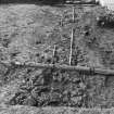
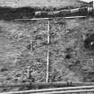
Excavation (10 June 2015 - 2 July 2015)
Under the terms of its PIC contract with Historic Scotland, Kirkdale Archaeology was asked to carry out an archaeological excavation at Bothwell Castle ahead of the replacement of a staircase leading up to the Great Hall, and the installation of an access ramp into the Donjon. The two trenches were excavated by hand, and the work was carried out during June and July, 2015.
G Ewart 2015
Sponsor: Historic Scotland
Kirkdale Archaeology
Excavation (16 June 2015 - 26 June 2015)
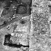
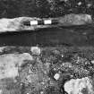
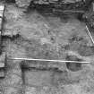
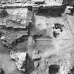
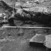
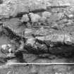
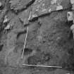
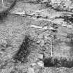
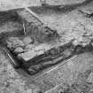
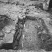
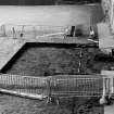
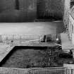
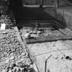
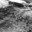
NS 688 593 Following an extensive geophysical survey across the site and immediate environs in early 2015, a series of five trenches (numbered 1, 3, 5, 6, and 7) were excavated in and around Bothwell Castle, 16 June – 26 June, 2015. Trenches 1 and 3 were located within the courtyard/inner ward; Trenches 6 and 7 were excavated within the outer ward; and Trench 5 was excavated over the castle rock, immediately to the SW of the donjon.
In Trenches 1 and 3 there was evidence of re-deposited clays both extending and raising the level of the natural promontory overlooking the Clyde, to create the inner ward in the late-13th century. Evidence was also revealed of the clearance and robbing of inner ward structures during the late-17th century and the truncation of the artificial terrace defining the inner ward. This was then landscaped by further re-deposited clays in order to accommodate garden features (beds and paths) defining an elaborate courtyard garden from the early-18th century – mid-19th century. Finally, the excavation revealed evidence of the stripping out of the courtyard garden, re-turfing and new drainage installation during the mid-to-late 20th century. The work undertaken in Trenches 1 and 3 revealed that successive periods of landscaping have effectively removed almost all evidence of occupation and layout of the medieval courtyard structures originating from the 13th – mid-16th century. Significant evidence survives of the 18th – 19th-century courtyard garden.
In Trench 5, evidence was revealed of the clearance of a level surface at the base of an upper rocky terrace defining the natural promontory overlooking the river. This was subsequently infilled with demolition debris, and levelled over the cleared terrace below. This probably occurred at some time from the 18th century – mid-19th century. During the mid-19th century a path was created over the earlier levelling.
In Trenches 6 and 7 there was evidence of the establishment of the late-13th-century northern defences; these would probably have consisted of stone mural towers with a gatehouse linked by redeposited natural clay and turf, laid over the line of the unfinished stone curtain wall foundations. Excavation further revealed that the 13th-century outer defences were truncated and levelled, then sealed by a second earthwork along the N side of the new rectangular stone castle enclosure (late 15th century – early 16th century). The final sequence of activity identified, involved the levelling and landscaping of all the residual defensive features (late 17th century – early 18th century).
The results of the fieldwork can be described in terms of four historical periods, variously affecting three areas of the castle – the courtyard/inner ward, the northern defences and the S (river) side of the castle.
The first of these, Period I, saw the establishment, at the end of the 13th century, of an enclosure castle of two principal wards. Only the inner ward with its donjon, was completed in stone. The outer ward with its curtain wall was probably completed in timber and earth, using clay and turf as a base between the upstanding stone towers and gateway.
Period II, from the late-14th century – late-15th century, saw the development of a complex fortification surrounding a stone rectangular castle. It was characterised by the clearance of the N curtain wall and levelling of residual defences (N gate and mural towers); the creation of possible artillery earthworks: clay and turf terraces creating a forework along the N face of the stone castle; the widening of the 13th-century (northern) outer ditch; and, the possible backfill of an inner ditch along the line of the N wall of the stone castle.
Period III, from the late-17th century – early-18th century, saw the clearance of the interior of the castle courtyard, and the robbing of the SE tower to create a romantic, rustic compartment defined by the ruined masonry, within an extensive wooded garden/plantation. All N and S courtyard ranges were robbed-out completely and open spaces created; there was landscaping across the courtyard, defined to the W by the residual ditch (W of the donjon), within the courtyard; a possible parterre was laid out with paths and beds across most of the courtyard area; and, the artillery forework to the N was softened and augmented with new terracing to the W, to create an E/W aligned vista, with new plantation to the N.
The final period ascribed, Period IV, of the mid-19th century, saw the creation of an informal landscape with increasingly ornamented/rusticated courtyard gardens and rides. New garden soils were laid over the parterre; informal planting was carried out around the E, W and S sides of the castle; and, paths and rides were established around the castle and a substantial terrace created above the river, with exotic specimen planting.
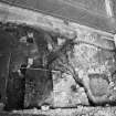
Further minor excavations were undertaken at Bothwell Castle, 29 June – 2 July 2015, ahead of the replacement of a staircase leading up to the Great Hall (NS 6882 5934), and the installation of an access ramp into the donjon (NS 6878 5935). Most deposits seen appeared to be associated with relatively recently-imported levelling material or interventions resulting from modern structures. There were some areas where earlier deposits were seen, undisturbed by modern activity, but there were no finds or features of archaeological significance during this work.
Archive: National Record of the Historic Environment (NRHE) intended
Funder: Historic Scotland
Gordon Ewart and Paul Fox - Kirkdale Archaeology
(Source: DES, Volume 16)
Watching Brief (December 2018 - March 2019)
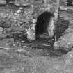
NS 68777 59354 A watching brief was carried out during works to replace the access bridge structure at the entrance to the donjon tower, from December 2018 to March 2019. Monitored work included the uplift and ground reduction of the existing slabbed pathway, the excavation of a foundation trench for the new bridge structure, the removal of a modern lime concrete screed at the donjon entrance, and the removal of rough racking along the top of the chemise wall to allow the removal of a modern metal balustrade. No archaeological remains were uncovered in the excavation.
Archive: NRHE (intended)
Funder: Historic Environment Scotland
Bethan Gray ̶ CFA Archaeology Ltd
(Source: DES Vol 20)
External Reference
EXTERNAL REFERENCE
National Library - Nattes Drawings. Vol 1. No 49 1 drawing
Vol 1. No 57 1 drawing
Vol 1 Nos. 58-60 3 drawings
National Library - 'Sketches of Scottish Scenery' No 9 - 1 sketch

