
Inverpolly


Dun (Period Unassigned)
Site Name Inverpolly
Classification Dun (Period Unassigned)
Alternative Name(s) Meall An Iaruinn
Canmore ID 4481
Site Number NC01NE 1
NGR NC 0661 1551
Datum OSGB36 - NGR
Permalink http://canmore.org.uk/site/4481


- Council Highland
- Parish Lochbroom
- Former Region Highland
- Former District Ross And Cromarty
- Former County Ross And Cromarty
NC01NE 1 0661 1551
(Centred NC 0660 1550) Meall an Iaruinn (NAT)
OS 6" map, Sutherland, 1 st ed., (1881)
'Vitrified fort. Name means "Iron Hillock" '.
OS 6" map annotated by I Crawford, September 1961.
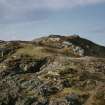
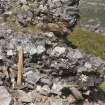
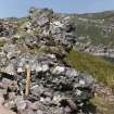
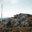
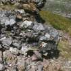
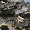
At the N end of a rocky promontory, on the summit of a knoll, is a near circular enclosure, average diameter 18.0m, bounded by the remains of a vitrified stone wall, maximum height 1.5m. Access to the interior, which is in the form of a hollow, was probably from the S where the slopes of the knoll are less steep. To the SW of the enclosure is an outer annexe, with an entrance to the E.
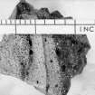
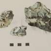
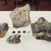
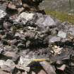
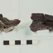
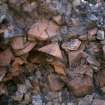
In both enclosure and annexe the vitrified wall takes the form of a mass of small shaly stones fused together by great heat. Except for the E side of the main enclosure where there are two distinct 'skins', the vitrification does not seem to have been localised. There are various hollows in the wall but nothing that could be identified as timber bracing.
Across the neck of the promontory is a low stony bank, possibly part of the defences. It shows no evidence of vitrification.
Visited by OS (E G), 31 May 1962.
A small vitrified fort occupying a promontory, which is almost insulated at high tide, and which is best approached by boat. The main enclosure wall is heavily and generally vitrified. Specimens of the vitrified material are in the National Museum of Antiquities of Scotland (NMAS), donated by Mrs E Mason, Edinburgh.
F W Feachem 1963; Proc Soc Antiq Scot 1964.
A vitrified dun, with annexe and outwork, at NC 0661 1551. The circular dun occupies the summit of a knoll, and measures c. 12.5m in diameter within a heavily vitrified wall which must have been at least 5.0m thick. A slight dip in the bank of debris in the SE is suggestive of an entrance but is probably misleading as the entrance would be expected more to the S.
Immediately outside the dun at a lower level are the remains of another heavily vitrified structure. Insufficient is visible, however, to establish its true relationship with the dun, though it seemslikely that it is a contemporary annexe rather than an earlier work. There is no defnite sign of an entrance.
Blocking the approach from the S is an outwork comprising a wall of small stones reduced almost to its foundation. At one point is a small mass of vitrifaction suggesting that this too was timber-laced and at least partly vitrified. An entrance is denoted by a gap in the rubble.
Revised at 1:10,000.
Visited by OS (A A), 7 August 1974.
Note (7 February 2015 - 25 November 2016)
A heavily vitrified dun occupies the summit of a promontory which is also cut off on the landward side by the remains of a wall drawn obliquely across its relatively narrow neck. The dun measures about 12.5m in diameter within a heavily vitrified wall in the order of 5m in thickness, and there is another heavily vitrified wall forming a small annexe on a lower terrace on its SW flank. The outer wall barring access to the promontory from the S is reduced to little more than a band of rubble spanning the neck between two clefts in its rocky flanks and extending a little way along its SW margin; a single small mass of vitrifaction has been observed amongst the rubble, and there is a gap for an entrance towards the W side. To its rear the promontory is roughly triangular on plan, measuring a 100m from N to S along its E flank by a maximum of 60m transversely (0.39ha). The relationship between the dun and the wall across the promontory is unknown.
Information from An Atlas of Hillforts of Great Britain and Ireland – 25 November 2016. Atlas of Hillforts SC2798

