
Castlehill


Fortlet (Roman)(Possible), Roman Fort (Roman)
Site Name Castlehill
Classification Fortlet (Roman)(Possible), Roman Fort (Roman)
Alternative Name(s) Antonine Wall, Castlehill, Bearsden
Canmore ID 44510
Site Number NS57SW 1
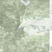
NGR NS 52482 72614
Datum OSGB36 - NGR
Permalink http://canmore.org.uk/site/44510


- Council East Dunbartonshire
- Parish New Kilpatrick (Bearsden And Milngavie)
- Former Region Strathclyde
- Former District Bearsden And Milngavie
- Former County Dunbartonshire
NS57SW 1.00 52482 72614
NS57SW 1.01 NS 523 729 Roman Pick
(NS 5250 7270) Fort (R) (site of)
OS 1:10,000 map, (1973)
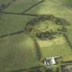
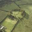
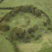
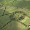
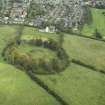
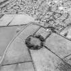
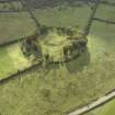
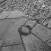
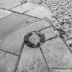
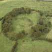
The existence of a Roman fort on Castlehill was indicated by the discovery of a column-capital in 1847 and of an altar (NS57SW 9) in 1826. More recently, Dr St Joseph has observed from the air the south ditches, the south-east angle, and a short length of the east side of the fort. There is a gate about the centre of the south side. If the fort was attached to the south of the Wall, its size would be some 350' E-W by 425'. In 1970-1, Antonine pottery was found in the roots of fallen trees on the summit of Castlehill.
A S Robertson 1973; J K S St Joseph 1951; G Macdonald 1934.
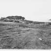
No traces of a fort are visible at Castlehill, the area consisting of a tree plantation some 1.0m in height. Position of fort plotted from St Joseph air photograph.
Visited by OS (D S) 14 January 1957.
NS 524 726 Further pottery fragments were discovered beside tree roots in 1972 and 1974.
M C Jarvis 1974.
Dr Keppie suggests that there may be a fortlet on the very summit of Castle Hill, outwith the NW corner of the established fort area but still attached to the S side of the Antonine Wall. It is argued that from the dimensions given by the early antiquaries, with the exception of Maitland, they descibe this fortlet rather than the much larger fort, and that a raised area noted and depicted by Roy may still be visible as a turfed 'plateau' some 30m square.
L J F Keppie 1980.
The only ground trace of the fort may be a vague linear depression in the southern half of the plantation enclosure, which probably corresponds to the outer ditch lines of the W side of the fort.The E & S defences fall within featureless arable fields. At NS 5241 5271 is an apparently artificial swelling, very roughly square and of the dimensions given, but having no identifiable form or positive indications of antiquity.
Revised at 1:1250.
Visited by OS (J R L) 5 March 1982 and (M J F) 7 July 1980.
Artefact Recovery (1826)
The existence of a Roman fort on Castlehill was indicated by the discovery of an altar (NS57SW 9) in 1826.
G Macdonald 1934
Artefact Recovery (1847)
The existence of a Roman fort on Castlehill was further indicated by the discovery of a column-capital in 1847.
G Macdonald 1934
Aerial Photography (14 July 1947)
Aerial Photography (20 July 1947)
Aerial Photography (1951)
Dr St Joseph has observed from the air the south ditches, the south-east angle, and a short length of the east side of the fort. There is a gate about the centre of the south side. If the fort was attached to the south of the Wall, its size would be some 350' E-W by 425'.
J K S St Joseph 1951
Field Visit (14 January 1957)
No traces of a fort are visible at Castlehill, the area consisting of a tree plantation some 1.0m in height. Position of fort plotted from St Joseph air photograph.
Visited by OS (D S) 14 January 1957.
Artefact Recovery (1970 - 1971)
In 1970-1, Antonine pottery was found in the roots of fallen trees on the summit of Castlehill.
A S Robertson 1973
Artefact Recovery (1972 - 1974)
NS 524 726 Further pottery fragments were discovered beside tree roots in 1972 and 1974.
M C Jarvis 1974.
Field Visit (August 1977)
Castehill NS 525 727 NS57SW
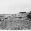
This Antonine Wall fort occupies the summit of Castlehill (120m OD). Crop-markings on air photographs have revealed double ditches delineating most of the S side, the SE angle and a short length of the E side of the fort which measures 129m by 107 m (1.4ha).
RCAHMS 1978, visited August 1977
(Macdonald 1934, 326-8; St Joseph 1951, 61-2; Robertson 1973, 85)
Field Visit (7 July 1980)
The only ground trace of the fort may be a vague linear depression in the southern half of the plantation enclosure, which probably corresponds to the outer ditch lines of the W side of the fort. The E & S defences fall within featureless arable fields. At NS 5241 5271 is an apparently artificial swelling, very roughly square and of the dimensions given, but having no identifiable form or positive indications of antiquity.
Revised at 1:1250.
Visited by OS (M J F) 7 July 1980.
Publication Account (1980)
Dr Keppie suggests that there may be a fortlet on the very summit of Castle Hill, outwith the NW corner of the established fort area but still attached to the S side of the Antonine Wall. It is argued that from the dimensions given by the early antiquaries, with the exception of Maitland, they descibe this fortlet rather than the much larger fort, and that a raised area noted and depicted by Roy may still be visible as a turfed 'plateau' some 30m square.
L J F Keppie 1980.
Field Visit (5 March 1982)
The only ground trace of the fort may be a vague linear depression in the southern half of the plantation enclosure, which probably corresponds to the outer ditch lines of the W side of the fort. The E & S defences fall within featureless arable fields. At NS 5241 5271 is an apparently artificial swelling, very roughly square and of the dimensions given, but having no identifiable form or positive indications of antiquity.
Revised at 1:1250.
Visited by OS (J R L) 5 March 1982.
Geophysical Survey (March 2008)
NS 5250 7270 Topographic, magnetic and resistivity surveys of much of the summit and eastern slope of the hill were carried out during March 2008. The magnetic survey detected the fort’s E and W gates, parts of the N, W and E defences, as well as traces of structures within the fort, but failed to find evidence for a fortlet in the NW corner of the fort. Among the features identified by the resistivity survey was an enclosure lying within the western part of the fort, possible entrances to that enclosure, and structures on the E side of the fort.
Richard Jones, Jeremy Huggett and Alan Leslie (Archaeology Department, Glasgow University), 2008
Publication Account (2008)
A 1:25000 scale map of the Antonine Wall was published by RCAHMS in 2008. The map shows the course of the Antonine Wall on a modern map base, including areas where the Wall is in public ownership or care and can be visited. The data had been collated as part of the project to prepare maps for the World Heritage Site nomination bid.

