
Glasgow, Stobcross, Queen's Dock


Dock (Period Unassigned)
Site Name Glasgow, Stobcross, Queen's Dock
Classification Dock (Period Unassigned)
Alternative Name(s) Stobcross Dock; River Clyde; Inner Harbour; Pointhouse Road
Canmore ID 44157
Site Number NS56NE 88
NGR NS 56790 65430
NGR Description Centred NS 56790 65430
Datum OSGB36 - NGR
Permalink http://canmore.org.uk/site/44157


- Council Glasgow, City Of
- Parish Glasgow (City Of Glasgow)
- Former Region Strathclyde
- Former District City Of Glasgow
- Former County Lanarkshire
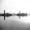
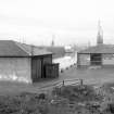
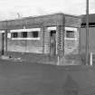
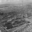
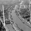
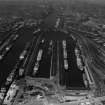
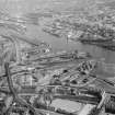
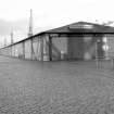
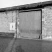
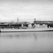
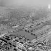
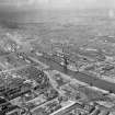
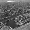
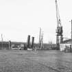
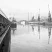
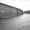
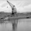
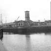
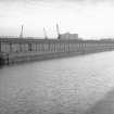
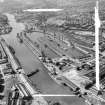
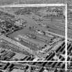
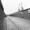
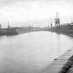
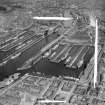
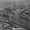
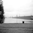
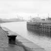
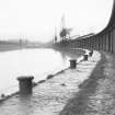
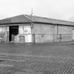
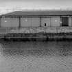
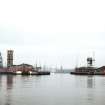
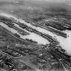
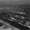
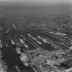
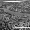
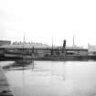
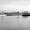
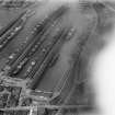
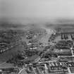
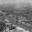
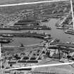
Queen's Dock, originally known as Stobcross Dock, was built from 1872 and opened by Queen Victoria in 1877. It provided two basins, a hydraulic swing bridge, coaling cranes and brick transit sheds. A decline in river traffic from the 1950s resulted in closure of the dock in 1969.
Information from RCAHMS (SC) 17 August 2007
Hume, J 1974
Queen's Dock, 1882, James Deas
The opening of the Queen's Dock and the railway spelt the end of Stobcross House and Finnieston. Cut and built in Giffnock stone, the Dock transformed the area into a city service centre, legacies of which are still evident. It was filled for the Scottish Exhibition Centre (see below). Only the Finnieston Crane, 1932, by Cowans Sheldon, now recalls the mercantile bustle. The craine could load railway engines and tanks on to cargo ships, which is said to be one reason for its survival. Otherwise the engineering works have gone.
Taken from "Greater Glasgow: An Illustrated Architectural Guide", by Sam Small, 2008. Published by the Rutland Press http://www.rias.org.uk

NS56NE 88.00 centred 56790 65430
Location also cited as NS 5633 6557 to NS 5727 6536.
NS56NE 88.01 NS 56360 65575 Hydraulic Swing Bridge (at dock entrance)
NS56NE 88.02 NS 56355 65618 Hydraulic Power Station (at dock entrance)
NS56NE 88.03 NS 57100 65400 North Basin
NS56NE 88.04 NS 57050 65340 Centre Pier
NS56NE 88.05 NS 56880 65340 South Basin
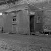
NS56NE 88.06 NS c. 566 653 Lascars' Lavatory Block (Stobcross Quay)
For flint arrowhead found during dock construction, see NS56NE 15.
For (associated and adjacent) Stobcross Quay (NS 5674 6532) and Finnieston Cantilever Crane (NS 57103 65151), see NS56NE 123.00 and NS56NE 123.01 respectively.
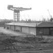
For subsequent use of the site (Scottish Exhibition and Conference Centre), see NS56NE 144.00.
Queen's Dock [NAT] (at NS 5668 6555)
OS 1:1250 map, 1969.
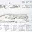
Queen's Dock, originally known as Stobcross Dock, planned in 1846; construction was re-authorised in 1870, and started in 1872. The dock was opened in August 1877 when the Anchor liner, Victoria, entered the tidal basin, though the last copestone was not laid until 20 March 1880. The dock has two basins, an area of 33.5 acres [13.6ha], and has single-storey brick warehouses lining the quays.
At the entrance, there was, until the 1950's, a hydraulic swing bridge (NS56NE 88.01) by Sir William Arrol, and a hydraulic pumping station (NS56NE 88.02) for both bridge and cranes.
The dock closed on 31 December 1969.
J R Hume 1974.
(Illustrations include plans of dock as proposed and as completed. photographs illustrating work in progress and construction of quay walls, and aerial view in 1931).
J Riddell 2000.
This tidal (unlocked) dock formerly occupied a projection from the N bank of the River Clyde, within the area of the Lower Harbour. The dock has been infilled and its area redeveloped.
Information from RCAHMS (RJCM), 15 February 2006.
Construction (1872 - 1880)
Field Visit (28 January 1967)
Field Visit (1970)
Reference (1974)
Queen's Dock, originally known as Stobcross Dock, planned in 1846; construction was re-authorised in 1870, and started in 1872. The dock was opened in August 1877 when the Anchor liner, Victoria, entered the tidal basin, though the last copestone was not laid until 20 March 1880. The dock has two basins, an area of 33.5 acres [13.6ha], and has single-storey brick warehouses lining the quays.
At the entrance, there was, until the 1950's, a hydraulic swing bridge (NS56NE 88.01) by Sir William Arrol, and a hydraulic pumping station (NS56NE 88.02) for both bridge and cranes.
The dock closed on 31 December 1969.
J R Hume 1974.
Project (2007)
This project was undertaken to input site information listed in 'Civil engineering heritage: Scotland - Lowlands and Borders' by R Paxton and J Shipway, 2007.
Publication Account (2007)
David Logan and later engineers continued the practice of dredging and by 1871, under the direction of Clyde Navigation Engineer James Deas, a minimum depth of 22 ft at high water was available between Greenock and the Broomielaw quays, a distance of some 22 miles.
The 61-acre Queen’s Dock was built from 1872– 80 with basins 1866 ft, 1647 ft and 1000 ft long. Built under the direction of Deas and exemplify the heyday of Glasgow as a mercantile port and, in terms of population, Britain’s second largest city.
R Paxton and J Shipway
Reproduced from 'Civil Engineering heritage: Scotland - Lowlands and Borders' with kind permission of Thomas Telford Publishers.
Desk Based Assessment (1 July 2008 - 4 July 2008)
An archaeological baseline study for a scoping exercise was conducted as part of a planning application for a proposed developement of the area. Prior to 1850 the site comprised part of the Stobcross estate and was primarily farmland. With the building of St Vincent Crescent, by the Glasgow architect Alexander Kirkland, just to the north of the site the area was developed for a boating lake and formal gardens. By the 1930's the artificial lake had been filled in and the site utilised for tennis courts, bowling greens and light industrial units. An geotechnical survey conducted in during 2006 indicated that made ground deposits, up to 3m in depth, existed across the proposed developement area.
Information from Oasis (headland1-51498) 20 November 2012

