
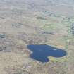
Lewis, Lower Bayble, Loch An Duin


Causeway (Prehistoric), Dun (Prehistoric)
Site Name Lewis, Lower Bayble, Loch An Duin
Classification Causeway (Prehistoric), Dun (Prehistoric)
Canmore ID 4397
Site Number NB53SW 6
NGR NB 51682 30437
Datum OSGB36 - NGR
Permalink http://canmore.org.uk/site/4397


- Council Western Isles
- Parish Stornoway
- Former Region Western Isles Islands Area
- Former District Western Isles
- Former County Ross And Cromarty
NB53SW 6 51682 30437
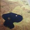
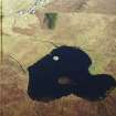
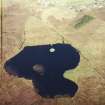
(NB 516 305) Dun (NR) (Site of): Stepping Stones (NAT)
OS 6" map, Ross-shire, 2nd ed., (1899)
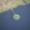
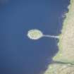
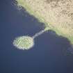
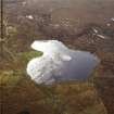
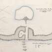
The remains of a dun on an islet, external diameter approx. 50ft, joined to the mainland by a causeway which was 9ft broad in 1914. Mainly a mass of tumbled stones 4 to 5 feet deep, but the outer face of the wall, which was built round the water's edge, was traceable in parts as a single course of stones,and one short section stood 3ft high.
RCAHMS 1928.
As described in RCAHMS. The outer face of the wall is visible all round the SE half of the circumference, with tumble extending 2.m. beyond it to the waters' edge. The internal face is nowhere traceable and the thickness of the wall cannot be estimated, nor can the entrance be seen.
Visited by OS (A L F R) assistant archaeology officer 22 April 1964.
Field Visit (23 June 1914)
Dun, Loch an Dun, Lower Bayble, Eye Peninsula.
Some 30 yards from the northern side of Loch an Dun, about ¼ mile south-west of Lower Bayble, is an islet covered with amass of tumbled stones to a depth of from 4 to 5 feet, the remains of a dun. The outer face of the wall which has been built round the water's edge is traceable in parts as a single course of stones, but one short section is still in position to a height of 3 feet. The dun has had an exterior diameter of some 50 feet, and is connected with the shore by a causeway now 9 feet broad.
RCAHMS 1928, 23 June 1914
OS map: Lewis xxviii.

