
Busby, Upper Mill


Cotton Mill (Period Unassigned), Dam (Period Unassigned), Lade (Period Unassigned)
Site Name Busby, Upper Mill
Classification Cotton Mill (Period Unassigned), Dam (Period Unassigned), Lade (Period Unassigned)
Alternative Name(s) Upper Dam
Canmore ID 43842
Site Number NS55NE 48
NGR NS 5795 5671
Datum OSGB36 - NGR
Permalink http://canmore.org.uk/site/43842
Ordnance Survey licence number AC0000807262. All rights reserved.
Canmore Disclaimer.
© Copyright and database right 2024.
- Correction
- Favourite

DP 071369
View of Upper Weir and Busby Bridge (in background).
General Collection
© Nisbet, Stuart M

DP 071370
View of Upper Weir from the mill side.
General Collection
© Nisbet, Stuart M


DP 071475
View of former sluice fixing on upper pond wall.
General Collection
© Nisbet, Stuart M

DP 071477
View of upper pond wall above lade outlet.
General Collection
© Nisbet, Stuart M


DP 071503
View of upper right wall of wheel pit.
General Collection
© Nisbet, Stuart M

DP 071504
View of upper right wall of wheel pit.
General Collection
© Nisbet, Stuart M

DP 071508
View of upper right wall of wheel pit.
General Collection
© Nisbet, Stuart M

DP 071510
View of lower right wall of wheel pit.
General Collection
© Nisbet, Stuart M


DP 071519
Detail view of left wall of wheel pit.
General Collection
© Nisbet, Stuart M


DP 071545
Detail view of left wall of wheel pit.
General Collection
© Nisbet, Stuart M

DP 071368
View of Upper Weir from Busby Glen park showing steps in front of sluice and curved modern concrete dam blocking entrance to upper pond behind sluice.
General Collection
© Nisbet, Stuart M

DP 071383
View of terracing supporting cliff above the Upper Mill.
General Collection
© Nisbet, Stuart M


DP 071439
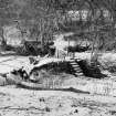
View of Upper Mill foundations at waterfall.
General Collection
© Nisbet, Stuart M


DP 071451
View of mill corner and terracing above wheel pit.
General Collection
© Nisbet, Stuart M

DP 071515
View of lower right wall of wheel pit.
General Collection
© Nisbet, Stuart M

DP 071517
Detail view of left wall of wheel pit.
General Collection
© Nisbet, Stuart M

DP 071526
View of water wheel scoring on left wall of wheel pit.
General Collection
© Nisbet, Stuart M

DP 071528
View of lower left wall of wheel pit.
General Collection
© Nisbet, Stuart M

DP 071537
View downstream from wheel pit into tunnel.
General Collection
© Nisbet, Stuart M


DP 071478
View of upper pond wall above lade outlet.
General Collection
© Nisbet, Stuart M


DP 071487
View of 'steps' on downstream side of upper weir sluice.
General Collection
© Nisbet, Stuart M

DP 071488
View of masonry wall of upper weir sluice.
General Collection
© Nisbet, Stuart M


DP 071512
Detail view of right wall of wheel pit.
General Collection
© Nisbet, Stuart M

DP 071518
Detail view of left wall of wheel pit.
General Collection
© Nisbet, Stuart M

DP 071523
View of upper left wall of wheel pit.
General Collection
© Nisbet, Stuart M


DP 071384
View from wheel pit to arch of upper tunnel.
General Collection
© Nisbet, Stuart M


DP 071461
View of waterfall and upper mill foundation.
General Collection
© Nisbet, Stuart M


DP 071509
View of lower right wall of wheel pit.
General Collection
© Nisbet, Stuart M

DP 071520
Detail view of left wall of wheel pit.
General Collection
© Nisbet, Stuart M

DP 071524
View of upper left wall of wheel pit.
General Collection
© Nisbet, Stuart M

DP 071527
View of lower left wall of wheel pit.
General Collection
© Nisbet, Stuart M

DP 071529
View of lower left wall of wheel pit.
General Collection
© Nisbet, Stuart M


DP 071538
View downstream from wheel pit into tunnel.
General Collection
© Nisbet, Stuart M


DP 071393
View of brick archaed area in Upper Tunnel.
General Collection
© Nisbet, Stuart M


DP 071530
View of lower left wall of wheel pit.
General Collection
© Nisbet, Stuart M

DP 071374
View of brick arched entrance to upper pond.
General Collection
© Nisbet, Stuart M


DP 071460
View of upper mill foundations at waterfall.
General Collection
© Nisbet, Stuart M


DP 071521
View of left wall and downstream wall of wheel pit.
General Collection
© Nisbet, Stuart M


SC 2426967
Busby, Upper Mill, NS55NE 48, Ordnance Survey index card, Recto
Records of the Ordnance Survey, Southampton, Hampshire, England
1958
© Crown Copyright: HES (Ordnance Survey Archaeology Division Collection)


DP 071516
View of upper right wall of wheel pit.
General Collection
© Nisbet, Stuart M

DP 071525
View of water wheel scoring on left wall of wheel pit.
General Collection
© Nisbet, Stuart M


DP 071392
View of brick arched area in Upper Tunnel.
General Collection
© Nisbet, Stuart M


DP 071476
View of upper pond wall above lade outlet.
General Collection
© Nisbet, Stuart M


First 100 images shown. See the Collections panel (below) for a link to all digital images.
- Council East Renfrewshire
- Parish Mearns
- Former Region Strathclyde
- Former District Eastwood
- Former County Renfrewshire
NS55NE 48 5795 5671
Depicted on OS 6" map, Renfrewshire, 1st ed., (1863), sheet xvii

