
Glasgow, Flenders Road, Greenbank House


Country House (18th Century)
Site Name Glasgow, Flenders Road, Greenbank House
Classification Country House (18th Century)
Alternative Name(s) Clarkston; Mearns Road; Whitecraigs
Canmore ID 43815
Site Number NS55NE 23
NGR NS 56121 56644
Datum OSGB36 - NGR
Permalink http://canmore.org.uk/site/43815


- Council East Renfrewshire
- Parish Mearns
- Former Region Strathclyde
- Former District Eastwood
- Former County Renfrewshire
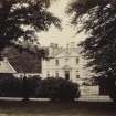
Greenbank House, High Flenders Road, 1764, possibly Allan Dreghorn
Dreghorn died in 1764, and the building was completed the following year for Robert Allason, grandson of the local farmer, who started as a baker's apprentice in Glasgow's Gorbals, then went on to become one of the elite Virginia merchants. Greenbank, at a height of about 90m (300ft), sits on a rise above Mearns Road, looking north over the Clyde Valley. With 16 formal rooms, plus large and convenient offices, Greenbank is one of the few mansions of that period around Glasgow surviving intact and is unique in its full symmetrical frontage, with two projecting wings joined by curved screen walls in a quadrant. Allason was also a pioneer in building a formal walled garden planted with fruit trees and vegetables rather than flowers and shrubs. National Trust for Scotland, gardens open to the public, guide book.
Taken from "Greater Glasgow: An Illustrated Architectural Guide", by Sam Small, 2008. Published by the Rutland Press http://www.rias.org.uk

NS55NE 23.00 56121 56644.
(NS 56121 56644) Greenbank (NAT)
OS 1:10,000 map, (1974)
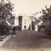
Greenbank House, a Georgian mansion, was built about 1765. It is two storeys high and has a basement. Two projecting wings are connected to the main house by curved screen walls, forming a forecourt.
HBD No. 2
Lintel at Greenbank dated 1763.
Information contained in letter from T C Welsh to OS, 7 September 1975.
NMRS REFERENCE:
Built 1769.
EXTERNAL REFERENCE
Mitchell Library. J. Maclehose's Country Houses - 1 photograph
NS55NE 23.01 Centred on 56069 56580 Garden, sundial.
Photographic Record (1885)
Photographs in album titled 'Views in Busby, East-Kilbride, Carmunnock, Mearns, Eaglesham, and their vicinity 1885'
Geophysical Survey (4 June 2013)
NS 5610 5663 A ground resistance survey was carried out on 4 June 2013 in the walled garden at Greenbank House. An area of 52 x 40m was examined to look for evidence of the layout of the earlier formal garden. The survey recorded probable paths or hard standings as areas of high resistance. Several areas of low resistance were also recorded, an almost perfect square of c7 x 7m is possibly the site of a flower bed or pond.
Archive: The National Trust for Scotland, RCAHMS and WoSAS (intended)
Funder: The National Trust for Scotland and EAFS
Don Matthews, Edinburgh Archaeological Field Society, 2013
(Source: DES)

