
Cumnock, The Square, Market Cross


Market Cross (18th Century), Sundial (18th Century)
Site Name Cumnock, The Square, Market Cross
Classification Market Cross (18th Century), Sundial (18th Century)
Alternative Name(s) Townhead Street; Crossrigs; Mercat Cross
Canmore ID 43605
Site Number NS52SE 9
NGR NS 56783 20132
Datum OSGB36 - NGR
Permalink http://canmore.org.uk/site/43605


- Council East Ayrshire
- Parish Old Cumnock
- Former Region Strathclyde
- Former District Cumnock And Doon Valley
- Former County Ayrshire
NS52SE 9 56783 20132
(NS 5679 2013) Monument (NAT)
OS 25" map (1969)
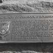
Cumnock market cross stands in the main square of Old Cumnock. On five steps, the shaft is square in section with splayed angles; it supports a square stone sundial and ball finial. Two sides of the sundial are sculptured with the arms of the Crightons and dates '1703; repaired 1778'. In 1900, the whole was surmounted by a gas lamp (J Small 1900). This cannot be the original cross as the right to erect a market cross was granted to Cummock by James IV in 1509. Also, it does not occupy its original position. No-one knows when it was placed there, but it could not have been before the churchyard was removed (being replaced by The Square). A chart in the possession of the Marquis of Bute represents the cross as standing at the NE corner of The Square, just where the Barrhill Road touches it (NS 5671 2018). Yet this does not seem to be the original site. A reliable tradition states that it stood near the top of the Townhead (called The Crossrigs by old inhabitants), where the street is narrowest and slopes down towards the old ironstone pit. A causeway of waterworn stones has been made for some reason at the point. A stone, larger that the others, and about 9 ins square, right in the middle of the street marks the spot where the cross is said to have originally stood.
J Warrick 1899
The cross is generally as described. The steps are modern. The name Townhead or Crossrigs appears to be no longer known in reference to a specific area, but the description ties with the western end of Townhead Street (area NS 5687 2013), the road surface of which is now uniformly asphalted.
Visited by OS (JRL) 23 October 1981
Non-Guardianship Sites Plan Collection, DC23378, 1970.
Publication Account (1995)
Standing to the south of the parish church is the old market cross figure 14.C, the only Scheduled Ancient Monument in Cumnock. This is not its original position (see pp 51-2 and figures 14.N & 15.K/L). Its first site may have been in Townhead Street, but in the eighteenth century it was transferred to, or first erected at the north-east corner of the Square, from where it was moved to ease access in that area. Topped with a sundial, it bears the arms and motto of the earls of Dumfries and the dates '1703 repaired 1778' figure 4.
Information from ‘Historic Cumnock: The Archaeological Implications of Development’ (1995).

