
Following the launch of trove.scot in February 2025 we are now planning the retiral of some of our webservices. Canmore will be switched off on 24th June 2025. Information about the closure can be found on the HES website: Retiral of HES web services | Historic Environment Scotland
Lewis, Galson


Long Cist(S) (Early Medieval), Midden (Iron Age) - (Medieval), Settlement (Iron Age) - (Medieval), Souterrain (Prehistoric)(Possible), Pin (Bone)(Period Unknown)
Site Name Lewis, Galson
Classification Long Cist(S) (Early Medieval), Midden (Iron Age) - (Medieval), Settlement (Iron Age) - (Medieval), Souterrain (Prehistoric)(Possible), Pin (Bone)(Period Unknown)
Alternative Name(s) Sand Park; Gabhsann
Canmore ID 4357
Site Number NB45NW 2
NGR NB 4364 5943
NGR Description Centred on NB 4364 5943
Datum OSGB36 - NGR
Permalink http://canmore.org.uk/site/4357


- Council Western Isles
- Parish Barvas
- Former Region Western Isles Islands Area
- Former District Western Isles
- Former County Ross And Cromarty
NB45NW 2.00 centred on 4364 5943
For bronze pin, possibly from this site, see NB45NW 20.
NB45NW 2.01 NB 4367 5947 Burial; Pot; Bone Pin; Iron object
NB45NW 2.02 NB 4367 5944 Long Cist
(NB 436 594) An extensive kitchen-midden, known since 1914 to exist in a sandbank on the seaward side of the wall bounding the field called 'Sand Park', N of Galson Farmhouse, was excavated in 1923 at four points, yielding at:
A - an open hearth on a stone and clay floor.
B - indeterminate stone structures and a paved floor covered with clay.
C - a curious stone structure 34ft by 10ft 6ins, divided into four compartments, with an adjoining earth-house (or drain: Rivet).
D - part of the wall of a circular chamber, 1ft below ground level, but too near the dyke to be investigated fully.
A great deal of material was recovered, including implements of bone and deerhorn, pottery (mostly Iron Age), a rotary and two saddle querns, a steatite cup, an iron knife and clay loom-weights; also two ring-headed bronze pins and a silver coin of Eadgar (957-975). This last was found in the midden away from the buildings.
A J H Edwards 1924.
In 1946, the discovery of burials in the area was reported by Dr R S Doig, M.O.H. at Stornoway, and in 1948 and 1949 two long cists were excavated. One (Galson V) lay 393ft along the wall from its W. end, another (Galson II), 6ft further along (Z on Edwards 1924 plan). The other burials known to Dr Doig all lay within 30ft NE of the last, but in 1953 another was found 406ft from the W end of the wall and 19ft out, and yet another (Galson VII) 426ft along and 27ft out. All were long cists. The structure excavated at C (Edwards 1924) in 1923 had been completely swept away, but erosion had revealed further walls at X (Edwards 1924), 298ft along and wall and 35ft out, and at Y (Edwards 1924), 367-368ft along the wall and 16ft out from it. Such evidence of stratification as survived, combined with the conflict between Edward's broch-type pottery and the later coin and pin, indicated that the long-cist cemetery was subsequent to the IA habitation site - though presumably earlier than the graveyard of Teampull nan Cro'Naomh (NB45NW 1).
It is questionable whether Edward's "earth-house" was, in fact, originally subterranean.
R B K Stevenson 1954.
Finds from site deposited in NMAS, accession numbers
HR 73, HR 30/1 & 2, GA 1198 30/1.
Proc Soc Antiq Scot 1922; 1923; 1924; 1925; 1934; 1937; 1950; 1953
Excavations carried out for mainly geological purposes in 1933 and 1935 produced a bronze pin and - especially at the point where the track from Galson Farm reaches the coast - more IA pottery of broch and wheelhouse type.
D Baden-Powell and C Elton 1937.
A bronze ring-headed pin from this site (presumably one of those mentioned by Edwards) is of Viking form.
S Grieg 1940.
Further erosion of the sandy cliff has destroyed the structures and cists described by Edwards and Stevenson, and all that remains is an extensive layer of midden material and an occasional wall face protruding through the cliff edge.
At the time of investigation a cist of small irregular stones, 0.7m E-W by 0.4m by 0.4m deep, was found, some 0.7m below the level of the midden. It contained a baby's skeleton, head towards the west, but no grave goods.
The cist was surveyed at 1/2500 but was subsequently destroyed, with its contents, by children.
Three bone pins, 0.1m long, found in the midden by a local man, were given to the investigator, and several sherds of pottery, some thick and coarse and others of thinner ware, and a bone implement, were picked up at the site.
Visited by OS (N K B) 16 June 1969.
NB 437 594. Two cists, exposed in an eroding dune, were excavated. Two well-preserved skeletons were recovered and a radiocarbon date of 1710 +/- 70 bp (GU 2115) was obtained from one. It is suggested that these cists form part of an Iron Age cemetery.
M R Ponting 1990.
NB 436 594 Recording of the eroding cemetery and settlement site at Galson was carried out during March and July 2000 as part of ongoing research into coastal erosion in Lewis. A detailed drawing of the erosion face was produced and a range of samples taken for palaeoenvironmental analysis and radiocarbon dating. A stratigraphic relationship of at least six structures was established. From initial observation of the pottery, these range in date from Iron Age polycellular forms to rectilinear Norse and medieval structures.
Geophysical survey in the area immediately behind the erosion face revealed a range of high-resistance anomalies, probably reflecting the presence of buried walls up to 30m beyond the eroding face. The shapes of the anomalies confirm the presence of both Iron Age cellular structures and Norse or medieval buildings.
A full report will be lodged with the NMRS.
Sponsors: Historic Scotland, Caledonian Research Foundation.
T Neighbour and M Church 2000
Field Visit (14 July 1914)
Kitchen Middens, Galson.
About 500 yards NE along the coast from Teampull nan Cro’ Naomh are some fine kitchen middens 3 feet in depth on the edge of the bluff washed by the sea. Plenty of shells, bones and pottery are visible. One piece showed the ornamental band applied to it.
RCAHMS 1928, visited 14 July 1914.
OS map: Lewis ii (unnoted)
Field Visit (September 1923)
Chambered Earth-house, Galson.
On the beach about ¼ of a mile north of Galson farmhouse, between the road leading to the shore and the south Galson River, is a large sandbank, which contains at about a foot from its surface level a compact layer of kitchen midden deposit. Several feet below this deposit, structural formations were found, the most important of which was a chambered earth-house. Entrance to the earth-house had been obtained by a tunnel-like passage way, which measured 21 feet in length with an average height of 2 feet and 1 foot 8 inches in width. The passage way which led from the face of the slope into the heart of the bank terminated abruptly, but contiguous with the last 7 feet or so was the wall of a structure which measured 34 feet in length and 10 feet in breadth. The structure consisted of four roofless, nearly oval, or pear-shaped cells, continued within an exterior wall of drystone masonry, the wall varying in height from 3 feet to over 6 feet and averaging 1 foot 6 inches in thickness.
The floor of the chambers was made of clay, and in each there were found quantities of shells, fragments of pottery, charcoal and bones of animals which had been split in order to obtain the marrow.
Particular objects found in the interior of the chambers were a chisel of bone, a quartzite pebble with longitudinal grooves used for striking fire, and a large knocking-stone found embedded to its top in the clay floor. Relics from the kitchen midden consisted of ring-headed pins of bronze, a small iron knife, clay loom weights, a weaving comb of deer-horn, deer-horn picks, saddle querns, awls and needles of bone, bone pins, small-toothed combs and quantities of pottery fragments decorated and plain. The earth-house was excavated in 1923. Cf. Proc. Soc. Ant. Scot., Vol. LVIII. (1923-4), pp. 185-203.
RCAHMS 1928, visited September 1923
OS map: Lewis ii (unnoted).
Soil Sampling (4 March 2003 - 12 March 2003)
AOC Archaeology were grant aided by Historic Scotland for a second successive season of fieldwork related to a partnership project to assist a PhD studentship investigating the Marine Reservoir Effect, as well as a further project which includes analyses of Plaggan Soils. A total of 25 potential sites were visited to ascertain their potential for sample retrieval relating to the two projects described above.
None of the ecofactual or artefactual material noted at any of the sites visited could be described as being in secure contexts. The material was either within what appeared to be deposits interpreted as topsoil, in unstratified spreads, which were eroding out of the overlying eroding windblown sands, or in the case of Galston within deposits which appeared to have slumped down from above. In light of this no samples were taken for the PhD studentship concerned with the Marine Resevoir Effect. Some soil micromorphological samples were, however, taken in the connection with the study into Plaggan soils. These samples will be reported on at a later date.
AOC Archaeology - Alan Duffy (2003)
Field Visit (7 January 2015)
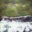
A large settlement mound on the coast edge, incorporating remains from the Iron Age to the medieval period.
A succession of structures, floors, hearths, midden deposits and long cists have been revealed, investigated and destroyed by coastal erosion. This multi-phase site has been used for settlement and burials with a succession of structures, deposits and inhumations from the Iron Age onwards. The coastal face of the mound contains a sequence of layers and stone structures visible in the eroding section.
A recent geophysical survey of the area behind the coast edge revealed features which are thought to be Iron Age and Norse/medieval buildings up to 30m back from the current coast edge.
Finds recovered include bone and antler tools, rotary and saddle quern stones, a steatite cup, iron knife, clay loom weights, a weaving comb, a bronze pin, a 10th century coin and pottery including Iron Age, Norse and medieval types.
Visited by Scotland's Coastal Heritage at Risk (SCHARP) 7 January 2015

