
Knockinhaglish


Cashel (Medieval)(Possible), Church (Medieval)(Possible), Fort (Prehistoric)
Site Name Knockinhaglish
Classification Cashel (Medieval)(Possible), Church (Medieval)(Possible), Fort (Prehistoric)
Canmore ID 43449
Site Number NS48SE 2
NGR NS 4875 8490
Datum OSGB36 - NGR
Permalink http://canmore.org.uk/site/43449


- Council Stirling
- Parish Drymen
- Former Region Central
- Former District Stirling
- Former County Stirlingshire
NS48SE 2 4875 8490.
(NS 4875 8490) Knockinhaglish (NAT) Site of Church (NR)
OS 6" map, (1959)
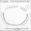
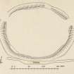
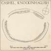
Cashel and Church site, Knockinhaglish: This oval enclosure measures 220' E-W by 175' N-S within an earthen bank with an external quarry-ditch. The bank is spread to a width of as much as 22', and in the ENE arc, where best preserved, it stands to a height of 9" above the level of the interior, and 6' above the bottom of the ditch. At this point the ditch is 1' in depth below the level of the surrounding ground. There are two entrances, both of which appear to be original; one, 18' in width, on the W, and the other, 24' in width, on the NE. A break through both bank and ditch on the N is modern. The interior is featureless and the whole structure lies within a wood. One of the channels draining the wood passes close to the S side of the enclosure and impinges upon the ditch for a length of 100'.
Smith (1896), considered that this was probably the site of a church of St Kessog, and recorded that "remains of buildings" could still be traced in his time. Nothing survives today, but the account of the site given in the Ordnance Survey Name Book (ONB 1860) says that the authorities consulted stated that "a number of years ago when it was trenched and planted, there were raised several human bones and the foundation of an old building."
RCAHMS 1963; visited 1952; J G Smith 1896; Name Book 1860.
The Knockinhaglish enclosure is as described above. The interior is tree and bracken covered but contains no trace of any building.
Surveyed at 1:2500.
Visited by OS (R D) 17 March 1965.
Field Visit (August 1978)
Knockinghaglish NS 487 849 NS48SE 2
What may be the remains of a fort measuring 67m by 53m within a spread earthen rampart and external ditch stand in a wood W of Finnich Toll. 'Remains of buildings' were noted in the interior in 1896 and 'several human bones and the remains of an old building' were discovered earlier in the 19th century when trees were being planted.
RCAHMS 1979, visited August 1978
(Name Book, Stirling, no. 9, p. 102; Smith 1896, 74; RCAHMS 1963, p. 164, no. 160)
Note (7 August 2014 - 16 November 2016)
The remains of what may be a fortified enclosure are situated on the E end of a spur of a low hill in Knockinhaglish Wood. Oval on plan, it measures 65m from ENE to WSW by 51m transversely (0.27ha) within a rampart spread about 6m in thickness but rising little more than 0.3m in height internally. Where best preserved on the NE, however it stands about 1.8m above the bottom of a shallow external ditch up to 4.5m in breadth. A gap in the rampart and ditch on the N is relatively recent, but there are original entrances on the NE and W. The interior is now featureless, but the OS Name Book (Stirlingshire, No.9, p 102), collated about 1860, notes that 'a number of years ago when it was trenched and planted, there were raised several human bones and the foundation of an old building', which probably accounts for its appearance on the 1st edition OS 25-inch map as 'Site of Church' (Stirlingshire 1865, sheet 20.11). This is almost underpins J Guthrie Smith's belief that this was probably the site of a church of St Kessog (Smith 1893, 74), in its turn leading to its inclusion in the County Inventory for Stirlingshire (RCAHMS 1963, 164, no. 160, fig 58) as a cashel or monastic enclosure.
Information from An Atlas of Hillforts of Great Britain and Ireland – 16 November 2016. Atlas of Hillforts SC1419

