
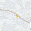
Clydebank, Duntocher


Fortlet (Roman), Roman Fort (Roman)
Site Name Clydebank, Duntocher
Classification Fortlet (Roman), Roman Fort (Roman)
Alternative Name(s) Golden Hill Park; Antonine Wall, Golden Hill Park Roman Fort, Annexe And Bathhouse
Canmore ID 43265
Site Number NS47SE 12
NGR NS 4953 7264
Datum OSGB36 - NGR
Permalink http://canmore.org.uk/site/43265


- Council West Dunbartonshire
- Parish Old Kilpatrick (Clydebank)
- Former Region Strathclyde
- Former District Clydebank
- Former County Dunbartonshire
NS47SE 12 4953 7264
See also NS47SE 83.00.
(NS 4953 7264) Roman Fort (site of)
OS 6" map (1957)
Roman fort - Golden Hill, Duntocher. Exploratory trenches cut in 1933 by Mr John Clarke revealed that the ramparts of the fort were probably of turf and not stone.
G Macdonald 1934
The fort was re-located by trenching in 1948 and further excavations between 1949-51 revealed its entire Antonine plan and the course of the Antonine Wall across Golden Hill Park.
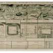
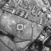
The earliest structure was a fortlet 60ft square internally defended by a turf rampart set on a 12ft wide stone foundation and a surrounding ditch. Later, an irregularly shaped fort of only circa 1/2 acre internal area was added to the east side, the fortlet then serving as a small military enclosure. The fort was also defended by turf rampart set on a stone foundation, and by 3 ditches on the east, and south sides. An annexe with an internal area of almost twice that of the fort, adjoined it on the west. A central stone building of more than one period and two sets of barrack block post holes were found within the fort and building post holes were found in the fortlet.
The finds, all 2nd century, are with the Hunterian Museum, Glasgow. A full excavation report and early biblographic history are given by Robertson.
A S Robertson 1957
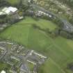
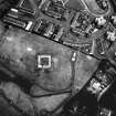
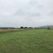
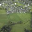
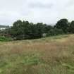
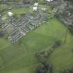
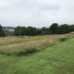
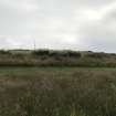
The site of the fort is now occupied by a park and football pitch and the surface has been so disturbed as to make it impossible to identify any features.
Visited by OS (DS) 17 January 1957
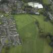
Air photographs show Golden Hill and vague vegetation mark detail of the fort and fortlet. In 1977-8 the stone base of the fortlet was exposed on behalf of Clydebank District Council, and in 1979 the Council created a "Roman Garden" north west of the fort.
A S Robertson 1979
No change to report of OS (DS). The recent exposures of the fortlet wall have been back filled, but a surrounding protection fence remains. There are no known plans for Clydebank District Council to permanently display or mark the site (information from D Breeze, Historic Scotland, December 1980).
The "Roman Garden" is an ornamental flower bed at NS 4958 7274. Sites of Fortlet and Fort re-surveyed at 1:1250.
Visited by OS (JRL) 19 December 1980
Possible pottery kiln.
D J Breeze 1987
A study of utilitarian pottery from the Antonine Wall has distinguished small numbers of locally made vessels with North African affinities at nine or 10 forts. Similar vessels at Chester and others made by Legio XX at the Holt works depot, one with a potter's graffito in neo-Punic, suggest the presence of North Africans. Detachments sent from Britain to Pius' Mauretanian war of AD 146-9 may have brought North Africans back with them to Britain (possibly including legionary recruits or transfers, and Moorish irregulars or levies). At the western sector of the Antonine Wall, changes in the legionary work-stints may be linked to troop reductions for the war, as the mural barrier and Bearsden and Duntocher fort interiors were still unfinished. After the conflict, Bearsden and Duntocher were each partitioned to make an annexe and their internal buildings re-planned and completed; a programme of annexe construction began at other forts, and secondary alterations were made to many existing fort interiors. All may be connected with changes in units or in the composition of the returning garrisons, now perhaps mixed and augmented with small numbers of North African troops. Possible epigraphic evidence is examined.
V Swan 1999.
Scheduled with length of Antoinine Wall [from NS 4940 7278 to NS 4960 7264] as Antonine Wall, Golden Hill Park Roman fort, annexe and bathhouse.
Information from Historic Scotland, scheduling document dated 2 February 1999.
NS 494 728 An archaeological evaluation was undertaken in November 2004 as the line of the Antonine Wall and its associated ditch might cross the SW edge of the site. The Roman fort of Golden Hill Park and its related bathhouse lie directly to the S. A total of 64m2 was investigated by means of evaluation trenches, though test pits were necessary in most areas to reach natural alluvial deposits. Modern made ground was identified to the S of the site, while made ground of 20th-century date and redeposited natural alluvial deposits associated with the burn were revealed in the N and E. No significant archaeological features or deposits were encountered.
Archive to be deposited in the NMRS.
Sponsor: Stuart McElney.
M Roy 2004
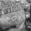
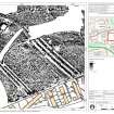
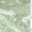
Features associated with the Antonine Wall (NS47SE 83) and the Antonine period fortlet, fort and annexe (NS47SE 12) have been identified in gradiometer data captured within Golden Hill Park.
The line of the Antonine Wall (NS47SE 83) follows that depicted on the 2022 edition of the digital OS MasterMap, running from NW to SE though Golden Hill Park. In the NW of the park the ditch has been recorded as a single linear negative anomaly 4.3m across. This splits into three ditches at the N corner of the annexe of Duntocher fort (NS47SE 12). This triple-ditch system extends for a distance of 139m to the S boundary of the park. The outer (NE) ditch measures 3m across, the central ditch 3m and the inner ditch 4.1m. The ditches are separated by berms 4.1m across. Causeways are visible across all three ditches.
Some 6.3m SW of the inner ditch a pair of narrow negative linear trends, set 5.5m apart, run parallel with the Antonine ditches. This conforms to the expected width of the Antonine Wall rampart base and so can be interpreted as surviving elements of the rampart. A series of discrete positive anomalies recorded on the berm between the inner ditch and the rampart may represent defensive pits called cippi.
The fortlet, fort and annexe (NS47SE 12) abut the Antonine Wall triple-ditch system (NS47SE 83). The fortlet (NS 49579 72684) is considered to pre-date the fort and annexe. It is visible as a square enclosure formed by a weak linear trend, representing the outer ditch of the fortlet, surrounding a 5.5m broad band of dipolar anomalies enclosing an area measuring 15.9m across. This response is caused by the buried rampart base. A series of positive linear anomalies within the fortlet appear to align with the ramparts and may relate to internal structures.
The NE defences of the fort and annexe are formed by the triple-ditch system of the Antonine Wall (NS27SE 83) described above, while the ditches of the SW defences have been recorded as three negative linear responses some 55m to the SW. The inner (NE) ditch of the SW defences measures 2.7m across, the central ditch 2.1m and the outer ditch 3m. No causeways across the ditches can be identified. The SE rampart has been partially detected at the S extent of the park as a negative linear anomaly 8.6m in length and extending from NE to SW from the NE rampart of the fort. The NW defences have not been detected.
The enclosed area is divided into fort and annexe by a rampart represented by a pair of weak negative linear trends. These trends extend from SW to NE from the S ditches of the fort towards the S corner of the fortlet. There are a small number of discrete positive anomalies visible between the linear trends, probably representing stones forming the base of the rampart.
What may be the remains of buildings have been recorded within both the fort and annexe. Within the SW section of the fort, negative and positive linear trends interspersed with discrete positive anomalies form a broadly rectangular pattern measuring 24m from NE to SW by 7m. These correspond with the location of a building identified during excavations in the 1950s (Robertson 1957: 14 & 15 figure 4) and may relate to the remains of this building, although they could also be an artefact of the excavation process. Similar negative and positive linear trends within the SW section of the annexe share a similar alignment and may also represent the remains of buildings.
Information from HES Archaeological Survey (N. Hannon), 22 June 2022.
Excavation (1933)
Roman fort - Golden Hill, Duntocher. Exploratory trenches cut in 1933 by Mr John Clarke revealed that the ramparts of the fort were probably of turf and not stone.
G Macdonald 1934
Excavation (1948 - 1951)
The fort was re-located by trenching in 1948 and further excavations between 1949-51 revealed its entire Antonine plan and the course of the Antonine Wall across Golden Hill Park.
The earliest structure was a fortlet 60ft square internally defended by a turf rampart set on a 12ft wide stone foundation and a surrounding ditch. Later, an irregularly shaped fort of only circa 1/2 acre internal area was added to the east side, the fortlet then serving as a small military enclosure. The fort was also defended by turf rampart set on a stone foundation, and by 3 ditches on the east, and south sides. An annexe with an internal area of almost twice that of the fort, adjoined it on the west. A central stone building of more than one period and two sets of barrack block post holes were found within the fort and building post holes were found in the fortlet.
The finds, all 2nd century, are with the Hunterian Museum, Glasgow. A full excavation report and early biblographic history are given by Robertson.
A S Robertson 1957
Field Visit (17 January 1957)
The site of the fort is now occupied by a park and football pitch and the surface has been so disturbed as to make it impossible to identify any features.
Visited by OS (DS) 17 January 1957
Excavation (1977 - 1978)
In 1977-8 the stone base of the fortlet was exposed on behalf of Clydebank District Council, and in 1979 the Council created a "Roman Garden" north west of the fort.
A S Robertson 1979
Field Visit (19 December 1980)
No change to report of OS (DS 1957). The recent exposures of the fortlet wall have been back filled, but a surrounding protection fence remains. There are no known plans for Clydebank District Council to permanently display or mark the site (information from D Breeze, Historic Scotland, December 1980).
The "Roman Garden" is an ornamental flower bed at NS 4958 7274. Sites of Fortlet and Fort re-surveyed at 1:1250.
Visited by OS (JRL) 19 December 1980
Reference (2 February 1999)
Scheduled with length of Antoinine Wall [from NS 4940 7278 to NS 4960 7264] as Antonine Wall, Golden Hill Park Roman fort, annexe and bathhouse.
Information from Historic Scotland, scheduling document dated 2 February 1999.
Reference (1999)
A study of utilitarian pottery from the Antonine Wall has distinguished small numbers of locally made vessels with North African affinities at nine or 10 forts. Similar vessels at Chester and others made by Legio XX at the Holt works depot, one with a potter's graffito in neo-Punic, suggest the presence of North Africans. Detachments sent from Britain to Pius' Mauretanian war of AD 146-9 may have brought North Africans back with them to Britain (possibly including legionary recruits or transfers, and Moorish irregulars or levies). At the western sector of the Antonine Wall, changes in the legionary work-stints may be linked to troop reductions for the war, as the mural barrier and Bearsden and Duntocher fort interiors were still unfinished. After the conflict, Bearsden and Duntocher were each partitioned to make an annexe and their internal buildings re-planned and completed; a programme of annexe construction began at other forts, and secondary alterations were made to many existing fort interiors. All may be connected with changes in units or in the composition of the returning garrisons, now perhaps mixed and augmented with small numbers of North African troops. Possible epigraphic evidence is examined.
V Swan 1999.
Aerial Photography (8 September 2006)
RCAHMS aerial survey of the site
Publication Account (2008)
A 1:25000 scale map of the Antonine Wall was published by RCAHMS in 2008. The map shows the course of the Antonine Wall on a modern map base, including areas where the Wall is in public ownership or care and can be visited. The data had been collated as part of the project to prepare maps for the World Heritage Site nomination bid.
Watching Brief (29 May 2012 - 10 August 2012)
Archaeological monitoring was required for Scottish Water Shared Services in support of the sewer repairs at Roman Road, Duntocher. The proposed study area at Duntocher, West Dunbartonshire currently exists as the grounds and car park for the Antonine Sports Centre. This area does not, according to the West of Scotland Archaeology Service and Royal Commission on the Ancient and Historical Monuments of Scotland, contain any known archaeological sites. However substantial Roman archaeological remains are present to the immediate East and North. The main monument is the remains of the Golden Hill section of the Antonine wall (Canmore ID 43265) and the Golden Hill Roman Fort, annexe and bathhouse (Canmore ID 43317). In the course of the works extensive areas of made ground and elements of 19th and 20th century structures were encountered to the south of the Duntocher Burn. To the north of the burn additional walls were located, while only short sections of these walls were exposed they may be of earlier origin than the 19th century. No significant archaeological finds were recovered during the course of these works.
Information from Oasis (rathmell1-120674) 26 March 2013
Geophysical Survey (August 2016)
NS 4953 7264 A magnetic and electrical resistance survey within and to the N of the fort was carried out in August 2016 to reconsider aspects of Anne Robertson’s interpretation of the layout of the fort based on her excavations in the 1950s. The results have highlighted several discrepancies, including
the presence of a triple ditch in front of the Antonine Wall, rather than the two proposed by Robertson, and a causeway across the triple ditch from the fortlet’s N gate rather than from Robertson’s N gate of the fort. The results also prompt a reconsideration of the spatial relationship of the fort with respect to the fortlet. Unexpected findings were a structure (c20 x 16m) S of the fortlet and more than two structures located in the supposed annexe area of the fort.
Report: WoSAS (intended)
Funder: Society of Antiquaries of Scotland
Richard Jones – University of Glasgow
(Source: DES, Volume 17)
Watching Brief (30 March 2016 - 23 September 2016)
These archaeological works were carried out as a requirement of (NS 49465Scheduled Monument Consent (Reference/Case ID 201507447) in support of the enhancement project within Goldenhill Park, Duntocher. They were designed to mitigate the impact on the archaeological remains from the renewal of the fence enclosure and works to improve the presentation of the wall base section within the enclosure.
The watching brief confirmed that the fence renewal was delivered in a manner that did not adversely affect the Scheduled Monument. Further, the insertion of gravel lined gullies to the front and rear of the wall did not disturb significant archaeological strata – though a sherd of samian ware was recovered. Community involvement through talks, guided tours and test pits (outwith the Scheduled Monument) sought to promote the works.
No other significant archaeological features or artefacts were disturbed by the works.
Information from OASIS ID: rathmell1-241870 (L McKinstry) 2016
Archaeological Evaluation (17 January 2017 - 26 January 2017)
Archaeological test pitting was carried out to inform the design of access improvement works at Goldenhill Park, Duntocher. Test pits predominantly exposed natural soil profiles or those altered in the 20th century. Potential ex situ wall base fabric was noted in one test pit to the W of the fort. Four sherds of pottery were recovered from a test pit within the fortlet, that also exposed the internal cobbled or metalled surface of the fortlet.
Information from Oasis (rathmell1-274826) 14 March 2018
Watching Brief (6 March 2017 - 2 June 2017)
Archaeological works comprising the monitoring of the implementation of access improvement works were carried out at Golden Hill Park Roman fort, annexe, and bathhouse in Duntocher, Clydebank. The access improvement works exposed natural soil profiles or those altered in the 20th century as part of park landscaping. No significant archaeology was discovered during the course of the works.
Information from OASIS ID: rathmell1-286568 (J Durnan) 2017
Geophysical Survey (12 July 2021 - 16 July 2021)
NS 49536 72680 The HES Archaeological Survey Team undertook geophysical (gradiometer and electro-magnetic) survey at Golden Hill Park (Duntocher). This forms part of a wider Antonine Wall Geophysical Survey project, which aims to address management and research questions relating to the Antonine Frontier by investigating the extent and significance of sub-surface archaeological remains at various locations within the World Heritage property.
The fieldwork was conducted between 12 July 2021 and 16 July 2021. In total 3.96ha were surveyed using a Sensys MXPDA gradiometer, with 0.21ha of that area also surveyed using a CMD Mini Explorer electro-magnetic device. The survey area contained the Duntocher Roman fort, fortlet, and bathhouse. The geophysical survey has produced good quality gradiometer results, which have successfully contributed to the aims of the survey. The electro-magnetic survey has provided moderate quality results, which have, in part, supported the gradiometer results and therefore provided a moderate contribution to the aims of the survey. There is a high level of confidence that the chosen mixed methodology and survey strategy was appropriate to assess the archaeological potential of the survey area.
The survey has successfully confirmed the course of the
Antonine Wall ditch through Golden Hill Park and the presence of a triple ditch system to the N of the wall which extends to the full width of the fort and incorporates a causeway that crosses all three ditches immediately N of the entrance to the fortlet. The survey also confirmed the location of the southern defensive ditches of the fort and identified traces of structures within both the fort and its annexe.
Archive: NRHE
Funder: Historic Scotland Foundation
Nick Hannon – Historic Environment Scotland (HES)
(Source: DES Vol 22)
Electromagnetic (12 July 2021 - 16 July 2021)
Historic Environment Scotland, Archaeological Survey Team, undertook electro-magnetic survey of 0.21ha at Golden Hill Park, West Dunbartonshire, between 12 July 2021 and 16 July 2021 using a hand-held GF Instruments CMD Mini Explorer. The survey, which forms part of a wider Antonine Wall Geophysical Survey project, covered the remains of Duntocher fortlet, fort and annexe and a stretch of the Antonine wall. It was undertaken to (a) better understand the relationship between the fortlet and fort, (b) investigate the internal layout of the fortlet and fort, (c) investigate the arrangement of ditches to the northeast of the fort, (d) identify any previously unidentified Roman features in the area and (e) to explore the area for other previously unrecorded archaeological features.
The survey results are summarised below, drawing out the main points from a comprehensive report outlining methodology and detailed results [1]. The archive also includes the unprocessed survey data, processed survey data [2], survey area extents which contain the survey metadata, and point, line, and polygon interpretations [3].
Survey within the fort and annexe has identified areas likely to contain internal structures, though the detail, layout and function of these structures is not clear. The survey has confirmed the presence of the triple-ditch system to the northeast of the fort and the causeways across the ditches at the northeastern gateway of the fortlet, supporting the findings of the gradiometer survey [1]
Visited by HES Archaeological Survey (N. Hannon, G. Geddes, L. Banaszek), 12 July to 16 July 2021.
[1] http://canmore.org.uk/collection/2239590
[2] http://canmore.org.uk/collection/2239594
[3] http://canmore.org.uk/collection/2239607
Magnetometry (12 July 2021 - 16 July 2021)
Historic Environment Scotland, Archaeological Survey Team, undertook gradiometer survey of 3.9ha at Golden Hill Park, West Dunbartonshire, between 12 July 2021 and 16 July 2021 using a hand-propelled Sensys MXPDA system mounted on a Sensys F-type non-magnetic cart. The survey, which forms part of a wider Antonine Wall Geophysical Survey project, covered the remains of Duntocher fortlet, fort and annexe, a bathhouse and a stretch of the Antonine wall. It was undertaken to (a) better understand the relationship between the fortlet and fort, (b) investigate the internal layout of the fortlet and fort, (c) investigate the possibility of a southern gateway to the fort, (d) investigate the arrangement of ditches to the northeast of the fort, (e) investigate any extra-mural settlement between the fort and the bathhouse, (f) identify any previously unidentified Roman features in the area and (g) explore the area for other previously unrecorded archaeological features.
The survey results are summarised below, drawing out the main points from a comprehensive report outlining methodology and detailed results [1]. The archive also includes the unprocessed survey data, processed survey data [2], survey area extents which contain the survey metadata, and point, line, and polygon interpretations [3].
Survey within the fortlet, fort and annexe has identified areas likely to contain internal structures. The detail, layout and function of these structures is not clear. The most significant outcome of the survey is to confirm the presence of a triple-ditch system to the northeast of the fort, which at present is a unique feature along the line of the Antonine Wall. The ditch system does not appear to extend beyond the extents of the fort and annexe, suggesting that the construction of the fort, the annexe, and the triple-ditch system were contemporary. If this is the case, this indicates that the fortlet was superseded by a fort built around its location and the triple-ditch system constructed at or around the same time, with the fort sub-divided into fort and annexe at a later date. This would support Swan’s (1999) interpretation of the sequence of this site.
The causeways across this ditch system relate to the northeastern gateway of the fortlet, indicating that the ditches were dug when the fortlet’s gateway was still in use. As no additional causeways have been identified crossing the triple-ditch system, the fort does not appear to have had further gateways along its northeast rampart. If the fortlet gate remained the northeastern gateway for the fort, direct access to the smaller fort envisaged in the sequence proposed by Robertson (1957) would not be possible, providing further support for the construction of a larger fort and sub-division to create the annexe at a later date.
No extra-mural activity of Roman date has been identified in the survey area, though this cannot be fully assessed as many of the areas likely to contain these features were not surveyable.
The survey has identified a possible enclosure which may pre-date the Roman occupation of the site, though the dating of this feature is not certain [4]. Traces of post-medieval rig and furrow cultivation and field boundaries have also been identified, with the location of a bandstand depicted on the revised edition of the Ordnance Survey 25-inch map (Dunbartonshire 1939, sheet nXXIII.6) also clearly visible [5].
Visited by HES Archaeological Survey (N. Hannon, A. McCaig, G. Geddes, L. Banaszek), 12 July to 16 July 2021.
[1] http://canmore.org.uk/collection/2239590
[2] http://canmore.org.uk/collection/2239594
[3] http://canmore.org.uk/collection/2239607
[4] http://canmore.org.uk/site/373299
[5] http://canmore.org.uk/site/373300

