
Lewis, Rudha Shilldinish


Promontory Fort (Prehistoric)(Possible), Settlement (Medieval)
Site Name Lewis, Rudha Shilldinish
Classification Promontory Fort (Prehistoric)(Possible), Settlement (Medieval)
Alternative Name(s) Rubha Shilldinish; Rubdha Shilldinish, Holm
Canmore ID 4304
Site Number NB43SE 1
NGR NB 4546 3063
Datum OSGB36 - NGR
Permalink http://canmore.org.uk/site/4304


- Council Western Isles
- Parish Stornoway
- Former Region Western Isles Islands Area
- Former District Western Isles
- Former County Ross And Cromarty
NB43SE 1 4546 3063
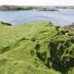
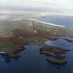
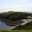
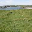
'On the summit of Rudha Shilldinish, a peninsula connected to the land to the NW by a very narrow neck of land and rising about 30ft above sea level, are the merest fragments of a dun. The site covers an area about 100 yards in length from E to W and 80 yards in breadth and is well adapted for defence, the sides being precipitous except towards the NW. For a short distance along the southern flank, on the edge of the cliff, a mound of stones about 8ft in width and rising one ft above the interior with a single course of the outer facing in position is all that remains of the defences. The interior of the dun has been under cultivation in late times and the foundations of a homestead are still in evidence.'
RCAHMS 1928, visited 13 June 1914.
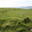
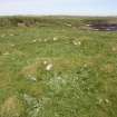
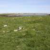
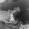
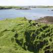
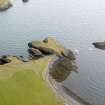
NB 454 306. This is a fort. The peninsula is still being eroded by the sea, but the remains of the enclosing rampart, as described by RCAHMS can be traced for 60m along the S side, for 68m along the N side and for 8m across the isthmus. There is a narrow gap in the middle of this last stretch, but it may well be modern and the original entrance probably lay to the N of it, where the defences were staggered. At least four houses and associated yards existed inside the fort, as well as lazy beds.
Visited by OS (ALFR) assistant archaeology officer, 22 April 1964.
Scheduled as Rubha Shilldinish, promontory fort and homestead.
Information from Historic Scotland, scheduling document datd 27 January 1992.
(Name cited as Rubdha Shilldinish, Holm). A survey of this site was undertaken by the Lewis and Harris Archaeology Group in June 1992. The enclosing rampart survives on the S side of the promontory as an earthen bank while on the northern edge it is of well constructed squared masonry. The entrance is of at least two phases. A number of apparently associated huts and enclosures lie in the southern part of the promontory. Later occupation of the site is focused on a substantial stone built rectilinear hall with an annexe to the SW and another to the N. To the W of this are a group of similar but slighter structures and enclosures. Almost all the remaining area is taken up with lazy beds. Amongst the lazy beds on the landward side of the approach causeway are traces of a further rampart.
Sponsor: Glasgow Archaeological Society.
C M Cunningham and S Hothersall 1992.
Field Visit (13 June 1914)
…on the summit of Rudha Shilldinish, a peninsula connected to the land to the NW by a very narrow neck of land and rising about 30ft above sea level, are the merest fragments of a dun. The site covers an area about 100 yards in length from E to W and 80 yards in breadth and is well adapted for defence, the sides being precipitous except towards the NW. For a short distance along the southern flank, on the edge of the cliff, a mound of stones about 8ft in width and rising 1ft above the interior with a single course of the outer facing in position is all that remains of the defences. The interior of the dun has been under cultivation in late times and the foundations of a homestead are still in evidence.'
RCAHMS 1928, visited 13 June 1914.
OS map: Lewis xxvii (unnoted)
Note (29 January 2015 - 13 December 2016)
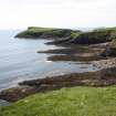
This fortification occupies a large heart-shaped promontory forming the E side of Holm Bay, and is connected on the NW to the shore by no more than a narrow ridge of eroded till rising above the beaches to either side. The promontory is girt with cliffs all along its N and E flanks, though on the S a grass-grown slope gives way to a broad expanse of eroded outcrops. The scale of the defences is unclear, for there is little sign of a stone wall where the ground rises up from the neck, though there is evidently a thick bank extending along the lip of the promontory on this flank and round onto the S; the slope below the bank along the S side is studded with stones, but exposures of the core of the bank at the W tip and on the NW indicate that it is largely earthen, and, unusually for a promontory fort, it can be traced around most of the margin. The area enclosed describes a V on plan, with its apex on the W, and measures 92m in length both from NE to SW along its northern arm, and from E to W along its southern arm (0.3ha). It is largely occupied however by the grass-grown footings of a series of rectangular buildings, at least one of which has been a very substantial structure, and also a series of associated enclosures. The impression is that perhaps this is in its present configuration not a prehistoric fort, but rather a medieval or post-medieval stronghold.
Information from An Atlas of Hillforts of Great Britain and Ireland – 13 December 2016. Atlas of Hillforts SC2765

