
Caldwell Tower, Old Barn


Tower House (Medieval)
Site Name Caldwell Tower, Old Barn
Classification Tower House (Medieval)
Alternative Name(s) Tower Of The Place Of Caldwell
Canmore ID 43014
Site Number NS45NW 4
NGR NS 42231 55130
Datum OSGB36 - NGR
Permalink http://canmore.org.uk/site/43014


- Council East Renfrewshire
- Parish Neilston (Renfrew)
- Former Region Strathclyde
- Former District Renfrew
- Former County Renfrewshire
NS45NW 4 4223 5512.
(NS 42231 55130) Tower (NAT)
OS 6" map (1969)
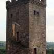
Caldwell Tower, standing on a mound, is a small, free-standing tower of probable 16th century origin. Square on plan, of good coursed rubble, it contains three storeys beneath the parapet. This is carried on two courses of individual corbels, set chequerwise. The crenellations seem to have been renewed and the roof is modern. The door at ground floor level is in the W wall and admits to the vaulted basement, which does not communicate with the upper storeys. The first floor, also vaulted, is reached via a modern forestair. The flooring above has been altered, presumably at the same time as the roof. The windows are small, and there are signs of built-up gun-loops in the walling. The fabric throughout is in fair condition. This tower is thought to have been part of a larger, courtyard-type castle.
N Tranter 1965; W Macfarlane 1907
NS 422 552 An archaeological watching brief was conducted during the excavation of a trench for a new electricity pole during the rebuild/refurbishment of the overhead line from Bowfield to Caldwell. This lay within an area of archaeological sensitivity surrounding the 16th-century Caldwell Tower and remains of Caldwell Castle. The excavation of a trench revealed a layer containing large sub-rounded stones, which may be rubble from the demolition of the castle in the late 17th century.
Full report lodged with the NMRS.
Sponsor: PLPC Ltd.
E Jones 2001.
There is no change to the existing record.
Visited by RCAHMS (AGCH) 4 June 2007.
Watching Brief (2001)
NS 422 552 An archaeological watching brief was conducted during the excavation of a trench for a new electricity pole during the rebuild/refurbishment of the overhead line from Bowfield to Caldwell. This lay within an area of archaeological sensitivity surrounding the 16th-century Caldwell Tower and remains of Caldwell Castle. The excavation of a trench revealed a layer containing large sub-rounded stones, which may be rubble from the demolition of the castle in the late 17th century.
Full report lodged with the NMRS.
Sponsor: PLPC Ltd.
E Jones 2001.

