
Barnweill


Moated Site (Medieval)
Site Name Barnweill
Classification Moated Site (Medieval)
Canmore ID 42873
Site Number NS43SW 8
NGR NS 40687 30118
Datum OSGB36 - NGR
Permalink http://canmore.org.uk/site/42873


- Council South Ayrshire
- Parish Craigie
- Former Region Strathclyde
- Former District Kyle And Carrick
- Former County Ayrshire
NS43SW 8 4068 3011.
(NS 4069 3011) Earthwork (NR)
OS 6" map (1969)
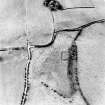
In 1857, this feature was described (Name Book 1857) as a square 'camp' (allegedly Roman). Three sides were defined by a ditch, 6ft deep, while the fourth merged with a steep natural slope. The internal area was level with the surrounding ground. A standing stone, about 3ft by 2ft and 4ft high, was also noted, a short distance SE.
Paterson, who gives a similar description, considers this to be a law or seat of justice associated with Barnweill Castle (see NS43SW 10: it is more probable that this was the castle site).
J Paterson 1863
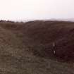
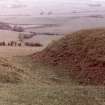
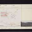
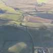
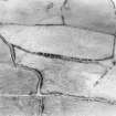
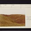
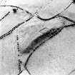
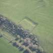
At this site is a rectangular mound, 25.2 by 11.6m, surrounded on three sides by a well-defined ditch. Its surface in now broken but has been quite level formerly. Its appearance tends to support the idea of a castle site. It is not unlike a motte in view of its commanding situation on the edge of an escarpment. No traces of building foundations were found, nor was there a causeway across the ditch.
Visited by OS (JD) 15 May 1954
Homestead moat.
SDD 1979
This is doubtless the rectangular motte near Craigie Castle noted by Talbot.
E R Talbot 1975
As described, and well preserved. Talbot is probably correct in describing this as a rectangular motte as opposed to it being a homestead moat or castle earthwork. Broad rig and furrow terminates well short of the ditch on the SW.
Resurveyed at 1:2500.
Visited by OS (JRL) 22 June 1982
Field Visit (27 May 1952)
This site was included within the RCAHMS Marginal Land Survey (1950-1962), an unpublished rescue project. Site descriptions, organised by county, are available to view online - see the searchable PDF in 'Digital Items'. These vary from short notes, to lengthy and full descriptions. Contemporary plane-table surveys and inked drawings, where available, can be viewed online in most cases - see 'Digital Images'. The original typecripts, notebooks and drawings can also be viewed in the RCAHMS search room.
Information from RCAHMS (GFG) 19 July 2013.
Field Visit (April 1985)
Barnweill NS 4068 3011 NS43SW 8
This earthwork is situated on the edge of an escarpment 300m WSW of Barnweill farmsteading. It is sub-rectangular on plan (24.2m by 12m) and is enclosed on the WSW, SSE and ENE by a substantial rock-cut ditch up to 7m broad and 2m deep; the upcast has probably been used to raise the level of the interior, which bears some signs of disturbance. These remains are probably to be identified with the 'Old Castle of Barnwyil depicted by Pont. About 40m to the SE, and occupying the summit of the hill, there are the remains of banks and other earthwork features, probably no more than the result of quarrying.
RCAHMS 1985, visited April 1985.
(Pont 1654; Name Book, Ayrshire, No. 18, p. 41; Paterson 1863-6, i, 265; Smith 1895, 128-9; Stell 1985a, 15).

