
Craigie Hill


Fort (Prehistoric)(Possible)
Site Name Craigie Hill
Classification Fort (Prehistoric)(Possible)
Canmore ID 42869
Site Number NS43SW 4
NGR NS 4224 3276
Datum OSGB36 - NGR
Permalink http://canmore.org.uk/site/42869


- Council South Ayrshire
- Parish Craigie
- Former Region Strathclyde
- Former District Kyle And Carrick
- Former County Ayrshire
NS43SW 4 4224 3276.
(NS 4224 3276) Fort (NR)
OS 6" map (1969)
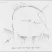
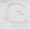
The fort on the summit of Craigie Hill, 500ft OD, is not easy to locate as its single rampart is heavily denuded.
Information from K A Steer (RCAHMS) letter and plan, 1954.
Only the slight suggestion of the course of a wall was found, on the SW perimeter, at NS 4221 3273.
Visited by OS (JLD) 3 June 1954
A large southerly extension of Craigiehill stone quarry has destroyed all trace of this fort.
Visited by OS (JRL) 21 June 1982
Field Visit (17 March 1953)
This site was included within the RCAHMS Marginal Land Survey (1950-1962), an unpublished rescue project. Site descriptions, organised by county, are available to view online - see the searchable PDF in 'Digital Items'. These vary from short notes, to lengthy and full descriptions. Contemporary plane-table surveys and inked drawings, where available, can be viewed online in most cases - see 'Digital Images'. The original typecripts, notebooks and drawings can also be viewed in the RCAHMS search room.
Information from RCAHMS (GFG) 19 July 2013.
Reference (1957)
This site is noted in the ‘List of monuments discovered during the survey of marginal land (1951-5)’ (RCAHMS 1957, xiv-xviii).
Information from RCAHMS (GFG), 24 October 2012.
Field Visit (March 1985)
Craigie Hill NS 4224 3276 NS43SW 4
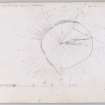
The fort that was situated on Craigie Hill has been destroyed by quarrying; it measured about 84m by 71m within a single rampart.
RCAHMS 1985, visited (SH) March 1985.
(RCAHMS Survey of Marginal Lands).
Note (5 August 2014 - 16 November 2016)
The remains of this fort have been destroyed by stone quarrying. It was already heavily degraded by the time of its discovery in 1953 on the rounded summit of Craigie Hill. Slightly oval on plan, it measured about 80m from NE to SW by 70m transversely (0.44ha) within a single rampart which where best preserved around the western half of the circuit formed a stony scarp some 1.8m in height; no trace of the rampart survived on the SE, nor upon the NE, which was already being quarried. The rocky interior was featureless.
Information from An Atlas of Hillforts of Great Britain and Ireland – 16 November 2016. Atlas of Hillforts SC1362

