
Sundrum


Motte (Medieval)(Possible)
Site Name Sundrum
Classification Motte (Medieval)(Possible)
Canmore ID 42758
Site Number NS42SW 13
NGR NS 4152 2144
Datum OSGB36 - NGR
Permalink http://canmore.org.uk/site/42758


- Council South Ayrshire
- Parish Coylton (South Ayrshire)
- Former Region Strathclyde
- Former District Kyle And Carrick
- Former County Ayrshire
Field Visit (October 1995)
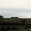
Sundrum NS 4152 2144 NS42SW 13
What may be a motte fashioned from a natural mound is situated on the edge of a steep river escarpment 470m' ENE of Sundrum Castle The mound stands to a height of 4m and its roughly circular level summit is 19m in diameter; there are traces of possible ditches at the base of the mound on the NW and SE.
RCAHMS 1985, visited (IMS) October 1985.

