|
Photographs and Off-line Digital Images |
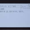
AYD 17/1 P |
Records of the Royal Commission on the Ancient and Historical Monuments of Scotland (RCAHMS), Edinbu |
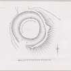
Ink plan; Laighpark earthwork.
Photographic copy |
c. 1953 |
Item Level |
|
|
Prints and Drawings |
AYD 17/2 |
Records of the Royal Commission on the Ancient and Historical Monuments of Scotland (RCAHMS), Edinbu |
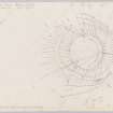
Plane-table survey; Laighpark, enclosure. |
28/5/1953 |
Item Level |
|
|
Manuscripts |
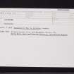
MS 36/174 |
Records of the Royal Commission on the Ancient and Historical Monuments of Scotland (RCAHMS), Edinbu |
Field notebook of K A Steer (RCAHMS). 'S7 - Ayr, Wigtown'. |
24/5/1952 |
Item Level |
|
|
Prints and Drawings |
AYD 17/1 |
Records of the Royal Commission on the Ancient and Historical Monuments of Scotland (RCAHMS), Edinbu |
Inked plan; Laighpark, enclosure. |
c. 1953 |
Item Level |
|
 |
On-line Digital Images |
DP 147619 |
Records of the Royal Commission on the Ancient and Historical Monuments of Scotland (RCAHMS), Edinbu |
Inked plan; Laighpark, enclosure. |
c. 1953 |
Item Level |
|
 |
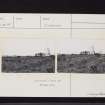
On-line Digital Images |
DP 147620 |
Records of the Royal Commission on the Ancient and Historical Monuments of Scotland (RCAHMS), Edinbu |
Plane-table survey; Laighpark, earthwork. |
28/5/1953 |
Item Level |
|
 |
Digital Files (Non-image) |
WP 000760 |
Records of the Royal Commission on the Ancient and Historical Monuments of Scotland (RCAHMS), Edinbu |
Scanned copy of RCAHMS Marginal Land Survey unpublished typescripts (Ayrshire), with index. |
1952 |
Item Level |
|
|
Digital Files (Non-image) |
WP 006384 |
Records of CFA Archaeology Ltd, archaeologists, Musselburgh, East Lothian, Scotland |
Environmental Statement: 'Appendix 14.2: Characterisation of the Settings of Cultural Heritage Features within the ZTV Study Areas from where one more or more Parts of the SWS Project are Predicted to be Visually Perceptible', South West Scotland Project |
12/2008 |
Item Level |
|
 |
On-line Digital Images |
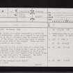
SC 2424889 |
Records of the Ordnance Survey, Southampton, Hampshire, England |
Laighpark, NS41NW 15, Ordnance Survey index card, Recto |
1958 |
Item Level |
|
 |
On-line Digital Images |
SC 2424890 |
Records of the Ordnance Survey, Southampton, Hampshire, England |
Laighpark, NS41NW 15, Ordnance Survey index card, Recto |
1958 |
Item Level |
|
 |
On-line Digital Images |
SC 2424891 |
Records of the Ordnance Survey, Southampton, Hampshire, England |
Laighpark, NS41NW 15, Ordnance Survey index card, Recto |
1958 |
Item Level |
|
 |
On-line Digital Images |
SC 2424892 |
Records of the Ordnance Survey, Southampton, Hampshire, England |
Laighpark, NS41NW 15, Ordnance Survey index card, Recto |
1958 |
Item Level |
|
 |
On-line Digital Images |
SC 2424893 |
Records of the Ordnance Survey, Southampton, Hampshire, England |
Laighpark, NS41NW 15, Ordnance Survey index card, Recto |
1958 |
Item Level |
|
 |
On-line Digital Images |
SC 2424894 |
Records of the Ordnance Survey, Southampton, Hampshire, England |
Laighpark, NS41NW 15, Ordnance Survey index card, page number 1, Recto |
1958 |
Item Level |
|
|
All Other |
551 166/1/1 |
Records of the Ordnance Survey, Southampton, Hampshire, England |
Archaeological site card index ('495' cards) |
1947 |
Sub-Group Level |
|


