
Laighpark


Enclosed Settlement (Iron Age)
Site Name Laighpark
Classification Enclosed Settlement (Iron Age)
Alternative Name(s) Highpark
Canmore ID 42658
Site Number NS41NW 15
NGR NS 4004 1926
Datum OSGB36 - NGR
Permalink http://canmore.org.uk/site/42658


- Council South Ayrshire
- Parish Coylton (South Ayrshire)
- Former Region Strathclyde
- Former District Kyle And Carrick
- Former County Ayrshire
NS41NW 15 4004 1926.
(NS 4004 1926) Earthwork (NR)
OS 1:10000 map (1981)
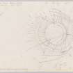
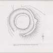
A ring camp, placed on a slope, enclosed by a ditch 204 paces in circumference. There is a rampart on the outside of the ditch on the N. On the S side the rampart is on the inside of the ditch. On the W side there is another ditch on the outer side of the rampart. There are only traces of a ditch on the E side.
J Smith 1895; Name Book 1856
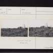
Situated about 290ft OD, on the crest of a slope with the ground falling away sharply to the N and E, this near-circular earthwork, where best preserved on the W side, consists of an inner and outer rampart with a medial ditch, enclosing an area some 40.0m in diameter. The outer 'ditch' on the NW and SE is a modern drain.
Visited by OS (JLD) 12 May 1954
No change to the previous field report.
Surveyed at 1:2500.
Visited by OS (EGC) 16 September 1968
This earthwork, which is almost certainly a settlement, lies in dense undergrowth on a fairly steep slope. It has a level interior with the remains of a rampart on the uphill side; the ditch was substantial although it is now heavily silted. There is no trace of a causeway and the position of the entrance is not evident but it was probably on the SE side.
Visited by OS (MJF) 25 September 1980
Field Visit (28 May 1953)
This site was included within the RCAHMS Marginal Land Survey (1950-1962), an unpublished rescue project. Site descriptions, organised by county, are available to view online - see the searchable PDF in 'Digital Items'. These vary from short notes, to lengthy and full descriptions. Contemporary plane-table surveys and inked drawings, where available, can be viewed online in most cases - see 'Digital Images'. The original typecripts, notebooks and drawings can also be viewed in the RCAHMS search room.
Information from RCAHMS (GFG) 19 July 2013.
Field Visit (October 1985)
Laighpark NS 4004 1926 NS41NW 15
A roughly circular earthwork is situated 200m SSW of Laighpark. It measures 45m in diameter within a ditch up to 11m broad and 1.5m deep; a break in the ditch on the E probably marks the position of the original entrance. The date and purpose of the earthwork are unknown.
RCAHMS 1985, visited (PC) October 1985.
(Smith 1895, 163-4; RCAHMS Survey of Marginal Lands; NMRS, AYD/17/1).

