|
Manuscripts |
MS 993/5 |
Records of FIRAT Archaeological Services, archaeologists, Helensburgh, West Dunbartonshire, Scotland |
Loch Lomond Islands Survey. An archaeological assessment commissioned by Friends of Loch Lomond.
Report on phase 3 the crannog survey |
2/1998 |
Item Level |
|
|
Manuscripts |
MS 977/2 |
|
Cashel Farm. The forest for a thousand years: environmental Statement (extracts)
including appendix VI: An archaeological Strategy
RESTRICTED: NOT FOR PUBLIC ACCESS |
1/1996 |
Item Level |
|
|
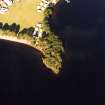
Photographs and Off-line Digital Images |
D 56942 CN |
RCAHMS Aerial Photography |
Oblique aerial view centred on the remains of the castle with the faint outline of the remains of the crannog adjacent, taken from the W. |
26/7/1999 |
Item Level |
|
|
Manuscripts |
MS 36/180 |
Records of the Royal Commission on the Ancient and Historical Monuments of Scotland (RCAHMS), Edinbu |
Field notebook of R W Feachem (RCAHMS). Stirlingshire, Perthshire, Peebles-shire, and Lanarkshire. |
1955 |
Item Level |
|
 |
On-line Digital Images |
SC 1724413 |
RCAHMS Aerial Photography |
Oblique aerial view centred on the remains of the castle with the faint outline of the remains of the crannog adjacent, taken from the W. |
26/7/1999 |
Item Level |
|
 |
On-line Digital Images |
SC 2424690 |
Records of the Ordnance Survey, Southampton, Hampshire, England |
Strathcashell Point, Loch Lomond, NS39SE 11, Ordnance Survey index card, Recto |
1958 |
Item Level |
|
 |
On-line Digital Images |
SC 2424691 |
Records of the Ordnance Survey, Southampton, Hampshire, England |
Strathcashell Point, Loch Lomond, NS39SE 11, Ordnance Survey index card, page number 1, Recto |
1958 |
Item Level |
|
|
All Other |
551 359/462/6 |
General Collection |
Stirlingshire File |
|
Sub-Group Level |
|
|
All Other |
551 166/1/1 |
Records of the Ordnance Survey, Southampton, Hampshire, England |
Archaeological site card index ('495' cards) |
1947 |
Sub-Group Level |
|


