|
Photographs and Off-line Digital Images |
H 88662 CS |
W Black |
Oblique aerial view of Langbank, taken from the N |
10/1974 |
Item Level |
|
|
Photographs and Off-line Digital Images |
E 72949 S |
General Collection. Glass Lantern Slides |
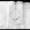
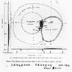
Photographic copy of plan drawing. |
|
Item Level |
|
 |
On-line Digital Images |
SC 1330906 |
General Collection. Glass Lantern Slides |
Photographic copy of plan drawing. |
|
Item Level |
|
|
Photographs and Off-line Digital Images |
E 67602 S |
Papers of Joseph Harrison Maxwell, archaeologist, Glasgow, Scotland |
Photographic copy of drawing showing plan of Langbank crannog, River Clyde.
|
1901 |
Item Level |
|
 |
On-line Digital Images |
SC 1330908 |
Papers of Joseph Harrison Maxwell, archaeologist, Glasgow, Scotland |
Photographic copy of drawing showing plan of Langbank crannog, River Clyde. |
c. 1901 |
Item Level |
|
|
Digital Files (Non-image) |
GV 006450 |
Historic Environment Scotland |
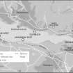
Map of Clyde Crannogs; Dumbuck, Langbank East, Langbank West, Erskine |
12/2015 |
Item Level |
|
 |
On-line Digital Images |
SC 2077108 |
Historic Environment Scotland |
Map of Clyde Crannogs; Dumbuck, Langbank East, Langbank West, Erskine |
12/2015 |
Item Level |
|
 |
On-line Digital Images |
SC 2424440 |
Records of the Ordnance Survey, Southampton, Hampshire, England |
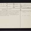
Langbank West, River Clyde, NS37SE 9, Ordnance Survey index card, page number 1, Recto |
1958 |
Item Level |
|
|
All Other |
551 443/2 |
Dr Alex G C Hale |
Archive material relating to research into crannogs for PhD thesis and later work |
1968 |
Group Level |
|


