
Langbank West, River Clyde


Crannog (Prehistoric)
Site Name Langbank West, River Clyde
Classification Crannog (Prehistoric)
Alternative Name(s) Langbank West Crannog; Clydeview
Canmore ID 42420
Site Number NS37SE 9
NGR NS 38130 73550
Datum OSGB36 - NGR
Permalink http://canmore.org.uk/site/42420


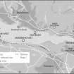
- Council Renfrewshire
- Parish Erskine
- Former Region Strathclyde
- Former District Renfrew
- Former County Renfrewshire
NS37SE 9 38130 73550
Not to be confused with:
NS47SW 22 NS 4355 7283 Langbank Crannog ('Baby Island'), or
NS47SW 29 NS 4050 7328 Langbank East Crannog
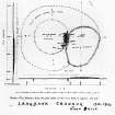
(NS 3812 7355) Langbank West Crannog: Due to a threat by the construction of the new M8 motorway, preliminary investigations by the Renfrew Archaeological Society confirmed that this structure is roughly circular, about 100ft across, and is marked by a well-defined ring of piles, especially on the W side.
Information from Mr J Hunter (Paisley Museum), 3 November 1972.
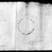
NS 3813 7355. A low mound of consolidated stones was fieldwalked and surveyed during the summer of 1997. Along the western margin of the site three small piles were found and further investigation revealed them to have square sections. Contour survey of the site and the surrounding sandbanks showed a raised linear feature, and indicated that the whole site is situated on a raised mound. Visual survey found a small amount of animal bones of the surface.
Sponsors: Society of Antiquaries of Scotland, Wingate Foundation.
A G C Hale 1997.
Scheduled as 'Langbank, crannog 180m ENE of Clydeview... the remains of a marine crannog.'
(Basic description added).
Information from Historic Scotland, scheduling document dated 24 February 2011.
Reference (7 November 1972)
(NS 3812 7355) Langbank West Crannog: Due to a threat by the construction of the new M8 motorway, preliminary investigations by the Renfrew Archaeological Society confirmed that this structure is roughly circular, about 100ft across, and is marked by a well-defined ring of piles, especially on the W side.
Information from OS (JLD) 7 November 1972
(Information from Mr J Hunter (Paisley Museum), 3 November 1972).

