 |
On-line Digital Images |
SC 1007538 |
RCAHMS Aerial Photography |
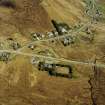
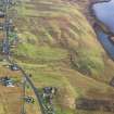
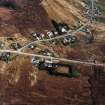
Oblique aerial view centred on part of Leurbost crofting township, Lewis, taken from the WNW. |
23/4/2005 |
Item Level |
|
 |
On-line Digital Images |
SC 1007572 |
RCAHMS Aerial Photography |
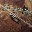
Oblique aerial view centred on part of the crofting township, taken from the SE. |
23/4/2005 |
Item Level |
|
 |
On-line Digital Images |
SC 1009290 |
RCAHMS Aerial Photography |
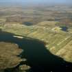
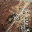
General oblique aerial view centred on the township, taken from the S. |
23/4/2005 |
Item Level |
|
 |
On-line Digital Images |
SC 1009291 |
RCAHMS Aerial Photography |
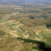
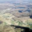
General oblique aerial view centred on the township, taken from the SSW. |
23/4/2005 |
Item Level |
|
 |
On-line Digital Images |
DP 110489 |
RCAHMS Aerial Photography Digital |
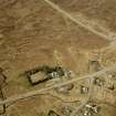
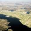
Oblique aerial view of the remains of Leurbost township, with associated head dyke, field system and lazy beds, Isle of Lewis, taken from the WNW. |
14/11/2011 |
Item Level |
|
 |
On-line Digital Images |
SC 1690935 |
RCAHMS Aerial Photography |
Oblique aerial view centred on part of the crofting township, taken from the W. |
23/4/2005 |
Item Level |
|
 |
On-line Digital Images |
SC 1690936 |
RCAHMS Aerial Photography |
Oblique aerial view centred on part of the crofting township, taken from the SE. |
23/4/2005 |
Item Level |
|
 |
On-line Digital Images |
SC 1692281 |
RCAHMS Aerial Photography |
General oblique aerial view centred on the township, taken from the SSW. |
23/4/2005 |
Item Level |
|
 |
On-line Digital Images |
SC 1692282 |
RCAHMS Aerial Photography |
General oblique aerial view centred on the township, taken from the S. |
23/4/2005 |
Item Level |
|
 |
On-line Digital Images |
SC 1692301 |
RCAHMS Aerial Photography |
Oblique aerial view centred on part of the crofting township, taken from the WNW. |
23/4/2005 |
Item Level |
|
 |
On-line Digital Images |
SC 2345434 |
Records of the Ordnance Survey, Southampton, Hampshire, England |
Lewis, Leurbost, NB32NE 3, Ordnance Survey index card, Recto |
1958 |
Item Level |
|


