
Lewis, Bragar, General


Head Dyke(S) (Post Medieval), Lazy Beds (Post Medieval), Township(S) (Period Unassigned), Township(S) (Period Unassigned), Village (Period Unassigned)
Site Name Lewis, Bragar, General
Classification Head Dyke(S) (Post Medieval), Lazy Beds (Post Medieval), Township(S) (Period Unassigned), Township(S) (Period Unassigned), Village (Period Unassigned)
Canmore ID 4196
Site Number NB24NE 8
NGR NB 2850 4790
NGR Description Centred on NB 2850 4790
Datum OSGB36 - NGR
Permalink http://canmore.org.uk/site/4196


- Council Western Isles
- Parish Barvas
- Former Region Western Isles Islands Area
- Former District Western Isles
- Former County Ross And Cromarty
NB24NE 8.00 centred on 2950 4790
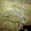
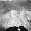
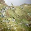
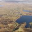
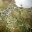
North and South Bragar are shown on Gibbs map of 1817 (surveyed by G Chapman 1807-9) as a series of small scattered settlements within the township boundaries. By the 1st edition of the OS 6-inch map (Island of Lewis Ross-shire 1853, sheet 8) a more complex plan is shown. Dodgshon (1994) interprets this complex plan into three phases.
The first phase comprising the small scattered settlement shown on Gibbs map and also shown on the OS 1st edition 6-inch map.
The second phase is an early but unsuccessful attempt at a crofting system laid around two N/S roads with some attempt to lay out a field-system.
The third phase was the establishment of a further crofting township, laid out in a linear fashion near or at the edge of the arable area.
R A Dodgshon 1994.
Re-examination of the 1st edition of the OS 6-inch map (Island of Lewis, Ross-shire 1853, sheet 8) broadly confirms Dodgshon (1994) interpretation.
The 1st phase is a number of scattered settlements within the present arable land some of which are shown on Gibbs map (1817). Each of these settlements or townships have been abandoned, probably when the first crofting system was introduced (NB24NE 8.01, NB24NE 8.02, NB24NE 8.03, NB24NE 8.04 )
The first crofting phase comprises two groups, laid out along two N-S roads with the croft boundaries running E-W.
In addition an extensive system of head-dykes (NB24NE 52), which may be partly associated with these townships, lies to the S.
This pattern starting with scattered settlement, followed by a failed crofting system and then a linear crofting township is not restricted to North and South Bragar and may be seen in a number of nearby townships eg. Arnol, South Shawbost and Barvas.
8.01 2805 4860 Township
8.02 2955 4876 Township
8.03 2920 4890 Township
8.04 2833 4835 Township
8.05 2965 4848 Township
8.06 2805 4915 Township
8.07 2870 4855 Crofting Township
8.08 2925 4860 Crofting Township
8.09 2992 4800 Township
8.10 281 481 Crofting Township
8.11 295 479 Crofting Township
8.12 2960 4770 Township
8.13 2920 4760 Farmstead; Building; Enclosures; Walls
8.14 2780 4925 Township
8.15 2931 4917 Farmstead
8.16 2932 4822 Farmstead
8.17 2827 4899 Enclosure
8.18 2915 4823 Enclosure
8.19 2977 4827 Building (Possible)
8.20 2882 4736 Enclosure
8.21 2934 4811 Enclosures
8.22 2890 4890 Enclosures; Walls
8.23 2917 4739 Head-dykes
Information from RCAHMS (AKK) 18 February 1996.
NB 2850 4790 Site identified as part of a desk-based assessment and walk-over survey.
Jacobs, 2007.

