
Lurg Moor


Hut Circle (Prehistoric)
Site Name Lurg Moor
Classification Hut Circle (Prehistoric)
Canmore ID 41376
Site Number NS27SE 7
NGR NS 2978 7376
Datum OSGB36 - NGR
Permalink http://canmore.org.uk/site/41376


- Council Inverclyde
- Parish Greenock
- Former Region Strathclyde
- Former District Inverclyde
- Former County Renfrewshire
Field Visit (4 November 1964)
The remains of a much mutilated hut circle 10.2m in diameter are as described by Newall. From the S side of the entrance the wall extends outwards towards the NE for a distance of some 6.0m to flank the entrance. The turf dyke enclosure W of the hut appears to be modern.
Surveyed at 1:2500.
Visited by OS (WDJ), 4 November 1964.
Desk Based Assessment (17 October 1979)
NS27SE 7 2978 7376
(NS 2978 7376) Hut Circle (NR)
OS 25" map (1967)
This hut circle measures 27ft to 30ft in diameter within a heavily-built wall 5ft to 6ft thick, with a 6 ft wide entrance in the E. It is buttress-built on the W. A wall runs diagonally across the entrance for 18ft to the NE. To the W, a turf dyke partly encloses about 1 acre.
By analogy with sites at Martin Glen (NS26NW 9) and Rottenburn (NS26NE 14), this hut circle is probably of Late Bronze Age - Early Iron Age date (Newall 1976).
Information from OS (IF) 17 Oct 1979
Sources: F Newall 1964; F Newall 1959; F Newall 1976.
Field Visit (8 April 2015)
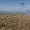
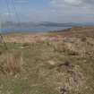
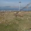
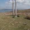
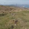
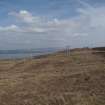
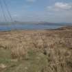
This hut circle sits on a knoll at the northern edge of Lurg Moor overlooking lower ground. It measures about 12.5m in diameter over a wall that has been reduced to a grass-grown spread of stones up to 2m in thickness and 0.2m in height. Both the entrance and part of the wall have been damaged by the erection of electricity poles and associated stanchions. A short section of turf bank which runs NE from the entrance may relate to others in the vicinity to the W and N.
Visited by RCAHMS (GFG) 8 April 2015.

